Hochstadt am Main
| coat of arms | Germany map | |
|---|---|---|

|
Coordinates: 50 ° 9 ′ N , 11 ° 10 ′ E |
|
| Basic data | ||
| State : | Bavaria | |
| Administrative region : | Upper Franconia | |
| County : | Lichtenfels | |
| Management Community : | Hochstadt-Marktzeuln | |
| Height : | 280 m above sea level NHN | |
| Area : | 13.78 km 2 | |
| Residents: | 1622 (Dec. 31, 2019) | |
| Population density : | 118 inhabitants per km 2 | |
| Postal code : | 96272 | |
| Area code : | 09574 | |
| License plate : | LIF, STE | |
| Community key : | 09 4 78 127 | |
| LOCODE : | DE YHB | |
| Community structure: | 7 districts | |
| Address of the municipal administration: |
Wolfslocher Strasse 4 96272 Hochstadt a. Main |
|
| Website : | ||
| Mayor : | Max Zeulner ( CSU ) | |
| Location of the municipality of Hochstadt a.Main in the Lichtenfels district | ||
Hochstadt am Main (officially Hochstadt a.Main ) is a municipality in the Upper Franconian district of Lichtenfels . The place of the same name is both the capital and the seat of the municipal administration.
geography
Geographical location
The place Hochstadt is about 7.5 km east of Lichtenfels. The highest point in the community is the Eulenberg at 457 m.
Community structure
|
history
The place was first mentioned in 1182.
Incorporations
On May 1, 1978, the previously independent municipalities of Obersdorf with the municipal parts of Anger, Reuth and Thelitz and Wolfsloch with Burgstall were incorporated.
Population development
In the period from 1988 to 2018, the population fell from 1,693 to 1,650 by 43 people or 2.5%. On December 31, 1998, Hochstadt am Main had 1,755 inhabitants.
politics
The community is a member of the Hochstadt-Marktzeuln administrative community based in Marktzeuln . A branch of the administrative association is located in Hochstadt.
mayor
The first mayor is Max Zeulner (CSU).
Municipal council
The municipal council has 13 members including the first mayor.
- CSU : 7 seats
- Free voters : 3 seats
- SPD : 2 seats
(Status: local election on March 15, 2020)
coat of arms
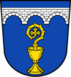
| Blazon : “In blue a golden chalice from which a golden abbot's staff grows; above it a continuous, three-arched, bricked silver bridge. " | |
Architectural monuments
traffic
The station Hochstadt-Marktzeuln lies on the Bamberg-Hof railway and is the starting point of the Franconian Forest Railway . Hochstadt is located directly on federal highway 173 . The Franconian Marienweg runs through the village .
literature
- Hans Russnak: Hochstadt am Main . Lichtenfels: Obermain-Tagblatt, 1982. A short chronicle for the 800th anniversary of the first documentary mention
Web links
- Local government
- Hochstadt am Main: Official statistics of the LfStat (PDF; 1.04 MB)
Individual evidence
- ↑ "Data 2" sheet, Statistical Report A1200C 202041 Population of the municipalities, districts and administrative districts 1st quarter 2020 (population based on the 2011 census) ( help ).
- ^ Federal Statistical Office (ed.): Historical municipality directory for the Federal Republic of Germany. Name, border and key number changes in municipalities, counties and administrative districts from May 27, 1970 to December 31, 1982 . W. Kohlhammer GmbH, Stuttgart / Mainz 1983, ISBN 3-17-003263-1 , p. 696 .
- ↑ Mayor. Hochstadt am Main community, accessed on August 18, 2020 .
- ^ Entry on the coat of arms of Hochstadt am Main in the database of the House of Bavarian History


