
Administrative community Hochstadt-Marktzeuln
| coat of arms | Germany map | |
|---|---|---|
 Help on coat of arms |
Coordinates: 50 ° 10 ′ N , 11 ° 10 ′ E |
|
| Basic data | ||
| Existing period: | 1980– | |
| State : | Bavaria | |
| Administrative region : | Upper Franconia | |
| County : | Lichtenfels | |
| Area : | 20.64 km 2 | |
| Residents: | 3166 (Dec. 31, 2019) | |
| Population density : | 153 inhabitants per km 2 | |
| License plate : | LIF, STE | |
| Association key : | 09 4 78 5446 | |
| Association structure: | 2 municipalities | |
| Association administration address : |
Am Flecken 29 96275 Marktzeuln |
|
| Website : | ||
| Chairman : | Josef Stark | |
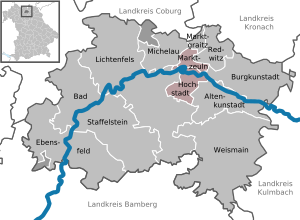
| Location of the Hochstadt-Marktzeuln administrative community in the Lichtenfels district | ||
  |
||

The Hochstadt-Marktzeuln administrative community is an amalgamation of Hochstadt a. Main and Marktzeuln .
geography
The administrative community is located in the Upper Franconian district of Lichtenfels . Hochstadt a. Main has 1622 inhabitants on an area of 13.78 km², Marktzeuln 1544 inhabitants on an area of 6.86 km². The seat of the administrative association is Marktzeuln.
history
Until December 31, 1979, both communities belonged to the administrative community Redwitz an der Rodach . On January 1, 1980, they left there and have since formed their own community to deal with the administrative business.
Individual evidence
- ↑ "Data 2" sheet, Statistical Report A1200C 202041 Population of the municipalities, districts and administrative districts 1st quarter 2020 (population based on the 2011 census) ( help ).
- ↑ Law on the change in the membership of municipalities in administrative communities of 10 August 1979 ( GVBl p. 223)