
Bayreuth – Hollfeld railway line
| Kreuzstein – Hollfeld junction | |||||||||||||||||||||||||||||||||||||||||||||||||||||||||||||||||||||||||||||||||||||||||||||||||||||||||||||||||||||||||||||||||||||||||||||||||||||
|---|---|---|---|---|---|---|---|---|---|---|---|---|---|---|---|---|---|---|---|---|---|---|---|---|---|---|---|---|---|---|---|---|---|---|---|---|---|---|---|---|---|---|---|---|---|---|---|---|---|---|---|---|---|---|---|---|---|---|---|---|---|---|---|---|---|---|---|---|---|---|---|---|---|---|---|---|---|---|---|---|---|---|---|---|---|---|---|---|---|---|---|---|---|---|---|---|---|---|---|---|---|---|---|---|---|---|---|---|---|---|---|---|---|---|---|---|---|---|---|---|---|---|---|---|---|---|---|---|---|---|---|---|---|---|---|---|---|---|---|---|---|---|---|---|---|---|---|---|---|
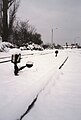
 Remaining track on Jakobstrasse in Bayreuth
| |||||||||||||||||||||||||||||||||||||||||||||||||||||||||||||||||||||||||||||||||||||||||||||||||||||||||||||||||||||||||||||||||||||||||||||||||||||
 | |||||||||||||||||||||||||||||||||||||||||||||||||||||||||||||||||||||||||||||||||||||||||||||||||||||||||||||||||||||||||||||||||||||||||||||||||||||
| Route number : | 5002 | ||||||||||||||||||||||||||||||||||||||||||||||||||||||||||||||||||||||||||||||||||||||||||||||||||||||||||||||||||||||||||||||||||||||||||||||||||||
| Course book section (DB) : | formerly 842 | ||||||||||||||||||||||||||||||||||||||||||||||||||||||||||||||||||||||||||||||||||||||||||||||||||||||||||||||||||||||||||||||||||||||||||||||||||||
| Route length: | 31.1 km | ||||||||||||||||||||||||||||||||||||||||||||||||||||||||||||||||||||||||||||||||||||||||||||||||||||||||||||||||||||||||||||||||||||||||||||||||||||
| Gauge : | 1435 mm ( standard gauge ) | ||||||||||||||||||||||||||||||||||||||||||||||||||||||||||||||||||||||||||||||||||||||||||||||||||||||||||||||||||||||||||||||||||||||||||||||||||||
| Maximum slope : | 19.2 ‰ | ||||||||||||||||||||||||||||||||||||||||||||||||||||||||||||||||||||||||||||||||||||||||||||||||||||||||||||||||||||||||||||||||||||||||||||||||||||
| Minimum radius : | 250 m | ||||||||||||||||||||||||||||||||||||||||||||||||||||||||||||||||||||||||||||||||||||||||||||||||||||||||||||||||||||||||||||||||||||||||||||||||||||
|
|||||||||||||||||||||||||||||||||||||||||||||||||||||||||||||||||||||||||||||||||||||||||||||||||||||||||||||||||||||||||||||||||||||||||||||||||||||
The Bayreuth – Hollfeld line was a branch line in Bavaria . It branched off in Bayreuth at the Kreuzstein junction from the Schnabelwaid – Bayreuth railway line and led to Hollfeld in northern Franconian Switzerland .
history
Building history
The plans for the construction of this line go back to the 1860s. Originally a longer route was planned, in the west via Forchheim - Höchstadt to Rothenburg ob der Tauber , in the east to the Fichtelgebirge . A connection to Bamberg via Scheßlitz was also considered. For cost reasons (difficult topographical conditions), only the route mentioned above was realized. It was built from 1902 to 1904 and opened on March 12, 1904. The driving time for the almost 33-kilometer route was two hours back then. In the beginning there were only three pairs of trains traveling a day.
vehicles

During the Länderbahn era (until 1920) and the DRG era, Bavarian local railway locomotives of the D VII , D VIII and D XI series were stationed in Bayreuth . The D II series also came onto the line in handover traffic. Steam-powered motor locomotives of the ML 2/2 series were stationed in Thurnau until the 1920s and thus ran at least for the first few kilometers of the route from the main train station to Bayreuth Altstadt. From around 1929, the 98.10 class was at home in Bayreuth and used on all three branch lines. In 1949 it was replaced by the 98.11 series , which ran the route with the 64 series until the end of steam operation.
With the railcars VT 95 that began in the 1950s "Verdieselung" one, later the series sparked V 100 , the steam locomotives from. Shunting locomotives of the types Köf II , Köf III and V 60 also came onto the line in transfer traffic. Towards the end of operations, multiple units of the series VT 24 and 614 ran as scheduled , and a double multiple unit built for a Danish private railway ( DUEWAG type Ym multiple unit) was put into service in 1968/69 for testing in regular traffic.
Route description


The exact length of the route (in the middle of the operating buildings of the terminal stations) was 32.73 km (straight line 20.5 km). Bayreuth Central Station is 343.72 m above sea level, the Hollfeld terminus was 41.58 m higher. The highest point of the route was between Pittersdorf and Mistelgau (439.82 m), the lowest after the Kreuzstein junction at the bridge over the Sendelbach (346.90 m). The smallest arc radius was 250 m, the largest gradient was 19.2 ‰ (between Plankenfels and Wadendorf ).
From Bayreuth Hbf to the Kreuzstein junction, the trains used the Schnabelwaid – Bayreuth railway in both directions. The main line to Kirchenlaibach, which is also single-track, runs parallel to this point, so that in this section the impression of a double-track railway line can be created.
The Kreuzstein station, which was put into operation as a stop , was later upgraded to a train station by expanding the track system , but remained unoccupied. There was a siding to a tank farm, a junkyard and other companies. The Gasworks the Bayreuth Stadtwerke south of the courtyard garden also had its own railway siding. This siding branched off in the area of today's university , west of Universitätsstraße, in a narrow curved track to the right of the main line. It then ran initially in a northerly direction, turned west in the area of the bridge over the Sendelbach and reached the company premises after about 800 meters after crossing Birkenstrasse . In the first few years, the locomotives pushed the wagons along the entire route and through a gate into the gas works building. Around 1960, a track system was set up east of Birkenstrasse to park and bypass trains. From there, the wagons could be pulled into the gas works by means of a winch , crossing the street. A siding of the gasworks had been planned since 1918 and was only built in 1949. The dismantling probably took place after the coal gasification plant was shut down at the end of the 1960s before the extension of Sendelbachstrasse (today's Universitätsstrasse).
The BayWa , a coal merchant and sawmill on Justus-Liebig-Straße and the warehouses in the industrial area on Otto-Hahn-Straße were served via siding that branched off between the Röhrensee stop and the Bayreuth Altstadt train station . Some were still used sporadically in the early 1990s.
On June 26, 1909, after almost 1½ years of construction, the branch line to Thurnau was put into operation. From the main train station to the Altstadt district, it used the existing infrastructure of the Hollfelder Bahn. Immediately at the north-western end of the appropriately rebuilt Bayreuth Altstadt station, it branched off to the north to Herzoghöhe station .
Shortly after the train station in the district of Old Town, the two had Meyernberg nearby brickyards a shared siding. The subsequent stop at Fantaisie-Eckersdorf, which was subsequently set up in 1907, was also located in Bayreuth's urban area.
Mistelgau, Plankenfels and Hollfeld owned larger, brick-built service buildings from the following train stations. In the Mistelbach and Obernsees train stations there were only small wooden agency buildings . Pittersdorf , Frankenhaag and Stechendorf - Welkendorf had loading tracks and were thus stops, the first two unoccupied, the latter was a rail agent. The other stations were simple stops. The Hollfeld terminus had three continuous tracks, plus several butt tracks . The train crew could spend the night in the engine house, a two-tier locomotive shed with a residential building. Like the train station and another outbuilding, it was preserved.

Kreuzstein junction (view towards the main train station, far right the line to Weiden ), 1986
Kreuzstein station, 1986
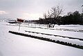
Kreuzstein train station in front of the Glasenweiher , 1986

Old town station with goods shed, 1987

Junction at the old town station: Hollfeld to the left, Thurnau to the right


Shutdown


The last trip, a special trip with a steam locomotive of the class 64 , which was once used , took place on September 28, 1974, with great approval from the population. The originally planned continuation of the operation in pure freight traffic was not considered, only as far as the Bayreuth Altstadt station it remained for 20 years. The tracks between Bayreuth old town and Hollfeld were dismantled very quickly, until Obernsees the route was converted into a cycle path and paved asphalt in the early 2000s.
The railway line between Obernsees and Plankenfels was used to expand and straighten the state road St 2186. The same happened with the district road BT 1 between Mistelgau and the confluence of the district road BT 2 southeast of Hardt (1 km southeast of Frankenhaag). Above the Plankenfels, the newly built state road St 2191 crosses the former route several times, some of which is still used as a dirt road. There is again a paved bike path between Stechendorf and Hollfeld.
At the end of the 1980s, when the University of Bayreuth was extensively expanded, the city administration was considering the establishment of a “University” stop. It was planned to be located directly east of the bridge over Emil-Warburg-Weg, would have been easily connected to local public transport and would at least have ensured that the first 0.7 km of the route (from the Kreuzstein junction) would have been preserved. In 1995 the city of Bayreuth signed the contract with DB to purchase the line from the Kreuzstein junction to Bayreuth Altstadt station. At the end of 1996, however, an expert opinion commissioned by her came to the conclusion that reactivating rail passenger transport was uneconomical. The planned passenger train operation therefore no longer took place, instead it was converted into a cycle path.
Until 1994, occasional special trips took place, usually with a train set of the series 614 , at least once with the class VT 11.5 . On May 31, 1992 the multiple unit 614 023 ran the route. On 30 September 1994, sparked German track the goods tariff point Bayreuth Old Town. The last DB freight train left the station on October 14, 1994. The last official passenger train ran between Röhrensee and Bayreuth Hauptbahnhof on June 4, 1995 , after a class 628 multiple unit commuting between Weidenberg and the Röhrensee stop every two hours on that day . The last car from one of the terminals was established in 1998 by two diesel locomotives of DFS picked up.
Only about 50 meters of track have been preserved as a monument in the old town. With a new building that has now been built on the site between the former Kreuzstein junction and Nürnberger Straße , every chance of restarting has been blocked.

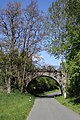
Railway bridge in Plankenfels

Former route near Wadendorf
Railway bridge near Moggendorf (city of Hollfeld)

Preserved station building in Hollfeld

Former machine house in Hollfeld, used for commercial purposes


Others
The writer Hans Max von Aufseß relates: “On the local railway line Bayreuth-Hollfeld there was an inclined plane near Mistelgau, on which we students alighted and walked comfortably next to the panting and crawling train. When the overexerted locomotive ran into Obernsees to get water on the same route, the passengers were thirsty too. However, after an agreement with the train driver, you could register your beer wishes. A waitress rushed up from the inn about 200 meters from the train station with as much silk as had been signaled and pre-ordered by the whistle of the locomotive. "
literature
- Robert Zintl: Bayreuth and the railroad . Gondrom, Bindlach 1992, ISBN 3-8112-0780-6 .
- Bernd Schmitt, Gerald Hoch: Branch lines in Upper Franconia . Michael Resch, Coburg 1999, ISBN 3-9805967-4-5 .
- Kerstin Schäfer: The high-rise buildings of the Upper Franconian branch lines. History, inventory and conversion . Michael Resch, Coburg 2013, ISBN 978-3-944237-05-3 .
Web links
- Excerpt from the course book from 1944
- Page for the 100th anniversary of the local railway line. Archived from the original on March 7, 2012 ; accessed on May 27, 2018 .
- www.achim-bartoschek.de - Description of the cycle path on the railway line
Individual evidence
- ^ Robert Zintl: Bayreuth and the Railway, p. 128 ff.
- ^ Siegfried Bufe: Railway in Upper Franconia , p. 228.
- ↑ Rail bus from Denmark on the route ( Memento from January 12, 2010 in the Internet Archive )
- ↑ Kurt Herterich: Im southeastern Bayreuth, p. 127.
- ↑ Kurt Herterich: Im southeastern Bayreuth, p. 55.
- ↑ a b Bernd Schmitt / Gerald Hoch: Branch lines in Upper Franconia, p. 106.
- ↑ Bernd Mayer: Bayreuth à la Carte, p. 91.