
Sendelbach (mistletoe)
| Sendelbach | ||
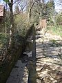
 Sendelbach at the Moritzhöfen bridge |
||
| Data | ||
| Water code | DE : 241262 | |
| location |
Germany
|
|
| River system | Rhine | |
| Drain over | Mistletoe → Red Main → Main → Rhine → North Sea | |
| Headwaters | Swamp runoff at the hollow mill in Bayreuth 49 ° 55 ′ 21 ″ N , 11 ° 35 ′ 37 ″ E |
|
| muzzle | in Bayreuth from the right and southeast into the mistletoe coordinates: 49 ° 56 '44.4 " N , 11 ° 34' 5.2" E 49 ° 56 '44.4 " N , 11 ° 34' 5.2" E
|
|
| length | 9.8 km (total length with Tappert ) | |
| Catchment area | 19.83 km² | |
| Left tributaries | Outflow of the Hohlmühlweiher , Aubach | |
| Right tributaries | Tappert | |
The Sendelbach (formerly: Sindel Bach) is the last natural tributary of the mistletoe before it flows into the Red Main . In Bayreuth it flows from the right and southeast into the water called Mistelbach there .
The Sendelbach is fed by a branch of the Tappert on the lower reaches of Bayreuth-Hohlmühle , which carries more water there than the Sendelbach itself. Downstream there are at least two more inflows from the Tappert before it finally flows into the Sendelbach at the level of the Dammallee .
geography
course


The Sendelbach rises a little below the fork of a branch canal that feeds the Hohlmühlweiher from the Tappert without an identifiable individual source in a swamp area. The local landscape as well as the beginning of the canalization of the Tappert at the junction suggest that the Sendelbach flows on the original route of the Tappert. The pond outlet flows into the Sendelbach and gives it more water than its headwaters.
Tappert and Sendelbach initially flow parallel to the north as far as the eastern edge of Bayreuth center. A flood retention basin was built in 2017 on the edge of the Oberkonnersreuth district south of Dr.-Konrad-Pöhner-Straße . Since the Sendelbach, the Tappert and the Aubach run underground in sections in the direction of the city, the dry storage tank should prevent the system from overflowing in the event of a flood of the century . Such events were most recently in January 1995 and in February 1909. The water of the three rivers - the Aubach between Thiergarten and Fürsetz by a Überleiter towards integrated to Tappert - can be dammed up to a height of 6.60 meters.
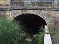
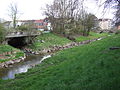
At the Kreuzsteinbad , the Sendelbach turns to the northwest and touches the city center in the south. In the urban area, it is largely channeled under streets and parking spaces, only in a few places, such as the bridge on Moritzhöfen Street, which was built in 1753, is it still visible in public space, but also on some private properties. Its most important tributary after the Tappert is the Aubach , which flows from the left and south in the inner city area and flows through the Röhrensee a little before in the urban zoo . The Sendelbach finally flows west of the core town of Bayreuth on the street Am Sendelbach from the right and south-east into the mistletoe , only about 0.3 km above its confluence with the Red Main .
In the middle of the 19th century the Sendelbach flowed directly into the Red Main. A north-facing map from around 1860 shows the dam pond with the Sendelbach tributaries from below and Tappert from the right. Further north you can see its confluence with the then course of the Red Main, into which the mistletoe flows a little further downstream on this map.
Lakes and streams, then and now


The Sendelbach used to feed the Long Pond, from which the former swimming school (today Kreuzsteinbad ) emerged. Down the stream, east of Birkenstrasse, was the Plassenburger Weiher, also known as the “Plassenweiher”.
Several arms of the Tappert drained into the naturally wet zone in the Sendelbachtal on the southwestern edge of the city wall. Especially since the establishment of a wood gas factory in 1852, this has carried abundant wastewater. The hospital pond can be found there as early as the first half of the 15th century. Later Margrave Friedrich III. at this point build the dam pond that once surrounded the city park. Between 1857 and 1860 it was drained and heaped up. There the brook now flows under the street Dammallee.
Tributaries from the source to the mouth
- Side arms of the Tappert at the upper reaches: from the left the outflow from the Hohlmühlweiher, shortly thereafter from the right a second arm and then from the right the outflow from the Glasenweiher fed by the Tappert.
- Aubach , from the left near the fork in the street Wittelsbacher Ring and Friedrichstrasse at 340 m above sea level. NN . Then the Sendelbach flows openly to the northwest in sections.
- Main channel of the Tappert from the right on the street Dammallee .
Ambiguities
Ph. Hirschmann wrote in 1928: “In an essay Die Weiher in und um Bayreuth , published in No. I of“ Bayreuther Land ”in 1927, I have already pointed out that the assumption that the Röhrensee is fed by the Sendelbach is based on a Error is based; ... For the local history lessons in the local schools, this correction should be given special attention in order to finally eliminate the naturalized wrong view of the Sendelbachlauf. "
The Röhrensee outflow (today's Aubach ) is also shown on old maps as the more important of the two watercourses. The course and name were not always clearly defined, which, by the way, also applies to other bodies of water such as the Tappert , the Aubach and the Glasenweiher.
gallery

Exit of the Sendelbach at the Moritzhöfen bridge
Sendelbach in Moritzhöfen

Stream bed behind the district court
Wilhelminenstrasse bridge

Stream bed north of Wilhelminenstrasse
Mouth of the Sendelbachs in the Mistelbach or mistletoe


Individual evidence
- ↑ a b Directory of stream and river areas in Bavaria - Main river area, page 9 of the Bavarian State Office for the Environment, as of 2016 (PDF; 3.3 MB)
- ↑ Total length of the main hydrological line Schelmgraben → Tappert → Sendelbach
- ^ Riediger plan from 1745 in Herbert Popp: Bayreuth - newly discovered, p. 341
- ^ Silent reserve for still waters in: Nordbayerischer Kurier of April 5, 2017, p. 10
- ↑ Kurt Herterich: Südliches Bayreuth, p. 17
- ↑ Gr. St. K. Reprinted by the Bavarian Land Survey Office 1981
- ↑ Kurt Herterich: Südliches Bayreuth, p. 72
- ↑ Kurt Herterich: In the southeast of Bayreuth, p. 41
literature
- Herbert Popp: Bayreuth - rediscovered . Ellwanger, Bayreuth 2007, ISBN 978-3-925361-60-9 .
Web links
- Catchment area of the Sendelbach on the UmweltAtlas (Bavarian State Office for the Environment)