Tappert (Sendelbach)
| Tappert | ||
|
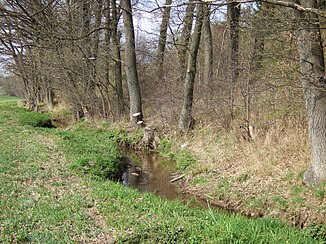
Tappert north of the hollow mill |
||
| Data | ||
| location | Bavaria | |
| River system | Rhine | |
| Drain over | Sendelbach → Mistel → Roter Main → Main → Rhine → North Sea | |
| source | at Unterschreez 49 ° 53 ′ 19 ″ N , 11 ° 34 ′ 31 ″ E |
|
| Source height | approx. 470 m above sea level NN | |
| muzzle | after crossing the Hofgarten underground in the Sendelbach coordinates: 49 ° 56 '25 " N , 11 ° 34' 26" E 49 ° 56 '25 " N , 11 ° 34' 26" E
|
|
| Right tributaries | Wolfsgraben (at Sorgeflieh ) | |
| Medium-sized cities | Bayreuth | |
The Tappert (originally Taphart) is a tributary of the Sendelbach . It runs mainly in the urban area of Bayreuth . Its lower course was channeled and diverted as early as the 12th century. The first map on which this is recorded dates from 1745.
geography
Upper course
The headwaters of the Tappert are located near the village of Unternschreez in the municipality of Haag in the Bayreuth district . There is no defined source, the young stream is fed from the meadows on the eastern slope of the Sophienberg. At least two watercourses are considered to be the origin. The source of the upper reaches furthest from the mouth (Schelmgraben) is on the southern edge of the village at about 470 m above sea level. NN. It dried up in the summer months, and the Teufelsgraben then hardly had any water either.
The stream initially flows roughly in a northerly direction, initially deepening quickly in a wooded area, soon changing over to the Bayreuth urban area and from the Thiergarten district onwards flows in a shallower hollow through the corridor. Until then, the inhabitants of the neighboring villages and hamlets call it Aubach, not to be confused with the nearby watercourse of the same name .
On the northern edge of Thiergarten, it fed the former Bayreuth extinguishing water ponds until the 1970s . In the event of a fire, the weirs were opened and the extinguishing water flowed into the city via the artificial canal system (described below). The ponds were largely filled with rubble from the Prinz-Leopold-Kaserne on Rathenaustraße, which was demolished in 1972. Remains of a dam and a weir as well as the remains of a pond are still preserved in the swampy area south of the district of Fürsetz.
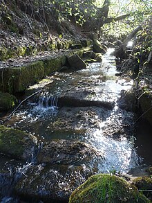
To the south of Karolinenhöhe, the Tappert, which flows from west to east, has an artificially created bed of sandstone blocks . At the height of Karolinenreuth, it reaches more densely populated areas, where it feeds the Kollerweiher pond created in the late 1960s and then two unnamed fish ponds. Shortly before the former Tapperts or Hollmühle (built in the 12th century, bought by the Hold brothers in 1482, destroyed in the Thirty Years' War) it was channeled and diverted towards the city center. Hollmüller's job was to keep the level of this sewer system constant. The area through which the water flows today belongs to Gut Hohlmühle.
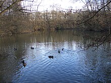
At the weir south of the Hohlmühle, the pond tributary branches off to the Hohlmühlweiher. The Sendelbach begins as an outflow from the marshland between the two canals . Its topography suggests that it follows the original course of the Tappert before the canalization. Shortly after its origin, more water flows to it from the pond than it leads there itself. There are two other outflows from the Tappert to the Sendelbach north of the Hohlmühle and at the Glasenweiher - also known as the Kreuzsteinweiher. The latter lay dry for years; around 1990 it was reactivated and developed into a natural body of water. Greylag geese breed on a small island , kingfishers have also been sighted and beavers have settled. There, the Tappert is forwarded via a complicated transfer system in the direction of Dürschnitz and the city center .
South of Dr.-Konrad-Pöhner-Strasse, a 60,000 m², 125 million liter flood retention basin was built in 2017 on the edge of the Oberkonnersreuth district . Since the Tappert, the Sendelbach, which runs parallel there, and the Aubach are channeled underground in sections in the direction of the city, the dry storage tank should prevent the system from overflowing in the event of a flood of the century . Such events were most recently in February 1909 and in January 1995. The water of the three rivers - the Aubach between Thiergarten and Fürsetz by a Überleiter to Tappert back involved - can be dammed up to a height of 6.60 meters. The control technology of the intake structure , which functions fully automatically via level measuring devices, can also be operated from the sewage treatment plant .
Sewer system
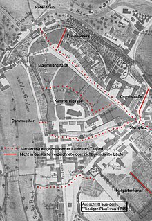
The Tappert in the city center is already shown in detail in the Riediger plan from 1745. His first run had a branch that turned northwards down today's Opernstrasse at the height of today's Sternplatz. It still exists under the property at Opernstrasse 7, but cannot be found in the Riediger plan. It is also not apparent from this map that there were two parallel branches in the course of today's Richard-Wagner-Strasse , one in the street and another behind the southern house front. J. S. König describes around 1800: "On the left side of the 1741 paved Rennweg, (today's Richard-Wagner-Straße), but away from the houses, the Tappert flows in from the gate (= Upper Gate)".
The Tappert has several functions. It still feeds the Glasenweiher fish pond, and in the past it also fed the larger Eimersweiher in the area of today's Neue Heimat housing estate. The ornamental canal in Bayreuth's Hofgarten palace park also receives its water from the Tappert. Mainly, however, it was created and used as an inner-city sewer. For this purpose it had been built open across the market square, an elongated street market , up to the mill door in the western city wall, after which it flowed into the Red Main , which then flowed there. The geographer and city historian Herbert Popp notes that it can be assumed that the Tappert “at times smelled more like a sewer and was probably less of a lively babbling brook”. It fulfilled another important function as an extinguishing water reservoir in the event of a fire. Bayreuth was ravaged by two devastating fires in 1605 and 1621.
A side canal branches off to the west at Sternplatz. It crosses under the buildings between Ludwigstrasse and Kanzleistrasse and flows back into Sendelbach at Dammallee. A second branch in a south-westerly direction leads through Kanzleistraße and then follows the course of today's Kämmereigasse. The last-mentioned street did not arise from a traffic necessity, but was only created during the construction of the Tappert. Apparently there was also a branch in the direction of Frauengasse.
The naturally wet zone in the Sendelbachtal southwest of the city wall was receiving waters for the drainage of several Tappertarms. Especially after the establishment of a wood gas factory in 1852, he carried abundant sewage with him. At this point there was initially the hospital pond, later that under the margrave Friedrich III. created dam pond. This was abandoned at the end of the 1850s, today the street Dammallee runs there.
The Tappert is now largely underground. The branch canals under the market and the Opera Street have no function and have been drained. The course that is traceable today leads from the Glasenweiher, after a bend in the Dürschnitz, under the Schützenplatz park to the Hofgarten. Here it forms the open decorative channel and feeds its side arm. To the east of the New Palace, it disappears underground again since the 1950s and has merged into the combined sewer system. The old underground canal from the time of the Margrave, which until then led it to the Sendelbach from Wilhelminenstrasse, is largely still there. In order to reduce the amount of water arriving in the sewage treatment plant, the 60 cm wide and 90 cm high sandstone vault is to be used again in the future. Here, however, plastic pipes are passed through the old tunnel. In November 2012, work was still in progress.
During the renovation of the market square in 2010, remnants of the former canal bed were found, but reactivation as a “town stream” was not possible due to the low location. Instead, a new water-bearing decorative channel was created in front of the northern house front.
Name of the upper course
While the naming is clear to the north of the hollow mill, the naming is not clear on the upper reaches. On most maps, the stream is called Tappert, but the residents of the neighboring towns from Unternschreez to Thiergarten call it Aubach. In some maps and publications, the upper course is also referred to as the Sendelbach.
Others
In August 2018, the Tappert above the Kollerweiher had dried up, and at the beginning of August 2019, some sections were already out of water.
gallery
literature
- Herbert Popp: Bayreuth - rediscovered . Ellwanger, Bayreuth 2007, ISBN 978-3-925361-60-9 .
Individual evidence
- ↑ Bavaria Atlas of the Bavarian State Government ( notes )
- ↑ a b c Archives of Gut Hohlmühle, Bayreuth
- ↑ a b Herbert Popp: Bayreuth - newly discovered, p. 65
- ↑ Kurt Herterich: Südliches Bayreuth, pp. 104/105
- ↑ a b Herbert Popp: Bayreuth - newly discovered, p. 340
- ↑ Rosa and Volker carbon home: Bayreuth from AZ, p.63
- ^ Nenninger: City map of Bayreuth (as of May 1, 1947), Ellwanger
- ↑ Where the beaver is allowed to gnaw in: Nordbayerischer Kurier of April 30, 2020, p. 13.
- ^ Silent reserve for still waters in: Nordbayerischer Kurier of April 5, 2017, p. 10
- ↑ Canals, alleys and a cooling pit in: Nordbayerischer Kurier of October 12, 2015, p. 7
- ↑ Nordbayerischer Kurier of November 13, 2013, p. 11: World Heritage Neighbor will grow
- ^ Rosa and Volker Kohlenheim: Bayreuth von AZ, p. 97
- ↑ a b bayreuth1320: CITY ARCHAEOLOGY
- ↑ Nordbayerischer Kurier of November 28, 2012, p. 13
- ↑ Creeks partially dried up in: Nordbayerischer Kurier from 18./19. August 2018, p. 17.
- ↑ Extreme drought causes brooks to dry up in: Nordbayerischer Kurier, September 3, 2019, p. 17.


