
Mistletoe (red main)
| mistletoe | ||
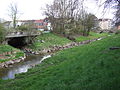
 Mistelbach in Bayreuth with the Carl-Burger-Strasse bridge |
||
| Data | ||
| Water code | DE : 24126 | |
| location |
Franconian Switzerland
|
|
| River system | Rhine | |
| Drain over | Red Main → Main → Rhine → North Sea | |
| source | from two source streams south of Hummeltal -Bärnreuth 49 ° 51 '50 " N , 11 ° 29' 37" O |
|
| Source height | approx. 505 m above sea level NN | |
| muzzle | in Bayreuth in the Red Main Coordinates: 49 ° 56 '53 " N , 11 ° 34' 6" E 49 ° 56 '53 " N , 11 ° 34' 6" E |
|
| Mouth height | approx. 335 m above sea level NN | |
| Height difference | approx. 170 m | |
| Bottom slope | approx. 12 ‰ | |
| length | 13.8 km | |
| Catchment area | 65.77 km² | |
The mistletoe is an almost 14 km long, left and western tributary of the Red Main in Upper Franconia . It is called Mistelbach in Bayreuth .
geography
course

_-_Mistelbach_(Wasserfall).JPG)

The mistletoe has two source streams that unite on the southern outskirts of Hummeltal -Bärnreuth. It flows into the Red Main in Bayreuth . In the city of Bayreuth, mistletoe had two artificial side channels. In the Geigenreuth district, a mill canal branched off to the Rückleinsmühle to the right of the stream and reached it again shortly before the Thurnau railway bridge . At the Hetzennest , to the left, was the branch to the Mühlgraben (also called Rießenbach ), which the street Am Mühlgraben reminds of. Shortly before the inflow of the Sendelbach, it came back to the main course.
In the Bayreuth urban area, the Mistelbach, which had been forced into a concrete channel for a long time, was renatured . The corresponding construction work began in 1987, initially the section between the confluence with the Red Main and Carl-Burger-Strasse was dismantled at a cost of 400,000 DM . The completion from there to the Y-house was completed in November 1994, it cost 450,000 DM. Base ramps were built for flood protection , which also serve the fish as a climbing aid.
Tributaries
- Näßgraben ( left )
- Schneckengraben ( right )
- Röthelbach ( right )
- Hohenreuthbächlein ( left )
- Frauenbach ( right )
- Theuersbach ( right )
- Weidesbach ( left )
- Talbach ( right )
- Hackersbach ( left )
- Sonnleitenbach ( right )
- Hermannsbach ( left )
- Forkendorfer Bach ( right )
- Talmühlbach ( left )
- Teufelsgraben ( left )
- Sendelbach (with Tappert ) ( right )
River systems
places
The mistletoe flows through the following places or districts:
- Hummeltal -Bärnreuth
- Hummeltal-Creez
- Hummeltal- Pettendorf
- Hummeltal-Pittersdorf
- Mistelbach
- Eckersdorf
- Bayreuth -Hetzennest
- Bayreuth Cross
- Bayreuth old town
- Run the mistletoe from the source to the mouth

The mistletoe in Mistelbach
The Sendelbach flows into the Mistelbach

Concrete bridge on Hindenburgstrasse over the Mistelbach

Mistelbach just before the estuary during high water

The mistletoe flows into the Red Main
_-_Mistelbach_(13.05.08).jpg)


Others

The sandstone bridge over the Mistelbach in the course of the Kulmbacher Straße in Bayreuth became impassable as a result of an air raid in April 1945 and was rebuilt after the Second World War .
Individual evidence
- ↑ Length according to: Directory of stream and river areas in Bavaria - Main river area, page 10 of the Bavarian State Office for the Environment, as of 2016 (PDF; 3.3 MB)
- ↑ Catchment area according to: Directory of stream and river areas in Bavaria - Main river area, page 10 of the Bavarian State Office for the Environment, as of 2016 (PDF; 3.3 MB)
- ↑ 25 years ago. Mistelbach freed from concrete bed in: Nordbayerischer Kurier from 23./24. November 2019, p. 10.
- ↑ Huge mountains of rubble in the city in: Nordbayerischer Kurier from 9./10. May 2020, p. 9.