
Gundelsheim (Upper Franconia)
| coat of arms | Germany map | |
|---|---|---|
.svg)
|
Coordinates: 49 ° 56 ' N , 10 ° 55' E |
|
| Basic data | ||
| State : | Bavaria | |
| Administrative region : | Upper Franconia | |
| County : | Bamberg | |
| Height : | 249 m above sea level NHN | |
| Area : | 3.77 km 2 | |
| Residents: | 3524 (Dec. 31, 2019) | |
| Population density : | 934 inhabitants per km 2 | |
| Postal code : | 96163 | |
| Area code : | 0951 | |
| License plate : | BA | |
| Community key : | 09 4 71 137 | |
| Community structure: | 1 district | |
| Address of the municipal administration: |
Karmelitenstrasse 11 96163 Gundelsheim, Germany |
|
| Website : | ||
| Mayor : | Jonas Merzbacher ( SPD ) | |
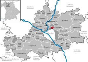
| Location of the community of Gundelsheim in the Bamberg district | ||
  |
||

Gundelsheim is a municipality in the Upper Franconian district of Bamberg .
geography
Geographical location
Gundelsheim is in the Upper Franconia-West region. The community is located around seven kilometers north of Bamberg at the Bamberg junction, the intersection of the A 70 and A 73 motorways . There are also two regional district road connections to the B 4 and to State Road 2190.
Community structure
There is only the district and the community part of Gundelsheim.
Neighboring communities
Neighboring communities are (starting from the north clockwise): Memmelsdorf , Bamberg and Hallstadt .
history
Until the church is planted
Gundelsheim belonged to the Bamberg monastery and from 1500 also to the Franconian Empire . Since the Reichsdeputationshauptschluss of 1803, the place, like large parts of Franconia, has belonged to Bavaria (see also History of Franconia ). In the course of the administrative reforms in the Kingdom of Bavaria , today's municipality was created with the municipal edict of 1818 .
20th century
In 1969 the Church of the Seven Sorrows of Mary was built in Gundelsheim.
Assignments
On July 1, 1972, the Hirschknock district was ceded to Bamberg.
Population development
In the period from 1988 to 2018, the community grew from 2911 to 3494 by 583 inhabitants or 20%.
- 1961: 1014 inhabitants, with Hirschknock 1122
- 1970: 1335 inhabitants, with Hirschknock 1454
- 1987: 2755 inhabitants
- 1991: 3074 inhabitants
- 1995: 3345 inhabitants
- 2000: 3339 inhabitants
- 2005: 3324 inhabitants
- 2010: 3272 inhabitants
- 2015: 3367 inhabitants
religion
According to the census on May 9, 2011, 67.7% of the residents of Gundelsheim are Roman Catholic and 18.9% Protestant. 13.4% have another religion or are non-denominational.
politics
mayor
Jonas Merzbacher (SPD) has been the first mayor since May 1, 2008 . At the age of 24 he was the second youngest mayor in Germany when he took office. In 2008 he won the runoff election with 68.23% of the votes against Norbert Mittmann (Free Voting Association) and was confirmed in the first ballot in 2014 and 2020 with 70.97% and 74.76%, respectively, with one opposing candidate in office. Merzbacher's predecessor was Hans-Jürgen Grieger (CSU). In 2002 he succeeded Gerhard Dorsch (Bürgergemeinschaft), who had been in office since 1990. Its predecessor was Michael Arneth (Bürgergemeinschaft) since 1972. The second mayor is Robert Martin (community of citizens).
Municipal council
In the 2014–2020 electoral period, the municipal council consists of the following parties and voter communities (in brackets 2008–2014):
- SPD 5 (4) seats
- CSU 5 (4) seats
- Citizens' community 3 (4) seats
- Free voter community 1 (2) seat (s)
- Green / Fresh Wind 2 (2) seats
coat of arms
|
|
Blazon : "Divided by black and gold, on the dividing line an upper golden glaze wheel and a lower black mill wheel." |
Culture and sights
Architectural monuments
Soil monuments
education
In Gundelsheim there is a kindergarten with 125 places and the elementary school with nine teachers and 136 students. The St. Marien day care center offers care in four groups, one of which is a crèche group for children aged between eight weeks and three years and three groups for children between the ages of two and six.
Honorary citizen
Jacobus Beck, O. Carm. (* March 9, 1905 in Hartenreuth ; † May 8, 1967 in Bamberg ), pastor for many years in Gundelsheim. Ex provincial , archbishop clerical council , director of the late- calling gymnasium Theresianums at the Carmelite monastery in Bamberg.
Economy and Infrastructure
The municipal tax revenue in 1999 was the equivalent of 1,565,000 euros, of which 232,000 euros were trade tax revenues (net).
Economy including agriculture and forestry
In 1998, according to official statistics, there were 101 employees in the manufacturing sector and 29 in the trade and transport sector at the place of work. In other economic areas, 68 people were employed at the place of work subject to social security contributions. There were a total of 1149 employees at the place of residence subject to social security contributions. There was one in the manufacturing sector and five in the construction sector. In addition, in 1999 there were three farms with an agricultural area of 23 hectares, of which 21 hectares were arable land and three hectares were permanent green space.
Breweries
There is no longer a brewery in Gundelsheim . The last was the Leicht brewery, which closed in 1959.
traffic
Gundelsheim had a stop on the Bamberg – Scheßlitz railway line , which was shut down in 1985 ( passenger traffic ) and 1988 ( freight traffic ) and then dismantled. The place has a city bus connection of the Stadtwerke Bamberg.
Web links
- Gundelsheim community
- Gundelsheim (Upper Franconia): Official statistics of the LfStat (PDF; 1.24 MB)
Individual evidence
- ↑ "Data 2" sheet, Statistical Report A1200C 202041 Population of the municipalities, districts and administrative districts 1st quarter 2020 (population based on the 2011 census) ( help ).
- ↑ Data around Gundelsheim. Community of Gundelsheim, accessed on August 23, 2020 .
- ↑ Johannes Neumann: The Reichsdeputationshauptschluss of 1803: Requirements and consequences (PDF file; 179 kB)
- ↑ Town Hall & Administration> Subject areas and areas of responsibility. Gundelsheim community, accessed on August 9, 2020 .
- ^ Entry on the coat of arms of Gundelsheim (Upper Franconia) in the database of the House of Bavarian History

Altendorf | Baunach | Bischberg | Breitengüßbach | Burgebrach | Burgwindheim | Buttenheim | Ebrach | Frensdorf | Gerach | Gundelsheim | Hallstadt | Heiligenstadt in Upper Franconia | Hirschaid | Kemmern | Koenigsfeld | Louder | Lisberg | Litzendorf | Memmelsdorf | Oberhaid | Pettstadt | Pommersfelden | Priesendorf | Rattelsdorf | Reckendorf | Scheßlitz | Key field | Schönbrunn im Steigerwald | Stadelhofen | Stegaurach | Strullendorf | Viereth-Trunstadt | Walsdorf | Wattendorf | Zapfendorf
Community-free areas
Ebracher Forst |
Eichwald |
Geisberger Forest |
Main Bog Forest |
Koppenwinder Forest |
Lindach |
Semberg |
Steinachsrangen |
Winkelhofer Forest |
Zückshuter Forest