
Lauter (Upper Franconia)
| coat of arms | Germany map | |
|---|---|---|

|
Coordinates: 49 ° 58 ' N , 10 ° 47' E |
|
| Basic data | ||
| State : | Bavaria | |
| Administrative region : | Upper Franconia | |
| County : | Bamberg | |
| Management Community : | Baunach | |
| Height : | 269 m above sea level NHN | |
| Area : | 12.4 km 2 | |
| Residents: | 1140 (Dec. 31, 2019) | |
| Population density : | 92 inhabitants per km 2 | |
| Postal code : | 96169 | |
| Area code : | 09544 | |
| License plate : | BA | |
| Community key : | 09 4 71 152 | |
| Community structure: | 6 districts | |
| Association administration address: | Bamberger Strasse 1 96148 Baunach |
|
| Website : | ||
| Mayor : | Ronny Beck ( CSU ) | |
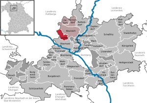
| Location of the community Lauter in the district of Bamberg | ||
  |
||

Lauter is a municipality in the Upper Franconian district of Bamberg and a member of the Baunach administrative community .
geography
Geographical location
The community is located in the region of Upper Franconia-West by the creek Lauter , in construction demand in the river Baunach flows.
Neighboring communities
Neighboring municipalities are (starting from the north clockwise): Baunach , Oberhaid , both districts of Bamberg , Stettfeld and Ebelsbach , both districts of Haßberge .
Community structure
Lauter is divided into six districts (with population figures, as of July 3, 2019):
- Appendorf (239)
- Deusdorf (275)
- Deusdorfermühle (6)
- Krappenhof (3)
- Louder (606)
- Leppelsdorf (72)
There are the districts Deusdorf, Lauter, Leppelsdorf and Appendorf.
history
Until the church is planted
In 1251, Pope Innocent IV confirmed the property and privileges of the Michelsberg Monastery in Lauter in a document. Lauter belonged to the bishopric of Bamberg and from 1500 to the Franconian Empire . The Counts of Truhendingen had their seat on the step castle near Lauter . Since the Reichsdeputationshauptschluss of 1803, the place, like large parts of Franconia, has belonged to Bavaria (see also History of Franconia ). In the course of the administrative reforms in the Kingdom of Bavaria , today's municipality was created with the municipal edict of 1818 .
Administrative affiliation
On July 1, 1972, Lauter came with all of its later districts from the dissolved district of Ebern to the district of Bamberg and thus from Lower to Upper Franconia .
Incorporations
On April 1, 1971, part of the former municipality of Appendorf was incorporated.
On May 1, 1978, the municipality officially renamed from Leppelsdorf to Deusdorf in 1875 came to Lauter.
Population development
In the period from 1988 to 2018, the municipality grew from 1,026 to 1,148 by 122 inhabitants or 11.9%.
- 1961: 1013 inhabitants
- 1970: 1000 inhabitants
- 1987: 1024 inhabitants
- 1991: 1072 inhabitants
- 1995: 1103 inhabitants
- 2000: 1124 inhabitants
- 2005: 1191 inhabitants
- 2010: 1135 inhabitants
- 2015: 1151 inhabitants
religion
According to the census on May 9, 2011, 80.0% of the population were Roman Catholic and 10.7% Evangelical Lutheran. 9.3% had another religion or were non-denominational.
politics
mayor
Mayor has been Ronny Beck (CSU) since May 1, 2020, who prevailed against Helmut Hartmann (Free Voters) with 52.70% of the vote. His predecessor was Armin Postler (CSU), who won in 2002 with 60.89% of the vote. In 2008 he was re-elected with 85.95% of the vote and in 2014 with 88.16%. In 2002, Postler succeeded Manfred Beierlieb (Free Voters), who won against Hans-Jürgen Zitzelsberger (CSU) in 1996 with 67.51% of the vote.
Municipal council elections
The local elections in 1996, 2002, 2008 and 2014 led to the following allocation of seats in the local council :
| 1996 | 2002 | 2008 | 2014 | |
|---|---|---|---|---|
| CSU | 6th | 7th | 7th | 8th |
| Free voters | 6th | 5 | 5 | 4th |
| total | 12 | 12 | 12 | 12 |
coat of arms
The description of the coat of arms reads: "Two silver flights in red, each with clad silver arms growing inwards, which hold the style of a vertical golden grate."
Architectural monuments
Economy and Infrastructure
Economy including agriculture and forestry
In 1998, according to official statistics, there were no employees at the place of work in the manufacturing industry or in the trade and transport sector. There were a total of 391 employees at the place of residence subject to social security contributions. There were two companies in the manufacturing sector and three in the construction sector. In addition, in 1999 there were 32 farms with an agricultural area of 315 hectares, of which 247 hectares were arable land and 67 hectares were permanent green areas.
Voluntary fire brigades
There are volunteer fire brigades in Appendorf, Deusdorf, Lauter and Leppelsdorf. The Lauter fire brigade has an LF 8 and an MZF .
Breweries
Today there is no longer a brewery in the area of Lauter. The Fößel brewery in the Appendorf district closed in 2016.
education
There is a kindergarten with 50 places (as of 1999).
sports clubs
Sports clubs are the SpVgg Lauter, whose football department plays in the district league, Bamberg / Bayreuth district, and the Keilschoner Deusdorf bowling club.
Individual evidence
- ↑ "Data 2" sheet, Statistical Report A1200C 202041 Population of the municipalities, districts and administrative districts 1st quarter 2020 (population based on the 2011 census) ( help ).
- ↑ http://www.bayerische-landesbibliothek-online.de/orte/ortssuche_action.html ? Anzeige=voll&modus=automat&tempus=+20111101/204626&attr=OBJ&val= 1121
- ↑ https://www.gemeinde-lauter.de/leben-wohnen/ortsteile/
- ↑ Johannes Neumann: The Reichsdeputationshauptschluss of 1803: Requirements and consequences (PDF file; 179 kB)
- ↑ a b Wilhelm Volkert (Ed.): Handbook of the Bavarian offices, communities and courts 1799–1980 . CH Beck, Munich 1983, ISBN 3-406-09669-7 , p. 453 .
- ^ Federal Statistical Office (ed.): Historical municipality directory for the Federal Republic of Germany. Name, border and key number changes in municipalities, counties and administrative districts from May 27, 1970 to December 31, 1982 . W. Kohlhammer GmbH, Stuttgart / Mainz 1983, ISBN 3-17-003263-1 , p. 673 .
Web links
- Entry on the coat of arms of Lauter (Upper Franconia) in the database of the House of Bavarian History
- Lauter (Upper Franconia): Official statistics of the LfStat (PDF; 1.24 MB)

Altendorf | Baunach | Bischberg | Breitengüßbach | Burgebrach | Burgwindheim | Buttenheim | Ebrach | Frensdorf | Gerach | Gundelsheim | Hallstadt | Heiligenstadt in Upper Franconia | Hirschaid | Kemmern | Koenigsfeld | Louder | Lisberg | Litzendorf | Memmelsdorf | Oberhaid | Pettstadt | Pommersfelden | Priesendorf | Rattelsdorf | Reckendorf | Scheßlitz | Key field | Schönbrunn im Steigerwald | Stadelhofen | Stegaurach | Strullendorf | Viereth-Trunstadt | Walsdorf | Wattendorf | Zapfendorf
Community-free areas
Ebracher Forst |
Eichwald |
Geisberger Forest |
Main Bog Forest |
Koppenwinder Forest |
Lindach |
Semberg |
Steinachsrangen |
Winkelhofer Forest |
Zückshuter Forest