Stettfeld
| coat of arms | Germany map | |
|---|---|---|

|
Coordinates: 49 ° 58 ' N , 10 ° 43' E |
|
| Basic data | ||
| State : | Bavaria | |
| Administrative region : | Lower Franconia | |
| County : | Hatred Mountains | |
| Management Community : | Ebelsbach | |
| Height : | 240 m above sea level NHN | |
| Area : | 11.16 km 2 | |
| Residents: | 1154 (Dec. 31, 2019) | |
| Population density : | 103 inhabitants per km 2 | |
| Postal code : | 96188 | |
| Area code : | 09522 | |
| License plate : | HAS, EBN, GEO , HOH | |
| Community key : | 09 6 74 201 | |
| Community structure: | 1 district | |
| Association administration address: | Georg-Schäfer-Str. 56 97500 Ebelsbach |
|
| Website : | ||
| Mayor : | Alfons Hartlieb jun. ( CSU ) | |
| Location of the municipality of Stettfeld in the Haßberge district | ||
Stettfeld is a municipality in the Lower Franconian district of Haßberge and a member of the Ebelsbach administrative community .
geography
The place is in the Haßberge , northwest of Bamberg . There is only the district of Stettfeld and the place of the same name. The Main flows past just under a kilometer to the southwest . He feeds numerous ponds there. To the north is the Stettfeld community forest. This is where the Stettfelder Mühlbach rises, which flows into the Main after flowing through the village.
Neighboring communities are (starting from the north clockwise): Ebelsbach , Lauter , Oberhaid and Eltmann .
history
Until the church is planted
As part of the high pin Würzburg Stettfeld was 1,803 in favor of Bavaria secularized , then in the Peace of Pressburg in 1805 Archduke Ferdinand of Tuscany to form the Grand Duchy of Wurzburg left with which it finally fell to Bayern 1814th
Population development
- 1840: 721 inhabitants
- 1871: 757 inhabitants
- 1900: 670 inhabitants
- 1925: 711 inhabitants
- 1939: 695 inhabitants
- 1950: 995 inhabitants
- 1961: 923 inhabitants
- 1970: 1036 inhabitants
- 1987: 1024 inhabitants
- 1991: 1087 inhabitants
- 1995: 1210 inhabitants
- 2000: 1294 inhabitants
- 2005: 1260 inhabitants
- 2010: 1204 inhabitants
- 2015: 1145 inhabitants
politics
Municipal council
The municipal council of Stettfeld (excluding the mayor) has twelve members.
| Parties / voter communities |
% 2020 |
Seats 2020 |
% 2014 |
Seats 2014 |
% 2008 |
Seats 2008 |
% 2002 |
Seats 2002 |
|
| CSU | Christian-Social Union in Bavaria | 35.8 | 4th | 51.0 | 6th | 44.9 | 5 | 43.1 | 5 |
| SPD | Social Democratic Party of Germany | 19.6 | 2 | 20.9 | 3 | 24.7 | 3 | 39.6 | 5 |
| Stettfeld village community | 44.6 | 6th | 28.0 | 3 | 30.4 | 4th | 17.3 | 2 | |
| total | 100 | 12 | 100 | 12 | 100 | 12 | 100 | 12 | |
| Voter turnout in% | 79.8 | 76.4 | 79.8 | 72.2 | |||||
mayor
Alfons Hartlieb (CSU), born in 1961, has been the mayor since November 21, 2005. He was confirmed in office on March 16, 2014 with 62.7 percent of the votes and in the runoff election on March 29, 2020 with 52.5% of the votes.
coat of arms
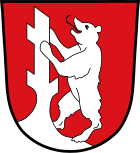
The description reads: "In red an upright silver bear climbing up a silver tree stump".
Architectural monuments
Economy and Infrastructure
Economy including agriculture and forestry
In 1998, according to official statistics, there were 109 in the manufacturing industry and in the trade and transport sector no employees subject to social security contributions at the place of work. There were a total of 446 employees at the place of residence subject to social security contributions. There was one company in the manufacturing sector and two companies in the construction sector. In addition, in 1999 there were 20 farms with an agriculturally used area of 577 hectares (ha), of which 469 hectares were arable land and 107 hectares were permanent green space.
traffic
State road 2277 crosses Stettfeld . It leads via Eltmann to the A 70 motorway, which runs about 600 m to the south (exit AS 12 Eltmann ).
The Bamberg – Würzburg railway line runs parallel to the A 70, with stations in Eltmann and Oberhaid .
The Franconian Marienweg runs through Stettfeld .
education
There is the following facility:
- Kindergartens: Caritas Kindergarten St. Johannes, Gartenstrasse 7, with 50 kindergarten places and 10 places for crèche children. According to official statistics, 65 children were cared for on March 1, 2018.
Culture
In Stettfeld there is a music and a choral society that give several concerts a year. The Stettfelder Freilichtbühne theater group performs at least one play every year either as an indoor play or as an open-air production in the courtyard of the old mill. The Stettfeld History Working Group has been running a local history museum with changing exhibitions since 2007.
Individual evidence
- ↑ "Data 2" sheet, Statistical Report A1200C 202041 Population of the municipalities, districts and administrative districts 1st quarter 2020 (population based on the 2011 census) ( help ).
- ↑ Bavarian State Office for Statistics: Statistics communal 2015 - a selection of important statistical data: Municipality of Stettfeld 09 674 201 . Ed .: Bavarian State Office for Statistics. Bavarian State Office for Statistics, Munich July 31, 2016, p. 28 .
- ↑ Result of the 2020 local elections
- ↑ Result of the 2014 local elections
- ^ Result of the 2008 local elections
- ^ Result of the local elections in 2002
- ^ Deutscher Caritasverband eV: Address. November 4, 2014, accessed August 18, 2017 .
Web links
- Entry on the coat of arms of Stettfeld in the database of the House of Bavarian History


