
Administrative community Ebelsbach
| coat of arms | Germany map | |
|---|---|---|

|
Coordinates: 49 ° 59 ' N , 10 ° 41' E |
|
| Basic data | ||
| Existing period: | 1978– | |
| State : | Bavaria | |
| Administrative region : | Lower Franconia | |
| County : | Hatred Mountains | |
| Area : | 66.23 km 2 | |
| Residents: | 7234 (Dec. 31, 2019) | |
| Population density : | 109 inhabitants per km 2 | |
| License plate : | HAS, EBN, GEO , HOH | |
| Association key : | 09 6 74 5610 | |
| Association structure: | 4 municipalities | |
| Association administration address : |
Georg-Schäfer-Str. 56 97500 Ebelsbach |
|
| Website : | ||
| Chairman of the administrative association : | Walter Ziegler | |
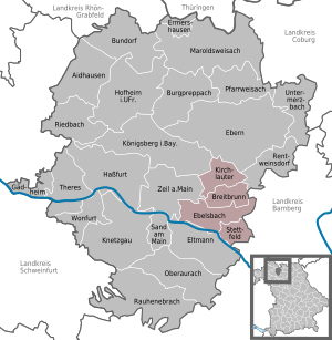
| Location of the Ebelsbach administrative community in the Haßberge district | ||
  |
||

In the administrative community Ebelsbach in the Lower Franconian district of Haßberge , the following communities have come together to handle their administrative business:
- Breitbrunn , 1023 inhabitants, 12.4 km²
- Ebelsbach , 3749 inhabitants, 25.76 km²
- Kirchlauter , 1308 inhabitants, 16.91 km²
- Stettfeld , 1154 inhabitants, 11.16 km²
The administrative association is based in Ebelsbach .
Individual evidence
- ↑ "Data 2" sheet, Statistical Report A1200C 202041 Population of the municipalities, districts and administrative districts 1st quarter 2020 (population based on the 2011 census) ( help ).