
Administrative community Ebern
| coat of arms | Germany map | |
|---|---|---|

|
Coordinates: 50 ° 5 ' N , 10 ° 48' E |
|
| Basic data | ||
| Existing period: | 1978– | |
| State : | Bavaria | |
| Administrative region : | Lower Franconia | |
| County : | Hatred Mountains | |
| Area : | 148.08 km 2 | |
| Residents: | 10,387 (Dec. 31, 2019) | |
| Population density : | 70 inhabitants per km 2 | |
| License plate : | HAS, EBN, GEO , HOH | |
| Association key : | 09 6 74 5611 | |
| Association structure: | 3 municipalities | |
| Association administration address : |
Rittergasse 3 96106 Ebern |
|
| Website : | ||
| Chairman of the administrative association : | Jürgen Hennemann (SPD) | |
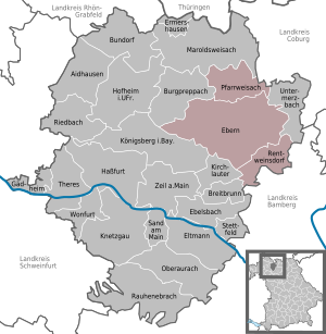
| Location of the Ebern administrative community in the Haßberge district | ||
  |
||

In the administrative community Ebern in the Lower Franconian district of Haßberge , the following communities have come together to handle their administrative business:
- Ebern , town with 7317 inhabitants, 95.02 km²
- Pfarrweisach , 1472 inhabitants, 28.44 km²
- Rentweinsdorf , market , population 1598, 24.62 km²
The administrative community is based in Ebern.
The community of Untermerzbach , originally the fourth member, was released from the administrative community on January 1, 1994 at their request.
Individual evidence
- ↑ "Data 2" sheet, Statistical Report A1200C 202041 Population of the municipalities, districts and administrative districts 1st quarter 2020 (population based on the 2011 census) ( help ).
- ↑ Fourth law to change the structure of municipalities and administrative communities of November 9, 1993 ( GVBl p. 830)