
Untermerzbach
| coat of arms | Germany map | |
|---|---|---|

|
Coordinates: 50 ° 8 ' N , 10 ° 52' E |
|
| Basic data | ||
| State : | Bavaria | |
| Administrative region : | Lower Franconia | |
| County : | Hatred Mountains | |
| Height : | 264 m above sea level NHN | |
| Area : | 27.75 km 2 | |
| Residents: | 1703 (Dec. 31, 2019) | |
| Population density : | 61 inhabitants per km 2 | |
| Postal code : | 96190 | |
| Area code : | 09533 | |
| License plate : | HAS, EBN, GEO , HOH | |
| Community key : | 09 6 74 210 | |
| Community structure: | 13 districts | |
| Address of the municipal administration: |
Marktplatz 8 96190 Untermerzbach |
|
| Website : | ||
| Mayor : | Helmut Dietz ( SPD ) | |
| Location of the community of Untermerzbach in the Haßberge district | ||
  |
||


Untermerzbach is a municipality in the Haßberge district in Lower Franconia .
geography
location
Untermerzbach is located in the Main-Rhön region in the Lower Franconian part of the Itzgrund .
Community structure
The 13 districts (population in brackets: as of January 2009) are:
|
|
The following districts exist : Gereuth, Gleusdorf, Hemmendorf, Memmelsdorf in Lower Franconia, Obermerzbach, Untermerzbach, Wüstenwelsberg, Recheldorf, Buch.
Neighboring communities
Neighboring communities are (starting from the north clockwise): Itzgrund , Rattelsdorf , Rentweinsdorf , Ebern , Pfarrweisach and Seßlach .
history
Until the 19th century
Untermerzbach was first mentioned in a document in 1232 when "Mercebach" was parish off to Ebern . In 1369 Lutz von Rotenhan received three tithe . Under Kunz II von Rotenhan, Untermerzbach became Protestant in 1534. In 1675 Georg Wolf von Rotenhan returned to the Catholic Church. Untermerzbach Castle , which was redesigned in the early Classicist style in the second half of the 18th century , belonged to the Counts of Rotenhan until it died out in 1886.
All rights of the Hochstift Bamberg with the Abbey of Langheim , the Freiherr en von Greiffenclau and the Counts von Rotenhan fell to Bavaria between 1803 and 1806. In the course of border adjustments, the place was given to the Grand Duchy of Würzburg in 1810 and finally became part of Bavaria in 1814/16. In the district of Gereuth is the former prince-bishop's country palace of the same name , which came into the possession of the barons Hirsch auf Gereuth in 1815 in the course of secularization (until 1859).
Incorporations
On April 1, 1971, the independent towns of Gereuth, Obermerzbach and Wüstenwelsberg, which were independent from 1818, were incorporated. On May 1, 1978 Gleusdorf, Memmelsdorf in Lower Franconia and areas of the dissolved communities Lichtenstein and Recheldorf were added.
Population development
- 1961: 2133 inhabitants
- 1970: 1960 inhabitants
- 1987: 1757 inhabitants
- 1991: 1883 inhabitants
- 1995: 1846 inhabitants
- 2000: 1895 inhabitants
- 2005: 1773 inhabitants
- 2010: 1713 inhabitants
- 2015: 1696 inhabitants
politics
Municipal council
The municipal council of Untermerzbach has 13 members including the full-time mayor.
| CSU | SPD | Civic bloc | Dedicated voter community | total | |
| 2014 | 4th | 5 | 4th | - | 13 seats |
| 2008 | 4th | 5 | 3 | 1 | 13 seats |
mayor
Helmut Dietz (SPD) from Memmelsdorf in Lower Franconia has been mayor since May 1, 2008. In 2008 he won the election with 62.00% of the vote against Edgar Maier (CSU). His predecessor was Walter Eichhorn (Free Voters), who no longer ran for reasons of age. Eichhorn retired on April 30, 2008 after 56 years of service in the public service, presumably the longest-serving civil servant in the Free State of Bavaria. In 2014, Helmut Dietz was re-elected with approx. 94% of the votes unopposed and was confirmed in office for another six years on March 15, 2020 with 71.8% of the votes.
coat of arms
The description reads: "Above a silver wavy bar in green, two intertwined golden snakes each bursting out of the edge of the shield, above which a silver cross hovers."
Culture and sights

St. Michael Obermerzbach

Parish church Untermerzbach
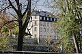
Untermerzbach Castle

Gleusdorf Castle

Gereuth Castle

Memmelsdorf synagogue


- Filial church St. Michael Obermerzbach
- Parish church Untermerzbach , since 1691 a simultaneous church
- Untermerzbach Castle
- Gleusdorf Castle
- Gereuth Castle
- Gleusdorf Synagogue
- Memmelsdorf synagogue
- Jewish cemetery Memmelsdorf
- Jewish cemetery Untermerzbach
Monuments
Architectural monuments
Soil monuments
Natural monument Hunneneiche


The pedunculate oak, designated as a natural monument since 1963 , with a chest height of 6.70 m (2020) is located on the southwestern edge of the village, just outside the development, directly on the roadside. The age of the monumental oak is given as around 300 years. Its cylindrical trunk is hollow on the inside and only branches out into a multi-branched crown at a height of about 10 meters. Individual branches branch off from the emerging trunk beforehand in the course of growth. The tree reaches a height of 21 meters with a crown diameter of 16 meters.
Economy and Infrastructure
Economy including agriculture and forestry
In 2017, according to official statistics, there were 1,072 employees subject to social security contributions at the place of work. Of the resident population, 672 people were in employment subject to social security contributions, so that the number of inbound commuters was 400 higher than that of outbound commuters. In 2016 there were 16 farms, in 1999 there were 55. 1624 hectares were used for agriculture, of which 1278 hectares were arable land and 376 hectares were permanent green areas.
traffic
Untermerzbach is on federal highway 4 , which connects Bamberg with Coburg . From 1913 Untermerzbach was connected to the railway network with the Kaltenbrunn-Untermerzbach station on the Breitengüßbach – Dietersdorf railway line. Passenger traffic ended in 1975, in 1981 the line was closed and then dismantled.
education
In 2018 there were the following institutions:
- A day-care center for children with 62 places and 55 children, including 27 under three years of age
- An elementary school with three teachers, two classes and 49 students
Personalities
- Bernhard Solger (born December 5, 1849 in Untermerzbach, † February 21, 1935 in Neisse), anatomist and university professor
- Margarete Müller-Henning (born May 8, 1924 in Kiev; † February 8, 2015 at Schloss Gleusdorf, Untermerzbach), writer, poet and interpreter, most recently lived in Schloss Gleusdorf retirement home.
See also the corresponding entries in the Memmelsdorf district in Lower Franconia .
Individual evidence
- ↑ "Data 2" sheet, Statistical Report A1200C 202041 Population of the municipalities, districts and administrative districts 1st quarter 2020 (population based on the 2011 census) ( help ).
- ↑ http://www.bayerische-landesbibliothek-online.de/orte/ortssuche_action.html ? Anzeige=voll&modus=automat&tempus=+20111025/164346&attr=OBJ&val= 1645
- ^ Werner Schmiedel: Districts Ebern and Hofheim . Historical book of place names of Bavaria. Lower Franconia. Volume 2: Districts of Ebern and Hofheim. Commission for Bavarian History, Munich 1973, ISBN 3 7696 9872 X . P. 35
- ^ Wilhelm Volkert (ed.): Handbook of Bavarian offices, communities and courts 1799–1980 . CH Beck, Munich 1983, ISBN 3-406-09669-7 , p. 453 .
- ↑ a b c Federal Statistical Office (ed.): Historical municipality directory for the Federal Republic of Germany. Name, border and key number changes in municipalities, counties and administrative districts from May 27, 1970 to December 31, 1982 . W. Kohlhammer GmbH, Stuttgart / Mainz 1983, ISBN 3-17-003263-1 , p. 760 and 761 .
- ^ Entry in the directory of monumental oaks . Retrieved August 4, 2020
Web links
- Entry on the coat of arms of Untermerzbach in the database of the House of Bavarian History

Aidhausen | Breitbrunn | Bundorf | Burgpreppach | Ebelsbach | Boars | Eltmann | Ermershausen | Gädheim | Hassfurt | Hofheim in Lower Franconia | Kirchlauter | Knetzgau | Königsberg in Bavaria | Maroldsweisach | Oberaurach | Pfarrweisach | Rauhenebrach | Rentweinsdorf | Riedbach | Sand am Main | Stettfeld | Theres | Untermerzbach | Wonfurt | Zeil am Main