
Bundorf
| coat of arms | Germany map | |
|---|---|---|

|
Coordinates: 50 ° 13 ' N , 10 ° 31' E |
|
| Basic data | ||
| State : | Bavaria | |
| Administrative region : | Lower Franconia | |
| County : | Hatred Mountains | |
| Management Community : | Hofheim in Lower Franconia | |
| Height : | 325 m above sea level NHN | |
| Area : | 40.24 km 2 | |
| Residents: | 888 (Dec 31, 2019) | |
| Population density : | 22 inhabitants per km 2 | |
| Postal code : | 97494 | |
| Primaries : | 09763, 09523 | |
| License plate : | HAS, EBN, GEO , HOH | |
| Community key : | 09 6 74 120 | |
| LOCODE : | DE UN5 | |
| Community structure: | 6 districts | |
| Association administration address: | Obere Sennigstr. 4 97461 Hofheim i.UFr. |
|
| Website : | ||
| Mayor : | Hubert Endres ( Free Voters ) | |
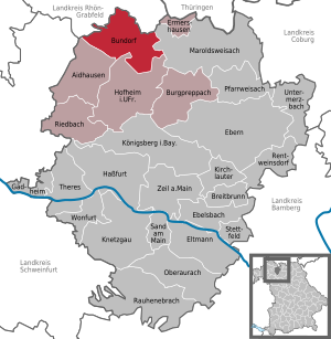
| Location of the municipality of Bundorf in the Haßberge district | ||
  |
||

Bundorf is a municipality in the Lower Franconian district of Haßberge and a member of the administrative community Hofheim in Lower Franconia . With a population density of only 22 inhabitants per km² today, the municipality is one of the most sparsely populated areas in western Germany.


geography
Geographical location
The main town is in the Main-Rhön region ( Bavarian planning region 3), just under 30 km northeast of Schweinfurt . In the village the Rippbach flows into the Baunach , a right tributary of the Main .
Community structure
There are six districts:
|
|
Then there are the three solitudes Hellers-, top and Seemühle. There are the districts Bundorf, Kimmelsbach, Neuses, Schweinshaupten, Stöckach, Walchenfeld and Rottensteiner Forst.
Neighboring communities
Neighboring communities are (starting from the north clockwise): Sulzdorf an der Lederhecke , Maroldsweisach , Hofheim in Lower Franconia and Aidhausen .
history
Until the church is planted
The first documentary mention was in 1170, when the Ebrach monastery and the Würzburg monastery exchanged goods in "Buntdorf". The Würzburg bishopric and the Truchseß von Wetzhausen family, who had occupied the Bundorf manor since 1343, shared rulership. The rights of the bishopric, which had been secularized in favor of Bavaria , fell in 1805, those of the manor in 1806 with mediatization to the Grand Duchy of Würzburg , which became part of Bavaria in 1814 . In the course of the administrative reforms in Bavaria, the municipality of Bundorf was created with the municipal edict of 1818 .
Incorporations
On May 1, 1978, the formerly independent communities of Kimmelsbach, Neuses, Schweinshaupten, Stöckach and Walchenfeld were incorporated.
Population development
- 1961: 1379 inhabitants
- 1970: 1323 inhabitants
- 1987: 1050 inhabitants
- 1991: 1042 inhabitants
- 1995: 1009 inhabitants
- 2000: 1011 inhabitants
- 2005: 973 inhabitants
- 2010: 901 inhabitants
- 2015: 919 inhabitants
politics
Municipal council
The municipal council has nine members including the part-time mayor. After the merger of the Christian voter community and the Free Voters, there was only one party left to take part in the 2014 elections.
| Christian voter community / free voters | total | |
| 2014 | 9 | 9 seats |
| Christian voter community | Free voters | total | |
| 2008 | 7th | 6th | 13 seats |
mayor
Hubert Endres (Free Voters) has been mayor since 2008. He won the election against the then incumbent Richard Schmitt (Christian voter community). In 2014, he was re-elected with around 73% of the vote, with no opposing candidate. Due to the merger in 2014, he is now part of the merger (Christian voter community / Free voters). In 2020 he was re-elected for six years with 81.3% of the vote.
coat of arms
|
|
Blazon : "In gold, six, three-to-one, vertical green oak leaves, in between a raised beam of red and silver in two rows and a lowered red wavy beam." |
Monuments
Architectural monuments

Soil monuments
Economy and Infrastructure
Economy including agriculture and forestry
The municipal tax receipts amounted to the equivalent of 316,000 euros in 1999, of which 22,000 euros (net) were trade tax receipts. In 1998, according to official statistics, there were 27 employees at the place of work in the manufacturing sector and six in the trade and transport sector. There were a total of 343 employees at the place of residence subject to social security contributions. There were three companies in the manufacturing sector and one in the construction sector. In addition, there were 48 farms in 1999 with an agricultural area of 2013 hectares, of which 1660 hectares were arable land and 353 hectares were permanent green space.
education
In 1999 the following institutions existed:
- 50 kindergarten places with 55 children
literature
- Georg Ludwig Lehnes: History of the Baunachgrund in Lower Franconia. Self-published, Würzburg 1842.
Web links
Individual evidence
- ↑ "Data 2" sheet, Statistical Report A1200C 202041 Population of the municipalities, districts and administrative districts 1st quarter 2020 (population based on the 2011 census) ( help ).
- ↑ Mayor / City Council. Bundorf municipality, accessed on June 2, 2020 .
- ^ Location database of the Bayerische Landesbibliothek Online, accessed on September 18, 2016.
- ^ Werner Schmiedel: Districts Ebern and Hofheim . Historical book of place names of Bavaria. Lower Franconia. Volume 2: Districts of Ebern and Hofheim. Commission for Bavarian State History, Munich 1973, ISBN 3-7696-9872-X . P. 65.
- ↑ a b c Federal Statistical Office (ed.): Historical municipality directory for the Federal Republic of Germany. Name, border and key number changes in municipalities, counties and administrative districts from May 27, 1970 to December 31, 1982 . W. Kohlhammer GmbH, Stuttgart / Mainz 1983, ISBN 3-17-003263-1 , p. 760 .
- ^ Entry on Bundorf's coat of arms in the database of the House of Bavarian History

Aidhausen | Breitbrunn | Bundorf | Burgpreppach | Ebelsbach | Boars | Eltmann | Ermershausen | Gädheim | Hassfurt | Hofheim in Lower Franconia | Kirchlauter | Knetzgau | Königsberg in Bavaria | Maroldsweisach | Oberaurach | Pfarrweisach | Rauhenebrach | Rentweinsdorf | Riedbach | Sand am Main | Stettfeld | Theres | Untermerzbach | Wonfurt | Zeil am Main