
Knetzgau
| coat of arms | Germany map | |
|---|---|---|

|
Coordinates: 49 ° 59 ' N , 10 ° 33' E |
|
| Basic data | ||
| State : | Bavaria | |
| Administrative region : | Lower Franconia | |
| County : | Hatred Mountains | |
| Height : | 238 m above sea level NHN | |
| Area : | 61.59 km 2 | |
| Residents: | 6485 (Dec. 31, 2019) | |
| Population density : | 105 inhabitants per km 2 | |
| Postal code : | 97478 | |
| Primaries : | 09527, 09529 , 09528 | |
| License plate : | HAS, EBN, GEO , HOH | |
| Community key : | 09 6 74 163 | |
| LOCODE : | DE ZKU | |
| Community structure: | 9 districts | |
| Address of the municipal administration: |
Am Rathaus 2 97478 Knetzgau |
|
| Website : | ||
| Mayor : | Stefan Paulus ( SPD / CWG ) | |
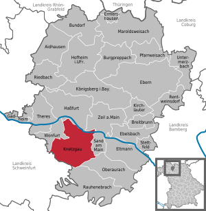
| Location of the municipality of Knetzgau in the Haßberge district | ||
  |
||

Knetzgau is a municipality in the Haßberge district in the east of the Bavarian administrative district of Lower Franconia .
geography
location
Knetzgau is located on the northern edge of the Steigerwald Nature Park at an altitude of about 238 m above sea level. NN . It is located on the Main , about five kilometers southeast of Haßfurt on the edge of the Haßberge .
Neighboring communities
The neighboring communities are (starting from the north clockwise): Haßfurt , Zeil am Main , Sand am Main , Oberaurach , Donnersdorf and Wonfurt .
structure
Knetzgau is divided into nine districts:
history
The first written mention took place around the year 780 in the Ilbicschen deed of donation, in which the place is mentioned under the name Knetzcegewe. Knetzgau was part of the Zeil office of the Bamberg bishopric , which from 1500 belonged to the Franconian Empire and fell to Bavaria in the Reichsdeputationshauptschluss 1803. In the course of border adjustments, the Zeil office became part of the Grand Duchy of Würzburg and finally Bavaria in 1814.
The moated castle Knetzgau was located in Schloßweg 12 .
On January 1, 1973, the previously independent community of Wohnau was incorporated. On July 1, 1974 Eschenau, Westheim near Haßfurt and Zell am Ebersberg were added. Larger areas of the dissolved municipality of Hainert followed on January 1, 1976.
politics


Municipal council
The following distribution of seats resulted in the local elections in recent years:
| Party / list | Seats 1996 | Seats 2002 | Seats 2008 | Seats 2014 |
|---|---|---|---|---|
| CSU | 7th | 8th | 6th | 6th |
| SPD | 3 | 3 | 3 | 3 |
| Christian voter community | 5 | 4th | 5 | 5 |
| Boy list | 2 | 2 | 2 | 2 |
| People interested in shared flatsR | 1 | 1 | - | - |
| Responsible citizens | 1 | 2 | 2 | - |
| FDP | - | - | 2 | 3 |
| Green / ecological list | - | - | - | 1 |
| total | 20th | 20th | 20th | 20th |
mayor
- 1972–1990 Franz Hofmann (CSU)
- 1990-2008 Werner Schneider (CSU)
- since 2008 Stefan Paulus (SPD / CWG)
Parts of the municipality with population figures
| Part of the community | Population 2008 * | Population 2006 * | |
|---|---|---|---|
| Knetzgau | 3,520 | 3,568 | |
| Eschenau | 180 | 193 | |
| Hainert | 338 | 337 | |
| Oberschwappach | 542 | 543 | |
| Unterschwappach | 163 | 172 | |
| Westheim | 869 | 885 | |
| Wohnau | 99 | 98 | |
| Zell am Ebersberg | 765 | 786 | |
| total | 6,476 | 6,582 |
* December 31st
Inhabitants of the entire municipality of Knetzgau with all districts on July 1, 2015: 6770.
Parish partnership
Since 1990 Knetzgau has maintained a partnership with the community of Gleichamberg in the Hildburghausen district, Thuringia.
Education, culture and social issues
- There are five kindergartens and after-school care centers as well as a primary and secondary school at educational institutions. Adult education center and community library complete the educational offer.
- Parishes exist in Eschenau and Westheim for Evangelical Lutheran believers and in Knetzgau for Catholics.
- There are two facilities for elderly care in the community.
- A multi-purpose hall and an indoor swimming pool are available for leisure and sport
Sights and monuments
- Oberschwappach Castle
- Steigerwaldrand
- Main lock Knetzgau
- Parish Church of St. Bartholomew, Knetzgau
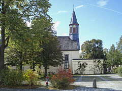
- Siechkapelle
- Böhlgrund Zell am Ebersberg
- Schloßberg Zell am Ebersberg, vineyard with the remains of a castle wall
- Architectural monuments
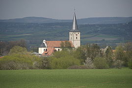
Knetzgau, parish church of St. Bartholomew
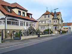
The main street in Knetzgau

Schelch monument , Main bridge near Knetzgau

St. Wendelin

Westheim

Eschenau

Trinity Church Eschenau

St. Barbara Oberschwappach

Unterschwappach
Hainert

Wohnau


Transport links
- Knetzgau is located south of the navigable river Main .
- It is three kilometers to the B 26 .
- The A 70 motorway ( Bayreuth –Schweinfurt) is one kilometer away (separate exit).
- It is five kilometers to the Bamberg – Würzburg railway line (Zeil station); It is just as far to Haßfurt train station, but more convenient in terms of transport.
Special events
- In 2009 the Bayern-3 -Dorffest took place in Knetzgau .
literature
- Karl Bosl : Knetzgau in opposition to the rulers and social forces, especially in the early modern period. Knetzgau community, Knetzgau 1980.
- Rainer Wailersbacher: 1200 years of Knezcegewe - Knetzgau. Hassfurt 1980.
- Rainer Wailersbacher: From the contents of the tower ball certificates from 1817 Dr. Johann Heinrich Keßler and his time: "Brief description of the most important events that took place at the time of the reconstruction of the Knetzgau church tower". Knetzgau community, Knetzgau 1980.
- Rainer Wailersbacher: Seven hundred years of Swapach - Eschenawe - Wunnawe Ober-, Unterschwappach, Eschenau, Wohnau. Knetzgau community, Knetzgau 1986.
- Rainer Wailersbacher: Oberschwappach Castle. Hausmüller, Zeil a. Main 1992.
- 750 years of the parish of St. Bartholomäus Knetzgau 1244–1994. Ed .: Catholic Parish Office Knetzgau. Ed .: William Thomas; Manfred Glass. Parish Saint Bartholomew, Knetzgau 1994.
- Rainer Wailersbacher: The Peasants' War in Knetzgau. Knetzgau municipality, Knetzgau 2000.
- Rainer Wailersbacher: The Knetzgau cemetery and its stations of the cross. Knetzgau community, Knetzgau 2001.
- Rainer Wailersbacher, Leo Maag: The Knetzgau street names - a local history. Knetzgau community, Knetzgau 2002.
- Rainer Wailersbacher: The Knetzgau first notarization of 911. Knetzgau municipality, Knetzgau 2005.
Web links
- District of Hainert
- Entry on the Knetzgau coat of arms in the database of the House of Bavarian History
Individual evidence
- ↑ "Data 2" sheet, Statistical Report A1200C 202041 Population of the municipalities, districts and administrative districts 1st quarter 2020 (population based on the 2011 census) ( help ).
- ↑ bayerische-landesbibliothek-online.de
- ^ Federal Statistical Office (ed.): Historical municipality directory for the Federal Republic of Germany. Name, border and key number changes in municipalities, counties and administrative districts from May 27, 1970 to December 31, 1982 . W. Kohlhammer GmbH, Stuttgart / Mainz 1983, ISBN 3-17-003263-1 , p. 758 and 759 .
Eschenau | Hainert | Knetzgau | Neuhaus | Oberschwappach | Unterschwappach | Westheim | Residential | Zell am Ebersberg

Aidhausen | Breitbrunn | Bundorf | Burgpreppach | Ebelsbach | Boars | Eltmann | Ermershausen | Gädheim | Hassfurt | Hofheim in Lower Franconia | Kirchlauter | Knetzgau | Königsberg in Bavaria | Maroldsweisach | Oberaurach | Pfarrweisach | Rauhenebrach | Rentweinsdorf | Riedbach | Sand am Main | Stettfeld | Theres | Untermerzbach | Wonfurt | Zeil am Main