
Zell am Ebersberg

Zell am Ebersberg is a district of the municipality of Knetzgau in the Haßberge district in Bavaria with almost 790 inhabitants.
geography
The Lower Franconian wine-growing village lies at the foot of the Ebersberg at approx. 280 m above sea level. NN . The Ebersberg is already visible from a distance, from the Main valley, approx. 450 m above sea level. NN high mountain, which is marked by a radio mast. On the Schloßberg (approx. 365 m above sea level ) there is a castle ruin and the Böhlgrund , the "gateway to the Steigerwald ". The Böhlbach , which rises in the Böhlgrund and flows into the Main between Knetzgau and Sand am Main , flows through Zell . Schloßberg and Hohe Lohe offer panoramic views over the Main Valley . Neighborhoods are Knetzgau , Sand am Main and Oberschleichach . To the east of the village is the new Knetzberge-Böhlgrund natural forest .
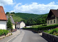 Zell with Ebersberg
 Marienkirche
 Böhlgrund
 Böhlgrund


history
Zell owes its origins to the Franconian traffic route between Bamberg and Schweinfurt . The first written mention of the place comes from the year 1111, but it is very likely that the place was settled a few centuries earlier. A castle on the Ebersberg was already mentioned in 1011, Burgstall Ebersberg . The traffic route was referred to as Königsweg or Rennsteig as far as Zell . From Zell this route ran on the ridge of the ridge between the Main and the northern Aurach as an elevated road. This was an important link between the Archdiocese of Bamberg and the Diocese of Würzburg . The castle ( Ebersberg castle ruins ) on the Schloßberg, built in 1115 by Bishop Otto von Bamberg , was probably used as a lodging and resting station for the clergy of the two dioceses of Würzburg and Bamberg, but was also the seat of the bailiffs for the administration of the episcopal property around Zell, them the lower courts were also responsible . The castle was also used as a customs post. The transport and carts that were on the Rennsteig had to pay their toll to officials of the diocese in Zell . The castle on the Schloßberg was burned down for the first time in 1525 by the farmers under Hans Luft, after which it was rebuilt. In 1634 the castle was finally destroyed by Swedish units in the Thirty Years War . Until the beginning of the 20th century, the remains of the walls and stone remains of the palace or castle were used to build houses by poor Zell farmers. In 1972 the castle area was expanded and made a lookout point by the Steigerwald Nature Park . In the present there are only a few remains of the walls and foundations.
On July 1, 1974, the previously independent municipality of Zell am Ebersberg was incorporated into the municipality of Knetzgau.
religion
The majority of the Zell population is Roman Catholic . In addition to the Catholic Church, Zell also has its own pastor's house and a parish home, which has been used as accommodation for Ukrainian refugees since 2015 . From a catholic point of view, Zell belongs to the parish administration to Knetzgau, Protestant to Westheim.
Public facilities
- Cemetery on Sanderstrasse
- Kindergarten in the old school building, right next to the church (built in 1877)
- Parish home, formerly called youth home
Culture & sights
- Catholic Church for the Immaculate Conception of Mary . In the 1970s, the existing church, which was in need of renovation, was torn down, only the steeple remained. A new modern church was built on the property
- Wall remains of Ebersberg Castle on the Schlossberg; built in 1115, destroyed in 1525 and 1634
- Remnants of the foundations of Heidenschloß in Böhlgrund (where the probably oldest chess pieces in Europe were found); mentioned in 1011, destroyed in 1525, 1644 and also afterwards
- Böhlgrund (northeastern gate of the Steigerwald)
- Schloßberg and Hohe Lohe offer views over the Main Valley to Schweinfurt
- Ebersberg (with a former sports facility)
- Royal oak in the Böhlgrund
- Barrows the Celts (between Zell am Ebersberg, Castle Hill and Oberschleichach)
- Oversized chess piece directly on the Böhlbach in the main street Sanderstraße junction, replica of the find at the Heidenschloß in Böhlgrund
- Former poor house in Zell am Ebersberg (now Rippstein Heckenwirtschaft)
- Schlangenweg (hiking route and mountain bike trail in Böhlgrund)
people
- Franziska Endres , from the Weiki-Hof in Zell am Ebersberg, was crowned Franconian Apple Queen on October 11, 2009, and her term of office is two years.
- Werner Schneider (CSU) from Zell was first mayor of the large municipality of Knetzgau from 1990 to 2008, and until 2014 district councilor in the Haßberge district
- Paul Hinz , teacher, historian and hobby archeologist, worked as a teacher in Zell, later rector of the Knetzgau elementary school. He undertook a lot of research and excavations around Zell am Ebersberg and advocated history, e.g. B. the Schloßberg, the Heidenschloss and the barrows
- Willi Fuß (CSU) from 2008 to 2014 second mayor of the Knetzgau community
Events
- The sports club TSV 1947 Zell am Ebersberg e. V. celebrated its 60th anniversary in 2007.
- The Musikverein 1972 Zell am Ebersberg celebrated its 40th anniversary in 2012, combined with the community and district music festival from June 30th to July 2nd, 2012 on the grounds of TSV Zell
- Zeller Büttensitzung takes place three times a year under the leadership of the Elferrat President with performances by the Zeller Elferrat, various dance guards, the TSV men's ballet, the Drei Zeller Originals and many other actors.
- Parish fair (second weekend in September): In Zell, the parish fair begins on Thursday with a beer tasting together with the brewery and the showmen. From Friday to Tuesday there is a festival in the sports center, on whose parking lot a small fairground is set up. On Saturday morning the Kerwasburm go into the forest to fetch the church fair tree and Maierli (small birch trees). In the afternoon they move from restaurant to restaurant together with the Musikverein 1972 Zell Zeller musicians to set up the Maierli in front of the house. The Federweiss era traditionally begins with the parish fair in Zell .
- Numerous events at the Heckenwirtschaften (Hofschoppenfeste, summer festivals, jazz brunch etc.)
- Maypole set up behind the church by the fire brigade, every April 30th
- Oktoberfest with Zeller Federweißer, Zeller wines, onion cake and other hearty Franconian delicacies
- District fire brigade day of the Haßberge district in early July 2010 in Zell am Ebersberg
Wine
Zell am Ebersberg is a well-known wine village in the Franconian wine-growing region of the Abt-Degen wine valley. Above all, the Franconian grape varieties such as Silvaner and Müller-Thurgau are grown on the slopes around Zell, but also Bacchus , Portuguese , Domina , Schwarzriesling and so on. Well over 20 winemakers in Zell am Ebersberg offer their own wines, some of them in their own hedge taverns . For several years now, many young winemakers and master winemakers have been taking over their parents' wineries in Zell, where new ideas and innovations have expanded the variety of products and offers for everything to do with wine many times over. In addition to the classic wine tastings, there are also wine hikes through the vineyards, wine experience events, herb hikes, barrique wines, Franconian sect, Secco and much more.
tourism
In terms of tourism, Zell am Ebersberg is represented in the network of 5 star communities, by the community of Knetzgau, and also in the Abt-Degen-Weintal. Numerous hiking trails (Mainfrankenwanderweg, Panorama-Wanderweg, Marienwanderweg etc.) lead through Zell, but also tours through the Böhlgrund or over the Schloßberg. The Franconian Marienweg leads through Zell . The Main Cycle Path runs five kilometers away. At the time of the grape harvest and in the Federweisser period from mid-September to mid-October, tourism increasingly shapes local life. Zell am Ebersberg is a popular travel destination, especially for day trippers and hikers. The numerous hedgerows are often used to rest after the hiking tours. But there are also overnight accommodations in Zell and the surrounding area.
Transport links / infrastructure
Exit 11 Knetzgau on the A 70 is one kilometer away, from there it is only about 30 km to Bamberg and 30 km to Schweinfurt . It is 5 kilometers to federal highway 26 and about 4 km to Steigerwald-Höhenstraße. The closest train stations are Haßfurt and Zeil am Main. Zell can be reached from all directions via bike paths; paved bike paths from / to Knetzgau, Sand am Main, Westheim , Oberschleichach. A bus runs every few hours on weekdays from Oberschleichach via Sand am Main and Knetzgau to Haßfurt (market square, train station, vocational school and school center) and back again. The next inland shipping port is in Zeil am Main . The closest airfield in the region is located near Haßfurt. At the beginning of 2012, the municipality of Knetzgau designated the “Mühlleite” development area and is now again offering building land for residential buildings in Zell am Ebersberg.
Commercial and industrial
Numerous craft businesses are located in Zell (for example roller shutter construction, tiled stove construction, sanitary, automotive, tile, marble). You can also find distributors of fruit and vegetables, schnapps distilleries and some service providers. The Knetzgau industrial and commercial area is a good 1 km away.
Club life
Zell am Ebersberg has a diverse and distinctive club life, including the sports club TSV 1947 Zell am Ebersberg e. V. with various branches, as well as the music association Zeller Musikanten , the choral society Liederkranz Zell , the volunteer fire brigade founded in 1874, the settler and homeowner association and local political associations. The Catholic Church's work with children and young people also shows numerous activities.
Trivia
In Zell there is an inn for every 100 inhabitants (Heckenwirtschaft, Weinstube, eatery).
Web links
Individual evidence
- ^ Federal Statistical Office (ed.): Historical municipality directory for the Federal Republic of Germany. Name, border and key number changes in municipalities, counties and administrative districts from May 27, 1970 to December 31, 1982 . W. Kohlhammer GmbH, Stuttgart and Mainz 1983, ISBN 3-17-003263-1 , p. 758 .

Eschenau | Hainert | Knetzgau | Neuhaus | Oberschwappach | Unterschwappach | Westheim | Residential | Zell am Ebersberg
Coordinates: 49 ° 58 ' N , 10 ° 34' E