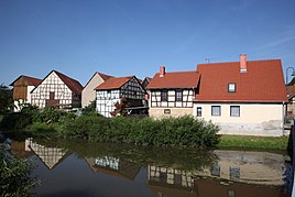
Gleusdorf
|
Gleusdorf
Community Untermerzbach
Coordinates: 50 ° 4 ′ 58 ″ N , 10 ° 51 ′ 30 ″ E
|
|
|---|---|
| Height : | 251 (250-300) m |
| Residents : | 200 (2012) |
| Incorporation : | May 1, 1978 |
| Postal code : | 96190 |
| Area code : | 09533 |
Gleusdorf is a district of the municipality of Untermerzbach in the Lower Franconian district of Haßberge .
geography
Gleusdorf is located on the Itz , about 20 kilometers north of Bamberg , 10 kilometers west of Bad Staffelstein and 6 kilometers southeast of Ebern .
history
1126 Gleusdorf was first mentioned indirectly with the witness "Gotefridus de clupestorf" in a document from the Banz monastery .
Attractions
- The oldest part of the Catholic branch church of the Birth of Mary, the saddle roof of the nave, is dated to 1484/85. The retracted choir of the hall building bears the designation "1663", the roof construction dates from 1736/1737. The modified tower roof of the ridge with onion hood and lantern is dated to 1737. The sacristy annex has a pyramid roof. The core of the churchyard wall made of sandstone blocks goes back to the 17th and 18th centuries. Century back. A parament house , a single-storey saddle roof building with clapboard cladding, was built around 1900 next to the church.
- Gleusdorf Castle
- synagogue
Web links
Commons : Gleusdorf - Collection of images, videos and audio files
Individual evidence
- ^ Werner Schmiedel: Districts Ebern and Hofheim . Historical book of place names of Bavaria. Lower Franconia. Volume 2: Districts of Ebern and Hofheim. Commission for Bavarian History, Munich 1973, ISBN 3 7696 9872 X . P. 15.


