
Heiligenstadt in Upper Franconia
| coat of arms | Germany map | |
|---|---|---|
.svg)
|
Coordinates: 49 ° 52 ' N , 11 ° 10' E |
|
| Basic data | ||
| State : | Bavaria | |
| Administrative region : | Upper Franconia | |
| County : | Bamberg | |
| Height : | 304 m above sea level NHN | |
| Area : | 76.71 km 2 | |
| Residents: | 3473 (Dec. 31, 2019) | |
| Population density : | 45 inhabitants per km 2 | |
| Postal code : | 91332 | |
| Area code : | 09198 | |
| License plate : | BA | |
| Community key : | 09 4 71 142 | |
| Market structure: | 25 districts | |
Market administration address : |
Marktplatz 20 91332 Heiligenstadt i.OFr. |
|
| Website : | ||
| Mayor : | Stefan Reichold ( SPD ) | |
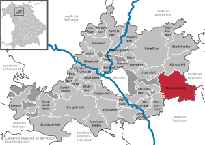
| Location of the market in Heiligenstadt i.OFr. in the Bamberg district | ||
  |
||

Heiligenstadt in Upper Franconia (officially: Heiligenstadt i.OFr. ) Is a market in the Upper Franconian district of Bamberg and is located in Franconian Switzerland .
geography
Geographical location
The municipality is located in the Leinleitertal in the Franconian Switzerland-Veldenstein Forest Nature Park in the southeastern district of Bamberg.
The 25 parts of the municipality lie along the valley of the Leinleiter and on the adjacent Jura plateau. Veilbronn is 329 meters above sea level. The highest point is the Altenberg behind Zoggendorf at 583 meters above sea level.
The villages on the heights from Volkmannsreuth to Teuchatz are part of the Long Mile . The North Jura joins the Seigelstein near Lindach .
The mountain villages east of the Leinleiter are part of the Aufseßer Mountains .
Neighboring communities
Neighboring municipalities are (starting from the north and clockwise):

|

|

|

|

|

|

|

|
| Koenigsfeld | Aufseß | Wiesenttal | Lower leash | Eggolsheim | Buttenheim | Strullendorf | Litzendorf |
| Bamberg district | Bayreuth district | Forchheim district | Forchheim district | Forchheim district | Bamberg district | Bamberg district | Bamberg district |
Community structure
There are 25 districts:
With a surface area of 77 square kilometers, the municipality is the third largest municipality in the Bamberg district, but it is also one of the sparsely populated areas.

|

|
Brunn lies on a plateau between Hohenpölz and Greifenstein Castle . |

|
130 inhabitants |

|

|
Burggrub is located on the back of the Altenberg and below the 525 meter high Eichenberg in the valley of the Leinleiter, 378 meters above sea level. NN. |

|
167 inhabitants |
| Geisberg | ||||

|
|
The hamlet of Geisdorf is about 500 meters above sea level. NN. on a terrace of the Jura. |

|
27 inhabitants |

|

|
Greifenstein is 502 meters above sea level. NN and is the ancestral castle of the Stauffenberg family . |
|
11 inhabitants |

|

|
Heiligenstadt is the center of the market and most of the population lives here. |

|
1,333 inhabitants |

|

|
The Heroldsmühle is located near the source of the Leinleiter spring . |

|
9 inhabitants |

|

|
Herzogenreuth is 566 meters above sea level. NN. and is thus the highest village in the Bamberg district. |

|
139 inhabitants |

|

|
Hohenpölz with the 30 meter high bell tower of the church can be seen from almost everywhere on the heights of the Franconian Jura . |

|
141 inhabitants |

|

|
Kalteneggolsfeld is 520 meters above sea level, on the edge of the Long Mile. |

|
141 inhabitants |

|
.jpg)
|
Leidingshof is located in the southeastern corner of the Bamberg district. |

|
33 inhabitants |

|

|
Lindach was the smallest municipality in Bavaria until the regional reform. |

|
69 inhabitants |

|

|
Not far from Neudorf begins the Werntal, which leads to Veilbronn. |

|
49 inhabitants |

|

|
The Neumühle is located on the Volletsbach at a height of 370 m below Greifenstein Castle and is included in most of the images of the castle. |

|
24 inhabitants |

|

|
Oberleinleiter is 386 meters above sea level. The landmark of the village is the 520 meter high Kreuzstein rock, from which one has a panorama over the corridor to the villages of the Bamberg Jura. |

|
177 inhabitants |

|

|
Oberngrub is located on the plateau and is part of the Long Mile . |

|
172 inhabitants |

|

|
Reckendorf is located in a side valley of the Leinleiter, two kilometers north of Heiligenstadt. |

|
90 inhabitants |

|

|
Siegritz is located near the Werntal on the Alb plateau at an altitude of about 456 meters in the extreme southeast of the Bamberg district. |

|
190 inhabitants |

|

|
Stücht formerly belonged to the Lords of Stauffenberg at Greifenstein Castle. |

|
76 inhabitants |

|

|
Teuchatz lies in a small depression (545 meters above sea level) on the edge of the western ridge of the Franconian Alb. |

|
213 inhabitants |

|

|
The parish church of St. Martin in Tiefenpölz protrudes prominently over the village. |

|
138 inhabitants |

|

|
Traindorf is less than a kilometer south of Heiligenstadt in the valley of the Leinleiter. |

|
155 inhabitants |

|

|
Veilbronn is located south of Heiligenstadt in the Leinleitertal and is known as a holiday resort. |

|
72 inhabitants |

|

|
Volkmannsreuth lies on the plateau of the Franconian Jura. |

|
54 inhabitants |

|

|
Zoggendorf is dominated by the 585 meter high Altenberg. |

|
105 inhabitants |
- Population as of January 1, 2005
history
Until the church is planted
Prehistoric finds show that the area of the market was inhabited, at least temporarily, thousands of years ago. But it was not until the time of the Great Migration , around the year 500, that the first permanent settlements emerged. However, it was not mentioned in a document until much later.
The villages of the municipality emerged about 1000 years ago. Heiligenstadt itself existed before the foundation of the Bamberg diocese (1007 AD).
In the Leinleitertal there were manors of the knights of Streitberg . In 1525 insurgent farmers caused severe damage to the castles. In 1541, Heiligenstadt was granted market privilege by the emperor .
In 1580 the Reformation was introduced in Heiligenstadt and Unterleinleiter . In 1690, the Bamberg prince-bishop Marquard Sebastian Schenk von Stauffenberg acquired the manors Greifenstein and Burggrub including patronage over Heiligenstadt. The Graf en Schenk von Stauffenberg still live in Greifenstein Castle and the Burggrub Castle Estate. The localities in the northern part of the municipality come from the former Bamberg offices. There was no religious change here. Since the Reichsdeputationshauptschluss of 1803, the place, like large parts of Franconia, has belonged to Bavaria (see also History of Franconia ).
Incorporations
As part of the regional reform in Bavaria , the communities of Brunn, Burggrub, Hohenpölz, Oberleinleiter, Siegritz, Stücht, Traindorf and Zoggendorf joined the market in Heiligenstadt in Upper Franconia on January 1, 1971. Part of the Dürrbrunn community was added on April 1, 1971. Herzogenreuth, Kalteneggolsfeld, Lindach, Oberngrub, Teuchatz and Tiefenpölz followed on May 1, 1978.
Population development
In the period from 1988 to 2018, the market grew from 3,494 to 3,518 by 24 inhabitants or 0.7%. A peak was reached on December 31, 1998 with 3753 inhabitants.
Wars
Hussite Storm (1430)
The first major war that is known in detail was the Hussite War in 1430. The Heiligenstadt parish description reports that in 1429 individual Bohemian heaps destroyed parts of Heiligenstadt, the whole of Burggrub and Zoggendorf . Margrave Friedrich, who was called by Bamberg for help , succeeded in persuading the Hussite leader Prokop to turn back by paying an immense sum of money . The subjects had to raise the money through special taxes.
Peasants Revolt (1525)
During the peasant uprising of 1525, peasants from the Bamberger Grund plundered and burned the Burggrub castle , and an Ebermannstadt heap looted the castle in Veilbronn . When the peasant uprising was put down by the Swabian Federation , five of their leaders were beheaded in the market in Hollfeld .
Markgräflerkrieg (1552–1554)
The Margravial War was initiated in 1552 by Margrave Albrecht Alcibiades of Brandenburg - Kulmbach . In April 1553, margrave riders ravaged the village of Herzogenreuth . Hohenpölz was to receive a protection letter by paying protection money in order to avoid the worst.
Thirty Years War (1618-1648)
The Thirty Years War caused the greatest damage of all wars. On September 10, 1632, the Pastor from Mistendorf reported the sacking of the villages of Teuchatz and Tiefenpölz, which he looked after . The perpetrators were not the Swedes , but the Imperialists fighting for the Catholic side. The Kastner of the Streitburg wrote in 1633 to the margrave in Kulmbach that “the subjects had all their cattle and grain taken away and many were brutally murdered”. In some villages over half of the subjects died miserably. There was "departure" of desolate goods in Volkmannsreuth , Brunn , Oberleinleiter , Burggrub and Stücht . Times had become so uncertain that hardly any records were kept. You no longer knew who was fighting for or against whom. On June 12, 1634 Weimar riders plundered the villages and stole the cattle from the farmers. An eyewitness wrote:
"On the same day we saw villages burning in three places on the mountains near Hollfeld, the flames reached the clouds."
In this context, Heiligenstadt was also likely to have been visited.
Seven Years War 1756–1763
The Seven Years' War between Prussia and Austria was about supremacy in Central Europe. The Prussians moved north via Fürth and set up their quarters in Ebermannstadt in the summer of 1757 . They sacked the city before pulling up the rope ladder. On the way they extorted everything that was available: money, cattle and food. Veilbronn and Traindorf suffered from the passing soldiers . Barely a year later, the next Prussian invasion followed and another year later the third. In November 1762 Prussian troops lay again in the area around Heiligenstadt for three weeks.
Napoleonic Wars (1796)
During the Napoleonic Wars , an army corps under General Jean-Baptiste Jourdan flooded Franconian Switzerland while retreating. French military police rode through the villages and extorted protection money from the farmers - sometimes several times in a row.
Franco-German War (1870)
With the annexation of Alsace-Lorraine , many conscripts were stationed in the Metz garrison , some of whom stayed there forever and married, such as Jean Puff from the Heroldsmühle .
First World War
Although the First World War took place far from home, the losses in people were similar to those in the Thirty Years War.
Second World War
At the end of the Second World War , the villagers hid with their cattle, while the village elders walked towards the US soldiers with a white flag to hand over their village. The Americans set up a military government and ordered the surrender of all firearms on the death penalty . A blasting area was set up near Teuchatz, where the Wehrmacht ammunition was destroyed.
chronology
- 1541: market privilege
- 1580: Reformation in Heiligenstadt and Unterleinleiter
- 1803: Heiligenstadt falls to Bavaria
- 1915: Railway connection via Ebermannstadt to Forchheim
- 1968: closure of the railway line
- 1971: First municipal area reform
- 1978: Second municipal reform
Place name

The place name Heiligenstadt has nothing to do with the word holy . Rather, it is an example of how names can change over time. The place was first mentioned in 1365 as Haldenstat (= town on the Halde, on the slope).
In a report from the time of the discovery of Franconian Switzerland , Dr. Gottlieb Zimmermann set up a hiking route along the Leinleiter in 1840 , with the mention of the old name of Heiligenstadt showing that the place name has nothing to do with saints, but with the word Halde :
"Heiligenstadt, also called the Lutheran Hallstadt, is a pretty market town in the valley, where travelers can find several and pretty good inns."
Luther 's Hallstadt was called the place to differentiate it from the mostly Catholic Hallstadt near Bamberg.
religion
The most Catholic and Protestant villages in the area of the Archdiocese of Bamberg are in the area of Markt Heiligenstadt : In Leidingshof there is not a single Catholic, in the villages of the parish Tiefenpölz almost no one is Protestant. Mainly Lutherans live in the market center, while the majority are Catholics in the new building areas . Protestant Christians are in the majority in the villages around Heiligenstadt. According to the census on May 9, 2011, 47.3% of the population are Roman Catholic and 41.3% Evangelical Lutheran. 11.4% of the population belong to another religion or are non-denominational.
Churches
Roman Catholic Church
Heiligenstadt-Burggrub is the patronage parish with the right to present the taverns of Stauffenberg, Greifenstein, and is called St. Paul, Heiligenstadt-Burggrub.
Evangelical Lutheran Church
The Evangelical Lutheran Church Community has its center in the St. Vitus and St. Michaels Church . The Johanneskirche is a branch church in the Siegritz district .
Free Churches
The Baptist congregation of Heiligenstadt, which belongs to the Federation of Evangelical Free Churches , was founded in 1978. Your church is the Christ Church, consecrated in 2003 . It is located on the grounds of the Evangelical-Free Church Diakoniewerk Tabea Leinleitertal . In addition to facilities for care for the elderly, the plant also includes a senior citizens' residence, holiday apartments and a conference and leisure center.
Jews
As early as 1430 there were Jews in the surrounding towns who traded with farmers in Heiligenstadt. In Heiligenstadt itself there were probably no Jews at that time.
According to the fiefdom documents, at least three Jewish families lived in Heiligenstadt in 1605. In 1617 there are already seven families. According to a register from Pastor Knab from Heiligenstadt in 1758, a total of 1627 souls lived in his parish, of which 239 were Catholics and 58 Jews. In 1692 a slaughter and battle order was issued. In 1734 Jews were allowed to take their books publicly into their synagogue accompanied by musicians .
A Jewish prayer room had existed in a private house since 1670. A synagogue planned around 1818 was not built. The Jewish community developed to its greatest boom in the period from 1750 to 1850, with a good 20% of the Heiligenstadt population (426 inhabitants in total) being Jews in 1852. In the following years, many families emigrated to the surrounding area or to America. At the end of the 19th century the congregation had shrunk to twelve members. In 1902 it had to merge with the municipality in Aufseß by an official decision .
The last relic from the time of the Jewish community is the Jewish cemetery on Mount Kuhlich.
politics
Mayoral elections
The first mayor since May 1, 2020 is Stefan Reichold (SPD), who prevailed over three opposing candidates with 68.20% of the vote. His predecessor since 1990 was Helmut Krämer ( unity ), who was re-elected in 2008 with 55.88% and in 2014 with 59.41% of the votes. From 1960 to 1990 Johann Daum (SPD) acted as head of the community.
Municipal council elections
The elections to the municipal council on March 15, 2020 in Heiligenstadt led to the following result (with the distribution of seats from previous elections) with a turnout of 77.29%:
| Party / group of voters | Seats 2002 | Seats 2008 | Seats 2014 | Share of votes 2020 | Seats 2020 | |
| CSU | 7th | 6th | 5 | 30.16% | 5 | |
| SPD - ÜWG * | 4th | 3 | 4th | 38.24% | 6th | |
| Proximity to citizens (BN) | - | 3 | 5 | 23.95% | 4th | |
| Voting Community Future (WZK) | - | - | - | 7.65% | 1 | |
| Community of voters (WG) | 3 | 2 | 2 | - | - | |
| Future Jura (ZJ) | 2 | 2 | - | - | - | |
| total | 16 | 16 | 16 | 100% | 16 |
|---|
* ÜWG = non-partisan community of voters
coat of arms
|
|
Blazon : " Archangel Michael standing in silver on silver cloudswith golden wings, red cloak and blue undergarment, a golden helmet with red plume on his head, in his right hand a green olive branch."
As part of the regional reform, the municipalities of Brunn, Burggrub, Hohenpölz, Oberleinleiter, Siegritz, Stücht, Traindorf, Zoggendorf and Markt Heiligenstadt merged in 1971. The new municipality took over the coat of arms of the market in Heiligenstadt, which was called the "coat of arms that had been used for a long time " during the revision of the coat of arms in 1819 . Older seals have not survived, however. |
| Justification of the coat of arms: The Archangel Michael is next to the Saint Veit patron saint of the now Protestant St. Vitus and St. Michaels Church in Heiligenstadt. |
Architectural monuments
Personalities
Born in Heiligenstadt
- Albert Weber (1828–1879), piano maker
People who worked in Heiligenstadt
- Karl Brdlik (1874–1948), teacher and local history researcher
- Helmut Grundmann (1920–2009), Baptist pastor , general secretary of the European Baptist Mission Society (1967–1984) and pastor of the Heiligenstadt Family Center (1984–1989)
Economy and Infrastructure
economy
The industrialization that began in the surrounding towns contributed to the emigration of small craftsmen and young people. Even the displaced persons after the Second World War did not change this rural exodus decisively. Not all of them stayed forever. An upswing did not begin until the 1970s, when Mayor Daum did everything in his power to make Heiligenstadt more attractive for employees. For this purpose jobs and shopping opportunities have been created. In addition, there were state subsidies that enabled the town center to be redeveloped.
Voluntary fire brigades
There are voluntary fire departments in Brunn, Burggrub, Heiligenstadt, Herzogenreuth, Hohenpölz, Kalteneggolsfeld, Lindach, Oberleinleiter, Oberngrub, Siegritz, Stücht / Reckendorf, Teuchatz, Tiefenpölz, Traindorf, Volkmannsreuth and Zoggendorf.
Breweries
There are still two breweries in the market area: the Aichinger brewery in Heiligenstadt and the Ott brewery in Oberleinleiter.
tourism
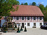
To promote tourism, the old school was converted into today's town hall and the historic market square was redesigned. In addition, the old Örtel barn was converted into the house of the citizens.
The market with its listed houses and its historically interesting church is a well-known destination.
Especially during Easter it is visited by many tourists who visit the Easter fountains in Franconian Switzerland .
The Protestant St. Vitus and St. Michaels Church goes back to an earlier tithe barn. The free-standing bell tower stands on the remains of an earlier castle. The rich baroque painting of the wooden loft and the field ceiling is unusual for a Protestant church .
Picture gallery

- Heiligenstadt and the surrounding area

Heiligenstadt from the pavilion

pavilion

Churches and Greifenstein

from the Seigelstein

View from Altenberg

at the line ladder
Town hall and Easter fountain

Ammonite collection

at the line ladder

renatured line ladder


Transport links
railroad

From 1915 to 1968, Heiligenstadt was the terminus of the Heiligenstadt – Ebermannstadt branch line and on to Forchheim. Before the construction of this route came about, the people of Heiligenstadt still had to do a lot of persuasion. The arguments cited were the basalt deposits near Oberleinleiter, iron ore finds near Königsfeld , the wood of the Stauffenberg and Aufsessian forests, the handling of grain and cattle, and the emerging tourism in Franconian Switzerland .
For the neighbors, the construction of the railway meant a financial burden, because the railway demanded the assignment of the required areas and related construction measures such as access roads. But even more distant communities were ready to do their part, because they also hoped that there would be an extension to Hollfeld or Scheßlitz later . However, the Gasseldorfer caused difficulties. They did not want to give up their property, so coercion had to be carried out.
Construction work began in June 1913. 117,000 cubic meters of earth had to be moved, eleven bridges to be built, and the bed of the linen ladder had to be moved in five places. Over 100 workers and many local residents found work.
In 1915 the project was ready for use. On October 4, 1915, the Ebermannstadt-Heiligenstadt local railway went into operation. The teacher Hans Spörl writes:
“A Heiligenstadt train driver, Fritz Krasser, a son of the former mayor Friedrich Krasser in Heiligenstadt, who was already working on building the railway at the time, asked to be allowed to take the first train to his home town. The wish was granted to him. "
It also says:
“Mayor Richter welcomed the guests who had arrived, gave them a warm welcome and thanked everyone who had helped with this important work for the community of Heiligenstadt. In his further remarks, he showed the development of railway construction from its beginnings to the current opening.
With thanks to God, he combined the wish that the new railway to Heiligenstadt should continue to be in God's hands and become a blessing for the community of Heiligenstadt the guests and patrons at the Gasthof Hösch together for a meal, where the importance of this festive day was remembered in various speeches and an enthusiastic 'Glück Auf!' for Heiligenstadt and its surroundings was expressed. Heiligenstadt is proud of its railway! "
The pride did not last long, as passenger traffic was stopped as early as June 1960 and freight traffic was discontinued in 1968.
Streets
As early as 1912 it was signaled that an automobile post was planned from Bamberg to Heiligenstadt. In 1930 the post bus ran as required . It was probably mainly a trip to Franconian Switzerland . The Post justified its lack of commitment primarily with the poor road conditions. The Kraftpost line to Hollfeld was discontinued in autumn 1931 because the neighboring communities of Zoggendorf and Stücht did not participate to the required extent. Now the postillon drove again in his horse-drawn carriage.
Roads suitable for cars have only existed in the area of the market since they were expanded by the Reich Labor Service in the 1930s. These construction measures were mainly job creation measures. In this context, the roads from Veilbronn to Siegritz and from Hohenpölz to Reckendorf were built.
The biggest project of the post-war period was the construction of the Veilbronn Viaduct in the 1950s.
post Office
The oldest note about the postal system in Heiligenstadt comes from the year 1733 when the future Catholic priest Josef Rösch in Bamberg stated that his father had been a postal administrator in Heiligenstadt for many years. In 1853 the letter defeat was replaced by a letter and driving post expedition. If the postman changed, so too changed the place for the postal expedition. In 1892, Heiligenstadt received a post stable for a so-called Cariol post line to Aufseß and Hollfeld . Such a horse mail line also ran to the train station in Ebermannstadt . In 1898 a regular postal agency was established, whose post office owners complained about the strenuous service because the postal vehicles always passed through the town at night or in the early morning hours and they always had to be there.
The letters and parcels were transported by vehicles. Until the 1960s, mail delivery services were provided by postmen on foot or by bicycle.
On October 1st, 1874, Heiligenstadt received a telegraph station with Morse code , which was used until 1926. In 1907 a telephone exchange was set up. The first telephone connections received the Gasthof Hösch in Heiligenstadt and Schloss Greifenstein as well as the communities Burggrub and Hohenpölz .
literature
- Johann Kaspar Bundschuh : Heiligenstadt . In: Geographical Statistical-Topographical Lexicon of Franconia . tape 2 : El-H . Verlag der Stettinische Buchhandlung, Ulm 1800, DNB 790364298 , OCLC 833753081 , Sp. 550 ( digitized version ).
- Johann Kaspar Bundschuh : Lutheran Holy City . In: Geographical Statistical-Topographical Lexicon of Franconia . tape 3 : I-Ne . Verlag der Stettinische Buchhandlung, Ulm 1801, DNB 790364301 , OCLC 833753092 , Sp. 405 ( digitized version ).
- Klaus Guth (ed.): Jewish rural communities in Upper Franconia (1800–1942). A historical-topographical handbook. Bamberg 1988, ISBN 3-87052-392-1 . on Heiligenstadt pp. 186–194.
- Urban planning redevelopment in Heiligenstadt (Score) by Philipp Hümmer and Peter Locher Front (Town construction reorganization in Heiligenstadt).
- Pleikard Joseph Stumpf : Heiligenstadt . In: Bavaria: a geographical-statistical-historical handbook of the kingdom; for the Bavarian people . Second part. Munich 1853, p. 580-581 ( digitized version ).
- Dieter Zöberlein: Community chronicle Markt Heiligenstadt i. OFr. Published on the occasion of the celebration of the 450th anniversary of the granting of market rights to Heiligenstadt i. OFr. - Heiligenstadt 1995.
- Dieter Zöberlein: From the history of the parish of Heiligenstadt. published in the Archive for History of Upper Franconia , Volume 93, pp. 9–78, Bayreuth 2013, ISSN 0066-6335
- Dieter Zöberlein: The von Streitberg, story of a Franconian noble family. 3 parts, self-published without ISBN, Burggrub 2018, here especially part 2, pp. 235–251; Part 3, pp. 57–76, 104–110, 116–119 (contains extensive articles on Heiligenstadt from the time before 1694).
Web links
- Heiligenstadt market
- Heiligenstadt in Upper Franconia: Official statistics of the LfStat
- The von Streitberg as the owner of Heiligenstadt
Individual evidence
- ↑ "Data 2" sheet, Statistical Report A1200C 202041 Population of the municipalities, districts and administrative districts 1st quarter 2020 (population based on the 2011 census) ( help ).
- ^ Bavarian State Library, location search
- ↑ Johannes Neumann: The Reichsdeputationshauptschluss of 1803: Requirements and consequences (PDF file; 179 kB)
- ^ Wilhelm Volkert (ed.): Handbook of Bavarian offices, communities and courts 1799–1980 . CH Beck, Munich 1983, ISBN 3-406-09669-7 , p. 451 .
- ^ Federal Statistical Office (ed.): Historical municipality directory for the Federal Republic of Germany. Name, border and key number changes in municipalities, counties and administrative districts from May 27, 1970 to December 31, 1982 . W. Kohlhammer GmbH, Stuttgart / Mainz 1983, ISBN 3-17-003263-1 , p. 672 .
- ↑ a b c Dieter Zöberlein: Community chronicle market Heiligenstadt i. OFr.
- ^ Tabea Leinleitnertal: start page ; Accessed June 13, 2015
- ↑ On the history of the Jewish community in Heiligenstadt
- ↑ Mayor. Heiligenstadt community in Upper Franconia, accessed on August 15, 2020 .
- ↑ Markt Heiligenstadt i. OFr., Result of local elections 2020
- ^ Entry on the coat of arms of Heiligenstadt in Upper Franconia in the database of the House of Bavarian History
- ↑ PDF at www.herischek-vornlocher.de
Brunn | Burggrub | Geisdorf | Greifenstein | Heroldsmühle | Herzogenreuth | Hohenpölz | Kalteneggolsfeld | Leidingshof | Lindach | Neudorf | Neumühle | Oberleinleiter | Oberngrub | Reckendorf | Siegritz | Stücht | Teuchatz | Tiefenpölz | Traindorf | Veilbronn | Volkmannsreuth | Zoggendorf

Altendorf | Baunach | Bischberg | Breitengüßbach | Burgebrach | Burgwindheim | Buttenheim | Ebrach | Frensdorf | Gerach | Gundelsheim | Hallstadt | Heiligenstadt in Upper Franconia | Hirschaid | Kemmern | Koenigsfeld | Louder | Lisberg | Litzendorf | Memmelsdorf | Oberhaid | Pettstadt | Pommersfelden | Priesendorf | Rattelsdorf | Reckendorf | Scheßlitz | Key field | Schönbrunn im Steigerwald | Stadelhofen | Stegaurach | Strullendorf | Viereth-Trunstadt | Walsdorf | Wattendorf | Zapfendorf
Community-free areas
Ebracher Forst |
Eichwald |
Geisberger Forest |
Main Bog Forest |
Koppenwinder Forest |
Lindach |
Semberg |
Steinachsrangen |
Winkelhofer Forest |
Zückshuter Forest