Long mile
| Long mile / On the long mile | ||
|---|---|---|
|
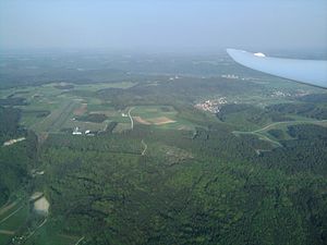
Aerial view of the Long Mile with Flintstone Castle from the west |
||
| height | 517 m above sea level NHN | |
| location | Forchheim district , Upper Franconia , Bavaria , Germany | |
| Mountains | Franconian Alb | |
| Coordinates | 49 ° 47 '53 " N , 11 ° 7' 57" E | |
|
|
||
| Type | plateau | |
|
Aerial view Long Mile from the southwest |
||
The long mile is a maximum of about 517 m above sea level. NHN high plateau (hence the name Auf der Langen Meile is often used) in Franconian Switzerland in the Upper Franconian district of Forchheim ( Bavaria ).
Geographical location
The Long Mile is located on the western roof of the Franconian Alb in the Franconian Switzerland-Veldenstein Forest Nature Park . Your plateau lies in the municipality of Heiligenstadt ( Bamberg district ) in the north-northeast, Ebermannstadt in the east, Forchheim in the south-southeast and Eggolsheim in the west. It is surrounded by Eschlipp in the north-north-east, Niedermirsberg , Breitenbach , Neuses-Poxstall , Reifenberg and Weilersbach in the east, Ehrlersheim and Rescuers in the south, Kauernhofen , Weigelshofen , Drosendorf , Götzendorf and Tiefenstürmig in the west and Drgendorf in the north-north-west.
In the northern transition area of the Long Mile to the actual plateau of the Franconian Alb there are limestone quarries between Eschlipp and Drgendorf. There the state road 2260 leads from Ebermannstadt past Eschlipp between the quarries to Drgendorf. To the east the plateau falls into the valley of the Wiesent , a Regnitz tributary, and to the west into that of the Eggerbach, a short tributary of the Regnitz and the Main-Danube Canal .
Surveys
The elevations of the Long Mile, which only represent gentle hills or only prominent parts of the high plateau, include - with heights in meters (m) above sea level (NHN):
- Schützenberg (517 m), northeast of Rescuers
- Wachknock (517 m), between Niedermirsberg and Breitenbach
- Mirsberger Höhe (514.5 m), northwest of Niedermirsberg
- Rotenberg (510 m), east-northeast of Kauernhofen
- Savior pulpit (506.3 m), east of Rescuers
- Steinberg (506 m), north of Reifenberg
- Högelstein (497.9 m), between Kauernhofen and Saviors
- Schloßberg (493.1 m), northeast of Drosendorf
geology
The rocks of the Long Mile come from the Jura Sea and consist of clay , sandstone and limestone . Stratified rock from Malm characterizes the plateau. The spring water is used to supply drinking water to some of the surrounding villages. It has a high lime content.
Protected areas
One of the western areas of the multi-part fauna-flora-habitat area Wiesent-Tal with side valleys extends on the eastern flank of the Long Mile (FFH No. 6233-371). The western flank of the table-like mountain belongs to the southern area of the multi-part FFH area Albtrauf from the Friesener Warte to the Long Mile (FFH no. 6132-371). Large parts of the Long Mile are in the western part of the 2001 founded and 1,021.64 square kilometers of protected landscape Franconian Switzerland Veldenstein Forest (LSG no. 322697).
Landscape and sights
The long mile is forested on its steeply sloping slopes, the high plateau is unforested in many places and is used for agriculture.
On the Long Mile, south of the Mirsberger Höhe, there is the Feuerstein Castle airfield and the Feuerstein observatory south of it . At the Wachknock, east of it, is the Feuerstein Castle Youth Center .
Web links
Individual evidence
- ↑ a b c map services ( memento of the original dated December 19, 2012 in the Internet Archive ) Info: The archive link was inserted automatically and has not yet been checked. Please check the original and archive link according to the instructions and then remove this notice. of the BfN


