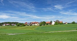
Tiefenlesau
|
Tiefenlesau
City of Hollfeld
Coordinates: 49 ° 54 ′ 4 " N , 11 ° 16 ′ 4" E
|
|
|---|---|
| Height : | 420 m above sea level NHN |
| Residents : | 90 (1987) |
| Postal code : | 96142 |
| Area code : | 09204 |
|
The Hollfeld district of Tiefenlesau
|
|
The village of Tiefenlesau is part of the town of Hollfeld in Upper Franconia .
geography
The village is located about four and a half kilometers south-southwest of Hollfeld at an altitude of 420 m above sea level. NHN .
history
Due to the administrative reforms in the Kingdom of Bavaria at the beginning of the 19th century , the place became part of the rural community of Hochstahl , to which the villages of Dörnhof , Kobelsberg and Zochenreuth also belonged. When the municipality of Hochstahl was integrated into the municipality of Aufseß in the course of the municipal regional reform in Bavaria in the 1970s , Tiefenlesau was incorporated into the city of Hollfeld as the only district. In 1987 Tiefenlesau had 90 inhabitants.
traffic
A municipal road, the southern end of which joins the state road 2188 in the neighboring town of Hochstahl, two kilometers away , connects to the public road network. In a north-easterly direction, this municipal road leads to State Road 2191 and ends there at Treppendorf and south-east in Welkendorf or Stechendorf .
Trivia
In 2015, Tiefenlesau was the venue for the Bayern 3 village festival .
Web links
- Location of Tiefenlesau in the BayernAtlas (accessed on March 4, 2017)
- Tiefenlesau on a historical map (BayernAtlas Klassik) (accessed on March 4, 2017)
Individual evidence
- ↑ Population of Tiefenlesau (1987)
- ^ Tiefenlesau in the local database of the Bayerische Landesbibliothek Online
- ↑ Historical municipality register for the Federal Republic of Germany (1970–1982), page 676
- ↑ That was the Bayern3 village festival in Tiefenlesau (North Bavarian Courier)

