Truppach (Wiesent)
| Truppach Wiesent | ||
|
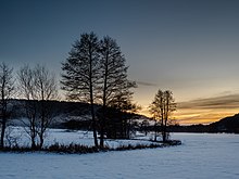
Truppachtal in winter |
||
| Data | ||
| Water code | DE : 24262 | |
| location |
Franconian Switzerland
|
|
| River system | Rhine | |
| Drain over | Wiesent → Regnitz → Main → Rhine → North Sea | |
| confluence | of Eschenbach and Weides in Mistelgau -Obernsees 49 ° 54 '54 " N , 11 ° 23' 55" O |
|
| Source height | 384 m above sea level NN | |
| muzzle | at Plankenfels -Kaupersberg in the Wiesent Coordinates: 49 ° 52 '39 " N , 11 ° 20' 5" E 49 ° 52 '39 " N , 11 ° 20' 5" E |
|
| Mouth height | 358 m above sea level NN | |
| Height difference | 26 m | |
| Bottom slope | 3.9 ‰ | |
| length | 6.7 km | |
| Catchment area | 106 km² | |
| Discharge at the Plankenfels A Eo gauge: 105.58 km² |
NNQ MNQ MQ Mq MHQ HHQ (1992) |
72 l / s 198 l / s 981 l / s 9.3 l / (s km²) 16.1 m³ / s 25.9 m³ / s |
The Truppach is a left and northeastern tributary of the Wiesent in the Bavarian Upper Franconia in Germany .
geography
course
The Truppach arises from the confluence of the Eschenbach and Weides in Obernsees . It flows into the Wiesent near Kaupersberg .
Tributaries
- Erlichbach (right)
- Leimbach (left)
- Obmannsgraben (left)
- Lochau (right)
places
The Truppach flows through the following places:
- Mistelgau- Obernsee
- Mistelgau-Truppach
- Plankenfels -Ringau
- Plankenfels-Altneuwirtshaus
- Plankenfels-Kaupersberg
literature
- Johann Kaspar Bundschuh : Truppach . In: Geographical Statistical-Topographical Lexicon of Franconia . tape 5 : S-U . Verlag der Stettinische Buchhandlung, Ulm 1802, DNB 790364328 , OCLC 833753112 , Sp. 592-593 ( digitized version ).
See also
Individual evidence
- ↑ Map services of the Bavarian State Office for the Environment
- ↑ Flood Action Plan Main
- ↑ Bavarian flood news service (as of September 7, 2011)

