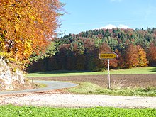
Steigenhof
|
Steigenhof
Steigenbauer City of Velden
Coordinates: 49 ° 37 '35 " N , 11 ° 25' 54" E
|
|
|---|---|
| Height : | 524 m above sea level NN |
| Postal code : | 91235 |
|
The wasteland of Steigenhof
|
|
The solitude of Steigenhof , known as Steigenbauer in BayernAtlas , belongs to the town of Velden in Middle Franconia and is located at an altitude of around 524 m . The locality does not form a separate district of the city, but is assigned to the neighboring hamlet of Henneberg , from which it is just under a kilometer away in a west-northwest direction. Together with Henneberg, Steigenhof was transferred from the dissolved municipality of Treuf to Velden in 1972 .
Steigenhof is only connected to the public road network via two unpaved field paths. The southern of these two paths begins in the center of Henneberg, the northern has its starting point on the connecting road from Riegelstein to Eichenstruth .
Web links
- Location of Steigenhof in the BayernAtlas (accessed on January 29, 2017)
Individual evidence
- ↑ Henneberg and Steigenhof on the website of the city of Velden (accessed on January 29, 2017)

