
Rumpelbach Gorge
| Rumpelbach Gorge | ||
|---|---|---|
 Rumpelbach Gorge |
||
| location | District of Nürnberger Land , Bavaria | |
| Waters | Roethenbach | |
| Mountains | Franconian Alb | |
| Geographical location | 49 ° 24 '18 " N , 11 ° 19' 59" E | |
|
||
| Type | canyon | |
| rock | Rhätsandstein | |
| height | 395 m | |
| particularities | Natural monument , geotope | |

The Rumpelbach Gorge is a small sandstone gorge in Middle Franconia ( Bavaria ) near the Altdorf district of Röthenbach . After in the city Röthenbach in the Pegnitz opens Röthenbach , the rocky notch located at the upper reaches, it will also Röthenbachklamm called.
Geographical location
The gorge is located in the municipality-free Winkelhaid area about 400 meters northwest of Röthenbach and 2.6 kilometers east of Ungelstetten .
description
In the small but wildly romantic gorge, the Röthenbach flows over a length of around 300 meters, partly between heavily weathered sandstone rock formations up to five meters high . At the entrance to the gorge close to Röthenbach, the stream has created a small waterfall ; the river drops down three meters over two small steps. In the adjoining rock formations, there are impressive erosion , smaller caves and weathering , as well as remnants of earlier rockfalls . The sandstone banks of the upper Keuper can be seen well on the rebound slopes and further outcrops . In the wide Kerbsohlental below the gorge, the stream meanders in wide arches.

The gorge is designated by the Bavarian State Office for the Environment as geotope 574R002 and as a natural monument (ND-Nr. ND-05211). Nevertheless, garbage is dumped again and again, especially in the upper part of the gorge.
geology
Over the millennia, the brook has dug its way into the layers of the Rhät-Lias sandstone and the Upper Feuerletten, creating natural rock outcrops. About 200 million years ago, in the transition period between the Triassic (Upper Keuper = Rhät) and the Black Jura (Lias), there was a shallow inland sea in the north-west of Central Franconia in front of a mainland in the south-east. Fine-grained and sandy sediments were deposited in this shallow sea, which later solidified into clay and sandstone. Since it is not possible to clearly distinguish which of the rocks are to be assigned to the Rhaetian and which to the Lias, they are summarized as the Rhät-Lias transition layers.
There are other similar Rhätschluchten around Altdorf .
Access
The gorge is freely accessible all year round and can be easily reached on foot from Röthenbach. From there a small unmarked path leads along the stream and ends at the crossing under the A 6 motorway . The path requires good shoes and surefootedness. Most of the wooden walkways are rotten and dilapidated (as of the end of 2013). Visiting during floods is not recommended.
photos
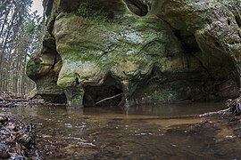
Rock with undercutting

Rock face
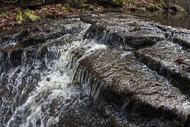
Waterfall edge

Rock fall, now overgrown

Meander with typical impact slope

The little river Röthenbach


See also
Web links
Individual evidence
- ↑ Location Rumpelbachschlucht in the BayernAtlas (accessed on January 17, 2014)
- ↑ Geotope: Rumpelbachschlucht (accessed on March 20, 2020)