Duck mountain
|
Duck mountain
Community of Leinburg
Coordinates: 49 ° 26 ′ 59 ″ N , 11 ° 22 ′ 2 ″ E
|
|
|---|---|
| Height : | 435 (425-468) m above sea level NHN |
| Residents : | 345 (2016) |
| Incorporation : | May 1, 1978 |
| Postal code : | 91227 |
| Area code : | 09120 |
|
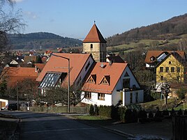
View of the village with the parish church
|
|
Entenberg is one of 17 officially named districts of the community of Leinburg in Middle Franconia .
geography
Geographical location
The parish village is located in a small valley basin, which is framed in the north by the Nonnenberg and Buchenberg and in the south by the Balcher . The Haidelbach rises south of the village on the northern slope of the Balcher in the Langes Ried forest area . The place is about four and a half kilometers east of the center of Leinburg and is at an altitude of 435 m above sea level. NHN .
Natural allocation

In terms of natural space, Entenberg belongs to the northern part of the Middle Franconian Alb and the foreland of the Northern Franconian Alb (Meynen / Schmithüsen et al.) . The steep ascent to the Albtrauf represents the boundary between the two natural space units. According to the natural spatial structure of Germany (Axel Ssymank) , they are part of the Franconian Alb main natural space unit .
geology
The parish village is located in the Hersbrucker Alb . Geologically, the Hersbrucker Alb belongs to the Franconian Jura and is part of the south-west German layer level country . In the characteristic Jura landscape of Entenberg, the underlying geological layers of the White Jura (Malm) and the Brown Jura (Dogger) emerge. From the valley perspective, these geological formations form a typical layered landscape . The Haidelbachtal has cut into the plateaus of the Alb cover and is covered with Quaternary valley fillings. The Opalinus Clay formation from the Braunjura group forms the lower layer in the settlement area of Entenberg. It consists of blue to black-gray and silty clay and clay marl stone with concretions of clay iron stone . A further layer from the Braunjura group, the so-called iron sandstone formation (Dogger Beta), is deposited thereon to the west of Entenberg . The fine to medium-grain sandstone of the geological layer contains iron debris and iron ore seams. Above that follows a Brown Jurassic layer of the Sengenthal Formation , which represents the chronostratigraphic transition between the Brown Jura and the White Jura. Calcarenite with a gray-brown to yellow-brown tint is the defining rock of this geological formation. The upper ridge of the Buchenberg and the Balcher has a layer from the Weißjura group, which can be assigned to the Hartmannshof formation (Malm Alpha and Beta) and contains marlstone with limestone layers . Layers of the dolomite- dominated Frankenalb formation are embedded in the mountain tops of the Buchberg and the Balcher .
ground

The soil type brown earth has developed on the Dogger sites . In the transition between the Brown Jura and the White Jura (Sengenthal Formation), gleye and other soils influenced by groundwater were created. Shallow Rendzina floors have established themselves on the Malm surfaces . The valleys have gleye and other groundwater-influenced soils.
climate
Entenberg is located in the cool, temperate climate zone and has a humid climate . The landscape of the village is located in the transition area between the humid Atlantic and the dry continental climate . After the climate classification of Köppen / Geiger Entenberg belongs to the temperate warm rainy climate (Cfb climate). The mean air temperature of the warmest month remains below 22 ° C and that of the coldest month above -3 ° C.
Protected area
The surrounding landscape of the village of Entenberg was placed under protection in 1985 as a landscape protection area of the Southern Jura with Moritzberg and the surrounding area (LSG-00544.01) due to its scenic beauty, the special recreational value and the efficient natural balance . The extensive 16,637 hectare protected area comprises the Jura landscapes south of the Pegnitz around the Moritzberg to Pommelsbrunn .
On the northeast slope of the Buchenberg there is the remarkable stone channel on the Buchenberg .
Cultural landscape
Entenberg is characterized by a fragmented and richly structured cultural landscape . In addition to the field terraces , historical cultural landscape elements are also former hutanger areas at the foot of the Buchenberg. Due to the widespread real division in Franconia , the municipal area was characterized by a small-scale corridor structure until the 20th century. The hallway was characterized by very narrow stripes. The strip parcels ran orthogonally to the homestead guideline and the farmsteads were largely arranged along Entenberger Hauptstrasse as the central settlement axis.
history
middle Ages
Entenberg was first mentioned in 1072, when the Eichstatt Bishop Gundekar consecrated a church there to St. Peter. This happened as part of three trips that Bishop Gundekar II of Eichstätt had undertaken in the area from 1057 to 1075 and during which he had consecrated several sacred buildings, including Entenberg. This church was a daughter church of the original parish of Offenhausen, with which Entenberg was connected by a priest path, which first led over the small saddle east of the village down to the basin of Egensbach , and from there on to Offenhausen .
At the beginning of the 12th century, the area around Entenberg was lent to Duke Konrad by Emperor Heinrich V and was then owned by the Hohenstaufen for about 100 years . Entenberg was also mentioned in a document in 1291, when it was designated as the noble seat of the knight Ulrich Schwepfermann von Entenberg.
Modern times
A profound turning point in local history took place in 1504 during the Landshut War of Succession . In that year the village, like many other places in the area, was occupied by the troops of the imperial city of Nuremberg . With the conclusion of peace a year later, it finally came into the possession of this imperial city and then belonged to its land area for almost three centuries. Together with the neighboring towns to the west, Entenberg became part of Ansbach-Bayreuth and thus Prussian in 1796 , before it became Bavarian when Nuremberg was annexed by the Kingdom of Bavaria in 1806 .
Due to the administrative reforms carried out in the Kingdom of Bavaria at the beginning of the 19th century , Entenberg became an independent rural municipality with the second municipal edict. In the course of the municipal territorial reform carried out in Bavaria in the 1970s , the Entenberg municipality was incorporated into the Leinburg municipality on May 1, 1978.
Population development in the (former) community of Entenberg
In 2018 Entenberg had 343 inhabitants.
| year | 1910 | 1933 | 1939 | 1961 | 1987 | 2016 | 2018 |
|---|---|---|---|---|---|---|---|
| population | 208 | 203 | 204 | 201 | 282 | 345 | 343 |
traffic
The connection to the public road network is established by local roads that lead to the neighboring towns of Oberhaidelbach and Gersdorf , about one and a half kilometers to the west , where they then merge into State Road 2404 . Another municipal road connects Entenberg with the Offenhausen district of Egensbach, two kilometers east-southeast.
leisure
trail
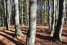
The 85.7-kilometer Franconian Dune Trail runs through the village . The 2nd stage of the Dünenweg runs from Weißenbrunn via Entenberg to Röthenbach ad Pegnitz and has a length of around 17 kilometers. The long-distance hiking trail of the Franconian Alb Association is called Hiking in the Beech Forest in this section . The ridge from Entenberg Sattel to Balcher leads through a beech forest . The eponymous European beech ( Fagus sylvatica ) is the dominant tree species on the Malm and Dogger locations.
Bike path
The village is connected to numerous cycle paths. For example, cycle route 11 in the district of Nürnberger Land (route ID: 9147) runs through Entenberg. Between Henfenfeld, Engelthal and Offenhausen there is also a high trail (trail ID: 23106) that is connected to Entenberg. The profiled cycle path leads through the Jura landscape of Entenberg and is suitable for mountain bikers due to the route.
Winter sports
In winter, depending on the weather, there are two tow lifts with a length of 260 and 280 meters.
Architectural monuments
Parish Church of St. Peter and Paul
The Evangelical Lutheran parish church of St. Peter and Paul in the northwest of the town center characterizes the townscape and landscape of Entenberg and is the most important architectural monument in the village (D-5-74-139-22). The core of the nave of the sacred building dates from the 13th century and the choir tower from the 14th century. The medieval church was renovated from 1723. The choir was equipped with a deep ribbed vault and the vaulted ceiling of the nave was spanned with an arched barrel and provided with galleries on three sides. The nave is separated from the choir by a transverse wall in front. The coat of arms of the five Nuremberg governors was depicted on the wall above the archway in 1723 by the painter Johann Christoph Reich (1679–1748). The church altar was made by Christoph Wildt in 1730. The church consists of sandstone blocks and is surrounded by a circumferential cemetery wall made of sandstone, which was probably built in the 14th century.
Former stable house
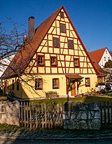
There are five architectural monuments in Entenberg, including a former stable house from the first half of the 19th century, which is designed as a massive single-storey steep saddle roof.
literature
- Friedrich Kohl (Hrsg.): Community of Leinburg with their places in the picture , community of Leinburg
- Albert Geng, Hiking in the Altdorfer Land , Tourist Association Altdorfer Land e. V.
- Nuremberg country . Karl Pfeiffer's Buchdruckerei und Verlag, Hersbruck 1993. ISBN 3-9800386-5-3
- Ronald Hotler: Around the Moritzberg . Natural History Society Nuremberg eV, Fürth 1989, ISSN 0077-6149
Web links
- Entenberg on the website of the community of Leinburg
- Entenberg in the BayernAtlas (accessed on November 9, 2017)
- Duck mountain on a historical map (accessed on Nov. 9, 2017)
Individual evidence
- ↑ a b Population (2016) of Entenberg on the website of the municipality of Leinburg.
- ↑ Entenberg in the local database of the Bayerische Landesbibliothek Online (accessed on Nov. 9, 2017)
- ↑ Geographical location of Entenberg (accessed on Nov. 9, 2017)
- ↑ Map of the main natural space units and natural space units in Bavaria. (PDF) Bavarian State Office for the Environment, accessed on October 27, 2019 .
- ↑ Landscape profile: 8102 Middle Franconian Alb between Regensburg and Offenhausen. In: Landscapes worthy of protection. Federal Agency for Nature Conservation, March 1, 2012, accessed on October 28, 2019 .
- ↑ Interactive map service (web mapping) on the landscapes in Germany. Federal Agency for Nature Conservation, November 21, 2014, accessed on November 3, 2019 .
- ↑ Digital geological map of Bavaria 1: 25,000 (dGK25). In: BayernAtlas. Bavarian State Office for the Environment; State Office for Digitization, Broadband and Surveying, accessed on October 27, 2019 .
- ↑ Overview soil map of Bavaria 1: 25,000. In: BayernAtlas. Bavarian State Office for the Environment; State Office for Digitization, Broadband and Surveying, accessed on October 27, 2019 .
- ^ Offenhausen: Offenhausen Geography. DB-City, 2019, accessed on October 27, 2019 .
- ↑ Landscape protection areas. In: BayernAtlas. Bavarian State Office for the Environment; State Office for Digitization, Broadband and Surveying, accessed on October 27, 2019 .
- ↑ Legal ordinance for the designation of the landscape protection area "Southern Jura with Moritzberg and surroundings". In: Ordinance. District of Nürnberger Land, November 8, 1985, accessed October 19, 2019 .
- ↑ a b First recording sheets of the real estate cadastre of the Kingdom of Bavaria (1808 to 1864). In: BayernAtlas. State Office for Digitization, Broadband and Surveying, accessed on November 3, 2019 .
- ↑ aerial photo + parcel map. In: BayernAtlas. State Office for Digitization, Broadband and Surveying, accessed on November 3, 2019 .
- ↑ Ronald Heissler: Around the Moritzberg . Page 96
- ↑ Brief description of Entenberg on the website of the municipality of Leinburg (accessed on Nov. 9, 2017)
- ↑ Political composition of the rural community Entenberg (accessed on November 9, 2017)
- ↑ Historical municipality directory for the Federal Republic of Germany (1970-1982) . Page 720
- ↑ a b Figures, data & facts: General statistical information from 2018. Municipality of Leinburg, accessed on October 27, 2019 .
- ↑ Population (1910) of the Entenberg community, community register , Nuremberg district office
- ^ A b Michael Rademacher: German administrative history from the unification of the empire in 1871 to the reunification in 1990. Population of the Entenberg community. (Online material for the dissertation, Osnabrück 2006).
- ↑ Population of Entenberg on the website of the Bayerische Staatsbibliothek (accessed on Nov. 9, 2017)
- ^ Population of Entenberg (1987) on the website of the Verein für Computergenealogie e. V. ( Page no longer available , search in web archives ) Info: The link was automatically marked as defective. Please check the link according to the instructions and then remove this notice. (accessed on Nov. 9, 2017)
- ↑ The Franconian Dune Path. Nürnberger Land Tourismus, accessed on October 27, 2019 .
- ↑ a b hiking trails. In: BayernAtlas. State Office for Digitization, Broadband and Surveying, accessed on October 27, 2019 .
- ↑ Cycle paths: Route ID 9147. In: BayernAtlas. State Office for Digitization, Broadband and Surveying, accessed on October 27, 2019 .
- ↑ Cycle paths (Freizeitwege (BVV)): Path ID 23106. In: BayernAtlas. State Office for Digitization, Broadband and Surveying, accessed on October 27, 2019 .
- ↑ Entenberg ski lift (accessed on Nov. 9, 2017)
- ↑ a b List of monuments in Leinburg. Bavarian State Office for Monument Preservation, October 17, 2019, accessed on October 27, 2019 .
- ↑ a b Tilman Breuer, Friedrich Oswald, Friedrich Piel, Wilhelm Schwemmer: Handbook of German art monuments . Ed .: Dehio Vereinigung eV 2nd edition. Bavaria I: Franconia. Deutscher Kunstverlag (DKV), 1999, ISBN 978-3-422-03051-0 , p. 325 .
- ↑ Christiane Schlenk: St. Peter and Paul Church Entenberg. Evangelical Luth. Parishes of Leinburg and Entenberg, accessed on November 3, 2019 .


