Oberhaidelbach
|
Oberhaidelbach
Community of Leinburg
Coordinates: 49 ° 27 '2 " N , 11 ° 20' 56" E
|
|
|---|---|
| Height : | 397 (396-406) m above sea level NN |
| Residents : | 194 (2016) |
| Incorporation : | May 1, 1978 |
| Postal code : | 91227 |
| Area code : | 09120 |
|
The Leinburg district of Oberhaidelbach
|
|
Oberhaidelbach is one of 17 officially named districts of the community of Leinburg in Middle Franconia .
geography
The village is located at the exit of a small valley basin, which is framed in the north by the Nonnenberg and Buchenberg and in the south by the Balcher . The place is located about three kilometers east of the center of Leinburg and is at an altitude of 397 m above sea level. NHN .
history
Oberhaidelbach was first mentioned in 1236, after which it was listed several times in other medieval documents. The name of the place indicates that there were many blueberry bushes on the banks of the Haidelbach, which crosses the place . The place was from the beginning a rural settlement, the local knights of Haidelbach in the beginning were subordinate as servants to the Reichsministeriale von Thann. In the following period there were several changes of rule by various noble families.
A profound turning point in local history took place in 1504 during the Landshut War of Succession . In that year the village, like many other places in the area, was occupied by the troops of the imperial city of Nuremberg . With the conclusion of peace a year later, it finally came into the possession of this imperial city and then belonged to its land area for almost three centuries. Together with the neighboring towns, Oberhaidelbach became part of Ansbach-Bayreuth in 1796 and thus Prussian, before it became Bavarian with the annexation of Nuremberg by the Kingdom of Bavaria in 1806 .
Due to the administrative reforms carried out in the Kingdom of Bavaria at the beginning of the 19th century , Oberhaidelbach became an independent rural municipality with the second municipal edict. In the course of the municipal territorial reform in Bavaria carried out in the 1970s , the municipality of Oberhaidelbach was incorporated into the municipality of Leinburg on May 1, 1978. In 2016 Oberhaidelbach had 194 inhabitants.
Population development in the (former) municipality of Oberhaidelbach
| year | 1910 | 1933 | 1939 | 1961 | 1987 | 2016 |
|---|---|---|---|---|---|---|
| population | 184 | 162 | 176 | 201 | 180 | 194 |
traffic
The connection to the public road network is made by the state road 2404 , which comes from the south through the western local area and continues in a northerly direction to Gersdorf . A municipal road branches off from this road in Oberhaidelbach, which connects the place with the neighboring village of Entenberg , about one and a half kilometers to the east .
Architectural monuments
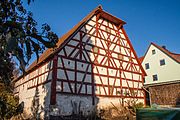
There are three architectural monuments in Oberhaidelbach, including a barn, which probably dates from the first half of the 18th century.
See: Monuments in Oberhaidelbach
literature
- Friedrich Kohl (Hrsg.): Community of Leinburg with their places in the picture , community of Leinburg
- Albert Geng: Hiking in Altdorfer Land , Tourist Association Altdorfer Land e. V.
- Nuremberg country . Karl Pfeiffer's Buchdruckerei und Verlag, Hersbruck 1993. ISBN 3-9800386-5-3
- Ronald Hotler: Around the Moritzberg . Natural History Society Nuremberg eV, Fürth 1989, ISSN 0077-6149
Web links
- Oberhaidelbach on the website of the municipality of Leinburg (accessed on November 10, 2017)
- Oberhaidelbach in the BayernAtlas (accessed on November 10, 2017)
- Oberhaidelbach on a historical map (accessed on November 10, 2017)
Individual evidence
- ↑ a b Population (2016) of Oberhaidelbach on the website of the community of Leinburg.
- ↑ Oberhaidelbach in the local database of the Bayerische Landesbibliothek Online (accessed on Nov. 10, 2017)
- ↑ Geographical location of Oberhaidelbach (accessed on November 10, 2017)
- ↑ Brief description of Oberhaidelbach on the website of the municipality of Leinburg (accessed on November 10, 2017)
- ↑ Ronald Heissler: Around the Moritzberg . Page 96
- ↑ Political composition of the rural community Oberhaidelbach (accessed on November 10, 2017)
- ↑ Historical municipality directory for the Federal Republic of Germany (1970-1982) . Page 720
- ↑ Population (1910) of the municipality of Oberhaidelbach, municipality directory , Nuremberg district office
- ^ A b Michael Rademacher: German administrative history from the unification of the empire in 1871 to the reunification in 1990. Population of the municipality of Oberhaidelbach. (Online material for the dissertation, Osnabrück 2006).
- ↑ Population of Oberhaidelbach (1961) on the website of the Bayerische Staatsbibliothek (accessed on November 10, 2017)
- ^ Population of Oberhaidelbach (1987) on the website of the Verein für Computergenealogie e. V. ( Page no longer available , search in web archives ) Info: The link was automatically marked as defective. Please check the link according to the instructions and then remove this notice. (accessed on November 10, 2017)

