Kucha (Offenhausen)
|
Kucha
Community Offenhausen
Coordinates: 49 ° 25 ′ 52 ″ N , 11 ° 25 ′ 5 ″ E
|
|
|---|---|
| Height : | 423 (416–456) m above sea level NN |
| Residents : | 248 |
| Incorporation : | May 1, 1978 |
| Postal code : | 91238 |
| Area code : | 09158 |
|
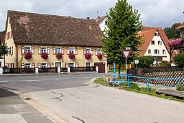
Town center
|
|
The village of Kucha is a district of the Offenhausen community in the central Franconian district of Nürnberger Land .
geography
Geographical location
Kucha is located in a small valley basin in the Hammerbachtal, around 2 kilometers south of Offenhausen and around 7 kilometers northeast of Altdorf near Nuremberg . The village is located in the area of the Albtrauf in the south of the Hersbrucker Switzerland , which is part of the Franconian Alb within the south-west German step country . In the northeast of Kucha rises the 554.0 meter high Asselberg and in the northwest the mountain plateau of the Keilberg borders with a height of 547.2 m above sea level. NN the place .
Natural allocation
In terms of nature, Kucha belongs to the northern part of the Middle Franconian Alb (Meynen / Schmithüsen et al.) . According to the natural division of Germany (Axel Ssymank) , the Middle Franconian Alb is a natural area unit in the main natural area unit, the Franconian Alb .
geology
The Jura landscape of Kucha is geologically determined by layers from the Braunjura group (Dogger). In the deeper layers characterize blue to dark gray clay and Tonmergelsteine with Toneisenstein - concretions from the Opalinuston formation (Dogger Alpha) the landscape. Above this are fine to medium-grain sandstone layers with iron ore seams from the iron sandstone formation (Dogger Beta). The mountain tops of the Asselberg and Keilberg consist of layers of the Weißjura group (Malm). The Hammerbachtal is covered with Quaternary valley fillings.
ground
In the flood plains have Gleye and other groundwater-influenced soils with Talsedimenten from silt to clay developed. Brown earth has developed as a soil type on the Braunjura rocks . On the lime-rich plateaus from Malm, shallow Rendzina soils are decisive and in the transition areas below, the two soil types Regosol and Brown Earth Regosol predominate.
climate
Kucha is located in the cool, temperate climate zone and has a humid climate . The landscape of the village is located in the transition area between the humid Atlantic and the dry continental climate . After the climate classification of Köppen / Geiger Kucha belongs to the temperate warm rainy climate (Cfb climate). The mean air temperature of the warmest month remains below 22 ° C and that of the coldest month above -3 ° C.
Flowing waters
The Hammerbach, which runs in the east, flows through Kucha in a north-south direction. The structured stream course meanders and is only moderately changed according to the water structure quality mapping . The accompanying trees are recorded in the biotope mapping and are valuable in terms of nature conservation.
history
Until it was incorporated in 1978 as part of the regional reform in Bavaria , Kucha was an independent municipality.
Culture and sights
- The Keilberg with the St. Ottmar and St. Ottilien chapel ruins
- Kneipp fountain on the outskirts
Others
- Kucha has a volunteer fire brigade , a snuff club , an Evangelical rural youth and the Liederkranz choral society
literature
- Nuremberg country . Karl Pfeiffer's Buchdruckerei und Verlag, Hersbruck 1993. ISBN 3-9800386-5-3
Web links
Individual evidence
- ^ BayernAtlas. State Office for Digitization, Broadband and Surveying, accessed on December 22, 2019 .
- ↑ Map of the main natural space units and natural space units in Bavaria. (PDF) Bavarian State Office for the Environment, accessed on October 13, 2019 .
- ^ Landscapes in Germany - BfN. In: Interactive map service (web mapping) on the landscapes in Germany. Federal Agency for Nature Conservation (BfN), November 21, 2014, accessed on December 22, 2019 .
- ↑ Digital geological map of Bavaria 1: 25,000 (dGK25). In: BayernAtlas. Bavarian State Office for the Environment, State Office for Digitization, Broadband and Surveying, accessed on December 22, 2019 .
- ↑ Overview soil map of Bavaria 1: 25,000 (ÜBK25). In: Soil - Environment Atlas Bavaria. Bavarian State Office for the Environment, accessed on December 22, 2019 .
- ^ Offenhausen: Offenhausen Geography. DB-City, 2019, accessed on December 22, 2019 .
- ↑ Water structure mapping of the rivers in Bavaria 2017 (on-site procedure). In: BayernAtlas. Bavarian State Office for the Environment, Bavarian Surveying Administration, March 2019, accessed on December 24, 2019 .
- ↑ Biotope mapping (plains). In: BayernAtlas. Bavarian State Office for the Environment, Bavarian Surveying Administration, accessed on December 24, 2019 .

