Grub (Burgthann)
|
Grub
Community Burgthann
Coordinates: 49 ° 20 ′ 25 ″ N , 11 ° 22 ′ 41 ″ E
|
|
|---|---|
| Height : | 468-526 m above sea level NN |
| Residents : | 612 (Nov. 2, 2017) |
| Incorporation : | July 1, 1972 |
| Postal code : | 90559 |
| Area code : | 09187 |
|
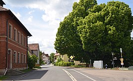
Village linden in Grub (Burgthann)
|
|
Grub is a district of the municipality Burgthann in the district of Nürnberger Land in Middle Franconia ( Bavaria ).
The village is about 5 kilometers southeast of Burgthann.
history
With the community edict (1808), Grub became a politically independent community to which the place Großvoggenhof belonged. On July 1, 1972, this was incorporated into Burgthann as part of the Bavarian regional reform .
Population development
| year | 1910 | 1933 | 1939 | 2013 | 2017 |
|---|---|---|---|---|---|
| population | 268 | 257 | 237 | 585 | 612 |
Architectural monuments
See: Monuments in Grub
literature
- Nuremberg country . Karl Pfeiffer's Buchdruckerei und Verlag, Hersbruck 1993. ISBN 3-9800386-5-3
Web links
- Grub on the Burgthann website (accessed August 15, 2012)
Individual evidence
- ↑ www.burgthann.de, Population figures October 2017 ( Memento of the original from November 13, 2017 in the Internet Archive ) Info: The archive link was inserted automatically and has not yet been checked. Please check the original and archive link according to the instructions and then remove this notice.
- ^ Wilhelm Volkert (ed.): Handbook of Bavarian offices, communities and courts 1799–1980 . CH Beck, Munich 1983, ISBN 3-406-09669-7 , p. 542 .
- ^ Community directory , District Office Nuremberg
- ^ A b Michael Rademacher: German administrative history from the unification of the empire in 1871 to the reunification in 1990. City and district of Nuremberg. (Online material for the dissertation, Osnabrück 2006).

