Pattenhofen
|
Pattenhofen
Community Burgthann
Coordinates: 49 ° 21 ′ 35 ″ N , 11 ° 18 ′ 15 ″ E
|
|
|---|---|
| Height : | 359–409 m above sea level NN |
| Residents : | 147 (Jun 6, 2020) |
| Postal code : | 90559 |
| Area code : | 09183 |
|
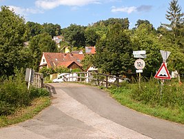
Pattenhofen, view from the south
|
|
Pattenhofen is a district of the municipality Burgthann in the district of Nürnberger Land , Middle Franconia , Bavaria .
Geographical location
The village is located on the connecting road between Burgthann and the Schwarzenbruck district of Ochenbruck, which runs in the Schwarzach valley .
Pattenhofen has a rural character. There are no shops or inns in town. One property has been designated as a historical building by the Bavarian State Office for Monument Preservation .
history
Pattenhofen was probably founded in the 10th century. The name of the village goes back to the personal name Patto or Patufried . The place was first mentioned in 1289 as the court of Patufrid . Nine properties were recorded in the 16th century.
In the past, hops and viticulture and the dairy industry were practiced on the slopes of the valley . The residents went to church until 1610 in Altdorf . Afterwards the services took place in the church of Altenthann .
During the Thirty Years' War , the town was hit hard by the plague in 1634 .
Church membership has long been a problem. Before 1806, the areas north of the Schwarzach belonged to the imperial city of Nuremberg and the southern areas to the principality of Ansbach . The farms belonged to Nuremberg and the fields and fields to Ansbach , which often led to disputes. When it was incorporated into the Kingdom of Bavaria in 1806, Pattenhofen then belonged to Altenthann .
Pattenhofen belonged to Altenthann until December 31, 1971 ( Bavarian regional reform ) . The community of Burgthann joined the place after a unanimous vote by the citizens.
Surroundings
Pattenhofen is bordered to the south by the Schwarzach.
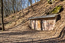
Bumberer rock cellar
The Felsenkeller Bumberer is located about 500 meters northeast of Pattenhofen. The rock cellar driven into the sandstone belonged to the abandoned Pattenhofen "Gasthaus zum Felsenkeller" until 1963. It was used as a storage and summer cellar . Because of the noise generated by a ram from a nearby source pump, the basement was popularly called Bumberer (bumble for knocking). In the 2010s the cellar was restored and used twice for local events. The plan of permanent revitalization was abandoned. The cellar is privately owned and locked.
Source at the Bumberer
A stratified spring is located directly at the rock cellar . The richly pouring spring, which was taken in 1920, served to supply the Altenthanner farms with water . The water was pumped up to the higher courtyards by means of two rams. Today the spring drains into a small stream that flows into a pond after 100 meters. The outflow from the pond then drains into the Schwarzach after 200 meters.
Web links
Individual evidence
- ↑ Pattenhofen on www.burgthann.de , accessed on June 19, 2020
- ^ Wilhelm Volkert (ed.): Handbook of Bavarian offices, communities and courts 1799–1980 . CH Beck, Munich 1983, ISBN 3-406-09669-7 , p. 542 .
- ↑ a b excursion script, Of quarries, mines, caves and springs. , Bernd Mayer (graduate geologist), edition October 7, 2018
- ↑ Information board about Pattenhofen on site
- ↑ bumble for knock
- ↑ Hans Wedel. Burgthann: History, stories and notes from the villages of the large community. Burgthann 1982, p. 172
- ↑ n-land.de/, When the Bumberer water was still a bone of contention (accessed on March 7, 2019)
- ↑ Situation in the BayernAtlas (accessed on March 7, 2019)


