Werderau
|
Werderau
Statistical District 46 City of Nuremberg
Coordinates: 49 ° 25 ′ 20 ″ N , 11 ° 3 ′ 34 ″ E
|
|
|---|---|
| Height : | 315 m above sea level NN |
| Area : | 1.52 km² |
| Residents : | 4851 (December 31, 2015) |
| Population density : | 3,191 inhabitants / km² |
| Postal code : | 90441 |
| Area code : | 0911 |
|
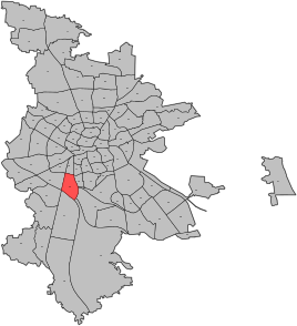
Location of the statistical district 46 Werderau
|
|
|
Werderau Volckamerstraße 3,4
|
|
Werderau is a district in the south of Nuremberg and the name of the statistical district 46. Together with the Marterlachsiedlung, Werderau has more than 4800 inhabitants and belongs to Nuremberg's postal code district 90441.
geography
The Werderau is framed by Nopitschstrasse (Südring), the A73 , the Südwesttangente and the Treuchtlingen – Nuremberg railway line , starting in the north and clockwise . The tracks of the marshalling yard divide the district into a northern and a southern part. In the public consciousness, often only the southern part is seen as Werderau.
| Neighboring statistical districts | |||||||||
|---|---|---|---|---|---|---|---|---|---|
|
history
From 1910/11, a residential complex for workers and senior employees of the MAN company was built on the site of the Gibitzenhof community, which was incorporated into Nuremberg in 1899 . The founding of Werderau was an idea by Anton von Rieppel , who was then general manager of MAN. The settlement got its name from the technician Johann Ludwig Werder . In order to achieve the most natural urbanity possible, angled buildings were built around a central square, the Volckamerplatz, on which a monument was erected to Anton von Rieppel. The construction phase dragged on until the 1930s. The architect Ludwig Ruff was also involved in many other buildings in Nuremberg.
Attractions
- Monument to the founder Anton von Rieppel
literature
- Nikolaus Bencker: Werderau . In: Michael Diefenbacher , Rudolf Endres (Hrsg.): Stadtlexikon Nürnberg . 2nd, improved edition. W. Tümmels Verlag, Nuremberg 2000, ISBN 3-921590-69-8 ( complete edition online ).
Web links
Individual evidence
- ^ City of Nuremberg, Office for Urban Research and Statistics for Nuremberg and Fürth (ed.): Statistical Yearbook of the City of Nuremberg 2016 . December 2015, ISSN 0944-1514 , 18 Statistical City Districts and Districts, p. 244–245 , p. 244 ( nuernberg.de [PDF; 6.3 MB ; accessed on November 1, 2017]).


