Königshof (Nuremberg)
|
Royal Court
Statistical District 491 City of Nuremberg
Coordinates: 49 ° 24 ′ 38 " N , 11 ° 7 ′ 43" E
|
|
|---|---|
| Height : | 329–339 m above sea level NN |
| Area : | 4 km² |
| Residents : | 28 (1950) |
| Population density : | 7 inhabitants / km² |
| Incorporation : | 1972 |
| Postal code : | 90451 |
| Area code : | 0911 |
|
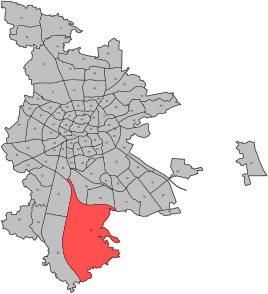
Location of the statistical district 49 Kornburg, Worzeldorf
|
|
The Königshof is a former estate in the southern outskirts of Nuremberg and gives its name to the statistical district 491, which is part of the statistical district 49 ( Kornburg, Worzeldorf ).
geography
location
The Königshof district is bounded by the Main-Danube Canal to the west and the Ludwig-Danube-Main Canal to the east. In the south, the recent meadows of the oak forest trench separate the district from the neighboring villages of Weiherhaus and Herpersdorf . In the north, the federal highway 73 forms the border. In addition to Gut Königshof, the district includes the district of Pillenreuth and parts of the Eibacher Forest . The Königshof allotment garden colony is located in the northeast. The 24.2 hectare complex is the largest allotment garden in the city with 491 parcels .
The highest elevation in the landscape is the rubble of the old Föhrenbuck landfill with a height of 369 m above sea level. NN , which is located east of the port of Nuremberg . The rubble, planted with young trees, offers a good view of Nuremberg and the surrounding area. South of the old landfill is the Nürnberg Süd waste disposal site.
geology
Pleistocene river gravel and drifting sands characterize the diverse structured landscape as geological units. In the area of the two rivers Eichenwaldgraben and Entengraben, Quaternary valley fillings are decisive.
In the vicinity of the two streams and to the north of the old landfill, Gley soils with a partly boggy character have developed. Brown earth occurs on a large scale on the sites of Gut Königshof .
history
19th century
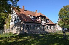
The Königshof mansion was built in 1814 by Paul Christoph von Oelhafen on the east bank of the Great Koenigsweiher near Pillenreuth on a slight hill. The manor is named after the drained pond . The extension of the Königsweiher covered 108.5 acres , which corresponds to around 27 hectares. This made the body of water significantly larger than the Dutzendteich . The royal court belonged to the Weiherhaus manor complex until 1812. The patrician family Oelhafen von Schöllenbach had acquired this from the indebted widow of the Nuremberg council member Karl Wilhelm Welser von Neunhof. The Oelhafen von Schöllenbach brothers had already bought several mansions and agricultural goods around Nuremberg. Shortly after the acquisition, they drained the ponds in order to be able to use the wetlands more profitably for agriculture. For better management of the property, the manor house was built as a "simple, single-storey sandstone block with a gable roof and gable framework". The Ströbel family from Reichelsdorf leased the farm. After 1852, the toy manufacturer Röhser owned the Königshof estate and carried out extensions.
20th century
In the 20th century, a half-timbered bay was added over the entrance area. The ground floor of the manor house was redesigned in 1906 by Oskar Weigel from Nuremberg in the old German style with wood paneling.
The property belonged to the municipality of Worzeldorf until 1972 and in 1950 had 28 residents in two properties.
In 1970 a development plan was drawn up in anticipation of the planned incorporation and it was approved in December 1971. The plan provided for a residential development of the area. In 1972 Worzeldorf was incorporated into Nuremberg. At the instigation of the city of Nuremberg, the development plan was declared void by the Bavarian Administrative Court in 1992 due to serious legal and procedural defects.
Garden area
To the east of the manor house, a representative garden with a symmetrical orientation was laid out in the 19th century. Today, only the surrounding trees are reminiscent of the former facility.
Current condition
The buildings of the Königshof estate are in a very dilapidated condition. Safety measures are necessary in order to preserve the listed buildings. The community of owners has already submitted an application to demolish an outbuilding, which was rejected by the Lower Monument Protection Authority.
The agricultural open spaces are still used intensively for agriculture.
Protected areas
Nature reserves
Gut Königshof
Due to its nature conservation value, the Königshof estate with its surrounding 76 hectares of open spaces in the form of meadows, fields, hedges and ponds was designated as a nature reserve in 1992. However, as early as 1997, following a lawsuit by the owner, the protected area had to be lifted again, as the natural area had been devalued due to intensified agricultural use. The swampy meadows were degraded to low-species fat meadows . Numerous water-bearing trenches were deepened, as a result of which the water table sank and the water-shaped biotopes were impaired.
Sand pits at Föhrenbuck
The 22.4-hectare nature reserve Sandgruben am Föhrenbuck is located south of the waste disposal site. The Marthweg delimits the protected area in the west and the Wiener Straße represents the southern border. The former sand mining site with surrounding forests was designated as a nature reserve by the government of Middle Franconia in 1992. As an undisturbed sand habitat, the abandoned mining sites offer suitable, nutrient-poor site conditions for a large number of endangered animal and plant species.
Landscape protection area
The 824 hectare landscape between the Main-Danube Canal in the west, Münchener Strasse and Schwanstetter Strasse in the east, Kettelersiedlung in the north and Pillenreuth , Herpersdorf and Worzeldorf in the south is designated as the Königshof landscape protection area. Part of the protected area is the historic Königshof estate with the surrounding agricultural and forestry areas covering around 50 hectares.
European bird sanctuary
Large parts of the forest-dominated landscape area have been reported to the European Commission as the European bird sanctuary Nuremberg Reichswald and are now subject to the strict European protection regime.
literature
- Gustav Voit: royal court . In: Michael Diefenbacher , Rudolf Endres (Hrsg.): Stadtlexikon Nürnberg . 2nd, improved edition. W. Tümmels Verlag, Nuremberg 2000, ISBN 3-921590-69-8 ( complete edition online ).
Individual evidence
- ↑ StA regional divisions Nuremberg. City of Nuremberg, accessed on January 28, 2018 .
- ^ Allotment gardens of the city of Nuremberg. (No longer available online.) City of Nuremberg, Building Department, August 2011, archived from the original on January 29, 2018 ; accessed on January 28, 2018 . Info: The archive link was inserted automatically and has not yet been checked. Please check the original and archive link according to the instructions and then remove this notice.
- ^ BayernAtlas. State Office for Digitization, Broadband and Surveying, Bavarian Surveying Administration, accessed on January 28, 2018 .
- ↑ UmweltAtlas Bayern: Map topic Applied Geology. Bavarian State Office for the Environment (LfU), accessed on September 8, 2017 .
- ↑ UmweltAtlas Bayern: Map topic soil. Bavarian State Office for the Environment (LfU), accessed on September 8, 2017 .
- ^ A b Robert Giersch, Andreas Schlunk, Bertold von Haller: Castles and mansions in the Nuremberg countryside . 1st edition. Altnürnberger Landschaft e. V., Nuremberg 2006, ISBN 978-3-00-020677-1 , p. 228 f .
- ↑ City Archives
- ^ Legal Office of the City of Nuremberg: 50 Years 1955 - 2005. From the beginning until today. City of Nuremberg, December 2005, accessed on September 9, 2017 .
- ↑ a b Monument and landscape protection in the landscape protection area Königshof. Environmental Committee of the City of Nuremberg, July 5, 2017, accessed on September 9, 2017 .
- ↑ Schmolzi Reinhard: Königshof may hope for rescue. Nürnberger Stadtanzeiger, November 30, 2016, accessed on September 9, 2017 .
- ↑ Press release BN 16/2003 Naturjuwel Königshof. Bund Naturschutz in Bayern eV, 2003, accessed on September 9, 2017 .
- ↑ "Sandgruben am Föhrenbuck" nature reserve. City of Nuremberg, Environment Agency, accessed on January 28, 2018 .
- ↑ Ordinance on the nature reserve "Sandgruben am Föhrenbuck" City of Nuremberg. Government of Middle Franconia, June 19, 1992, accessed January 28, 2018 .
- ↑ Ordinance on the establishment of landscape protection areas in the city of Nuremberg (Landscape Protection Ordinance - LSchVO). City of Nuremberg, December 21, 2010, accessed on August 6, 2017 .


