| Name / location
|
Remarks
|
image
|
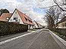
| At the Paulusstein
( Location )
|
- named after a field name
- Location of the listed Paulus stone
- central place in Buchenbühl
- connected from north to south with Kalchreuther Strasse; In the east it flows into the Froschbrücklein, in the west it flows into the Felsenkeller
|

more pictures | Wikidata
|
| At the Reichsforst
( Location )
|
- named after the neighboring Sebalder Reichswald
- runs as a southern parallel street of Waldherrenstraße with connections to it to the north
|
Wikidata
|
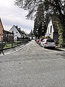
| At the Sweden Fountain
( Location )
|
- old field name in the Ziegelstein forest area
- runs from Kalchreuther Straße to the east as far as Straße Zum Froschbrücklein
|
more pictures | Wikidata
|
| Baiersdorfer Strasse
( Location )
|
- named after Baiersdorf
- leads from Märzenweg in a south-westerly direction to the street Zum Felsenkeller (open level crossing for pedestrians); the confluences of the Nuschelbergweg and Strahlfelsweg, coming from the northwest; runs parallel to the Graefenbergbahn
- Listed Church of the Assumption in No. 8/10
|

more pictures | Wikidata
|
| Buchenbühler Weg
( Location )
|
- Path from Ziegelstein to Buchenbühl
- runs east of the town center in a north-south direction and continues south as a dirt road to Ziegelstein ; western confluence of the streets Zum Steinbruch and Fuchsweg
- north of the bridge over the A3 course as a footpath to the Buchenbühl
|
Wikidata
|
| Ehrenbürgweg
( Location )
|
- named after the honorary citizen
- runs south from Märzenweg, turns into Rathsbergstrasse; eastern confluences of the Ohrwaschelweg and the Strahlfelsweg
|

more pictures | Wikidata
|
| Fuchsweg
( Location )
|
- named after the former part of the forest "Fuchsloch" near Buchenbühl
- Route from Kalchreuther Strasse to the northeast, later to the east to Buchenbühler Weg; crosses Vollandstrasse and Hermann-Löns-Strasse
|

more pictures | Wikidata
|
| Greifensteinweg
( Location )
|
- Named after a mountain in Franconian Switzerland ( Greifenstein Castle)
- runs from Wildenfelsweg from west to east parallel to Rabensteinweg; Confluence to the south in the Rabensteinweg
|

more pictures | Wikidata
|
| Hahnenbalz
( Location )
|
- named after a forest marking near Buchenbühl, where the black grouse was still common around 1895 and the capercaillie sporadically.
- Industrial area with woodwork
- branches north of the A3 to the north from Kalchreuther Strasse
|
Wikidata
|
| Hermann-Löns-Strasse
( Location )
|
- named after the poet Hermann Löns
- runs in a north-easterly direction from Kalchreuther Strasse to Zum Steinbruch; to the west of Kalchreuther Strasse is the extension of Waldherrenstrasse; runs with this from west to east as an arch south of the town center; crosses Vollandstraße and Fuchsweg
- built on with the Catholic Maria-Hilf-Kirche
|

more pictures | Wikidata
|
| Igensdorfer Strasse
( Location )
|
- named after Igensdorf
- runs in a sharp arc from Märzenweg to the southwest
|

more pictures | Wikidata
|
| Kahlbergweg
( Location )
|
- named after a 312 m high hill near Kalchreuth
- runs from the Strahlfelsweg north to the Ohrwaschelweg
|
more pictures | Wikidata
|
| Kalchreuther Strasse
( Location )
|
- named after Kalchreuth
- North-South axis of the place
- runs from the level crossing of the Graefenbergbahn on Buchenbühler Weg as an extension of Ziegelsteinstraße through Buchenbühl and north of the A3 federal motorway outside the local area of Nuremberg as Loeschweg on to Kalchreuth
- western confluences of Waldherrenstrasse, Zum Felsenkeller and Märzenweg; eastern confluence of Buchenbühler Weg and the streets Hermann-Löns-Straße, Fuchsweg, Zum Froschbrücklein (in the area of the Am Paulusstein square) and Am Schwedenbrunnen; northern confluence of the Hahnenbalz
- primary school
- Listed restaurant “Saalbau” in No. 125
|

more pictures | Wikidata
|
| Märzenweg
( Location )
|
- In memory of the work that began in March 1919 for the Buchenbühl estate
- runs in a north-westerly direction from Kalchreuther Straße to Wildenfelsweg; in the south-west two junctions of Igensdorfer Straße, Baiersdorfer Straße, Wichsensteinweg; southern confluences of the Nuschelbergweg and the Ehrenbürgweg
- is crossed by the Graefenbergbahn , stopping at the crossing until 1983
|

more pictures | Wikidata
|
| Nuschelbergweg
( Location )
|
- named after Nuschelberg
- runs from Baiersdorfer Straße north to Märzenweg; crosses the Ohrwaschelweg
|

more pictures | Wikidata
|
| Ohrwaschelweg
( Location )
|
- named after a quarry in the Tennenloher Forest that operated between 1600 and 1912
- runs from Baiersdorfer Straße west to Ehrenbürgweg; crosses the Nuschelbergweg; northern confluence of the Wichsensteinweg, southern confluence of the Kahlbergweg
|

more pictures | Wikidata
|
| Rabensteinweg
( Location )
|
- named after a mountain in Franconian Switzerland ( Rabenstein Castle )
- runs from the Wildenfelsweg from west to east parallel between Greifensteinweg and Märzenweg; It joins the Märzenweg to the south
|

more pictures | Wikidata
|
| Rathsbergstrasse
( Location )
|
- named after the Rathsberg ridge
- Extension of the Ehrenbürgweg; leads to brick is partially in brick
- Listed youth hotel at No. 300
|

more pictures | Wikidata
|
| Rays rock path
( Location )
|
- named after the Burgstall Strahlfels
- runs in a north-westerly direction from Baiersdorfer Straße to Ehrenbürgweg; northern confluence of the Kahlbergweg
|
Wikidata
|
| Vollandstrasse
( Location )
|
- named after Hermann Volland , oldest known forestry officer of the Sebalder Reichswald (14th century)
- Former prayer room and today's Protestant forest kindergarten
- runs in a south-easterly direction from the street Zum Froschbrücklein to Hermann-Löns-Straße, crosses the Fuchsweg
|
Wikidata
|
| Waldamtstrasse
( Location )
|
- named for the forest offices of the Nuremberg Reichswald (St. Lorenz and St. Sebald)
- runs parallel to the street Zum Felsenkeller from west to east as a road angled to the south, the Waldherrenstrasse crosses to the south again to Waldherrenstrasse
|
Wikidata
|
| Waldherrenstrasse
( Location )
|
- named after the committee of forest gentlemen of the Imperial City Council
- runs in a north-westerly direction from Kalchreuther Straße to Straße Zum Felsenkeller; to the west of Kalchreuther Strasse is the extension of Hermann-Löns-Strasse; runs with this from west to east as an arch south of the town center; two junctions of the Waldamtstraße in the north and east and two junctions of the street Am Reichsforst in the south
|
Wikidata
|
| Wichsensteinweg
( Location )
|
- named after the third highest point in Franconian Switzerland ( Wichsenstein ) at 578 m
- runs from Ohrwaschelweg north to Märzenweg
|
Wikidata
|
| Wildenfelsweg
( Location )
|
- named after a mountain in the Nürnberger Land ( Wildenfels)
- runs from Greifensteinweg from north to south to Märzenweg; Branch to the west to the sports field
|

more pictures | Wikidata
|
| To the rock cellar
( Location )
|
- named after a rock cellar located there
- runs from the Am Paulusstein square to the west over an unrestricted level crossing for pedestrians to Baiersdorfer Straße; southern confluence with Waldherrenstrasse
|

more pictures | Wikidata
|
| To the little frog bridge
( Location )
|
- named after a former part of the forest near Buchenbühl
- runs from the Am Paulusstein square to the northeast to the meadow area of the Buchenbühl small animal breeding association; southeast confluence of Vollandstraße and Straße Zum Steinbruch; northwest confluence of the street Am Schwedenbrunnen
- in the northeast area, a listed bridge over the Kothbrunngraben
|

more pictures | Wikidata
|
| To the quarry
( Location )
|
- named after a former quarry that is now filled with bomb rubble
- runs in an easterly direction from Zum Froschbrücklein to Buchenbühler Weg; southern confluence with Hermann-Löns-Straße
|

more pictures | Wikidata
|


