
Rathsberg
|
Rathsberg
Community Marloffstein
Coordinates: 49 ° 37 ′ 6 ″ N , 11 ° 1 ′ 27 ″ E
|
|
|---|---|
| Height : | 374–390 m above sea level NHN |
| Residents : | 500 (Jul 2, 2018) |
| Postal code : | 91080 |
| Area code : | 09131 |
.jpg) Rathsberg from above
|
|
Rathsberg (colloquially: Rådbeʳch ) is a district of the municipality of Marloffstein in the Erlangen-Höchstadt district in Central Franconia . The town and the Rathsberg Castle of the same name are located on the highest, western point of the Rathsberg ridge northeast of Erlangen.
geography
Rathsberg is located about two kilometers northeast of Erlangen , about one kilometer southeast of Bubenreuth , about one kilometer west of Atzelsberg and about three kilometers west of Marloffstein. The place is located on the district road 7 from Erlangen via Atzelsberg to Marloffstein in a westward cantilevered corner of the Atzelsberg district, which has belonged to Marloffstein since the regional reform in Bavaria , whereby the settlement boundary formed by the Meilwald on the mountain slopes to the north, west and south also essentially the district boundary forms.
The upper, wooded part of the Erlanger mountain is called Rathsberg. The lower, populated hill is called Castle Hill or Old Town Hill.
Nature reserve "Wilderness am Rathsberg"
On the wooded north-western slope of the place there are old abandoned quarries and rock debris lying around. This part of the Bischofsmeilwald received the status of a nature reserve in 1996 under the name Wildnis am Rathsberg . This serves to preserve the geological formation of the well-developed shadowy slope forest typical of Rhätolia in its partly primeval forest-like appearance and its species composition and animal species diversity. The wilderness on the Rathsberg is also part of the protected geotopes and protected fauna and flora habitats in the Erlangen-Höchstadt district.
Due to the designation as a nature reserve, this part of the Bischofswald may not be used with bicycles, riding is only permitted on paved paths, dogs are on a leash and the tranquility of nature must not be disturbed.
history
The origins of the town of Rathsberg (oldest spelling: Radsberg) can only be documented from the end of the 14th century, according to the sources available to date. The palace complex was built at the beginning of the 17th century. It was at this time that Rathsberg's first illustration on maps was made.
Place name
There are numerous conjectures about the origin of the name of the Rathsberg mountain.
The historian D. Fastnacht considers four possible origins: 1) the derivation of the personal name Ratzo , 2) the derivation of a short form of the personal name Rathbrecht, Radeboto , 3) the derivation of ratz ( mhd. For rat ), which is a nickname for a thief was needed. - With these three possibilities, the place would be named after its founder. 4) The derivation of a field name that denotes a mountain where there were many rats.
The mayor of Erlangen, Ferdinand Lammers , derived the name in 1834 from the original ownership structure of the Erlanger mountain. The Erlanger Berg was divided into two sections, of which the upper forest-covered hill was municipal property, the lower cleared hill was the private property of the citizens. The upper department was probably called the Rathsberg because the community property was usually named after the administrative authority, as was the case with the fiefdoms, which were never called community fiefs, but rather Rathslehen. The lower part was called Burgerberg to distinguish it, from which Burgberg was made.
The fact that the ridge formed the former southern border of the Radenzgau is believed to have given it its name ( Radsberg ) in 1856 .
Another attempt to explain it refers to the original Slavic population and derives the name Rathsberg from the Slavic word Hrad (castle). However, there is no evidence of a castle here or on Erlanger Burgberg.
In old topographical encyclopedias the place is also called Razenberg (1747) or Ratzenberg (1801).
Rathsberg manor
At the beginning Rathsberg consisted of a single farm with fields, which were probably created on the high plateau of the Rathsberg from clearing in the Meilwald . The farm also had wood rights there, but no grazing rights. The farm and some fields were fiefdoms of the Bamberg Dompropstei since 1419 . In addition, some fields on the Rathsberg were owned (fiefdoms) by Hohenlohe-Brauneck or, after this line of nobility in 1390, the burgraves of Nuremberg and the Hohenzollern margrave of Brandenburg-Kulmbach, which later emerged from it .
The following owners ( tenants ) can be proven:
- In 1391 Bertold von Erlangen ( lower nobility based in the village of Erlangen ) was enfeoffed by the Nuremberg burgrave with four fields on the Rathsberg. In 1394 his daughter Margaretha, married to Eberhard Ratz, took over the fief. Probably her father had passed away by now. In 1397 at the latest, Hans Mugelein was the tenant of these fields. In 1401 Lorenz Gotzmann was enfeoffed with six fields.
- The court was also owned by Bertold von Erlangen in 1391, albeit as a fief of the Bamberg cathedral provost. In 1397 the fief went to Heinrich Groß (probably Groß von Trockau ).
- In 1411 the court came to the castle counts judge Heinrich Schenk von Leutershausen.
(Georg Friedrich Hülß claims in a court file from 1722 that the von Leutershausen taverns owned it from 1300 to 1411, and afterwards that of Lichtenstein.) - Linhard von Lichtenstein bought it in 1430
- In 1431 it came to Hans von Schürstab , whose family kept it until 1600. The Schürstabs did not live in Rathsberg themselves, but only used it economically as an alpine pasture for their sheep breeding at Gut Oberndorf near Möhrendorf. Around 1435, the Bamberg bishop only mentioned the Rathsberg farm. Rathsberg was parish in Erlangen at this time. A new manor house was built around 1480. In the records of the city of Nuremberg from 1504, the farm was referred to as Nuremberg. Fortifications or a mansion are not listed and for this reason Rathsberg was probably not destroyed in the Peasants' War (1525). In 1552 it was destroyed and looted during the Second Margrave War and rebuilt in 1578.
- In 1601 Georg Siegmund and Franz Karl von Schürstab sold the estate to Georg Ludwig Fuchs zu Obernwölckersdorf . The feudal lord of the property was no longer the Margrave of Bayreuth, but the provost of Würzburg and Bamberg, Wolfgang Albrecht von Würzburg. The loan letter mentions a castle with a farm, two small estates and a brick hut.
- In 1616 Ernst Hülß (1586-1658) from Nuremberg acquired the estate as a man from cathedral provost Johann Christoph Neustetter . The loan letter mentions a small castle with a farm, three small estates and a brick hut. Rathsberg was still subject to the margravial jurisdiction of the Bayersdorf District Office.
The Hülß had the nobility diploma since 1578. Ernst Hülß was the grandson of Bamberg's mayor Jakob Hüls and the son of the Nuremberg town councilor Erbst Hüls. Ernst Hülß also had the family crypt laid out in the Erlanger Martinsbühler church. She owned her family seat in the old town church and donated the altar after the church was rebuilt after the Thirty Years' War.
Rathsberg Castle
The beginnings of the castle date back to 1601, when a "little castle" was mentioned for the first time. Only the residential buildings of the nobility were referred to as a castle , so the owner had to have a nobility diploma. From the sales notes of 1616 it is known that there was only one house outside the later castle walls.
Immediately after the acquisition, Ernst Hülß invested in his agricultural property. In 1620–1622, the residential building that still exists today was built in the Renaissance style on the site of the simple manor house . For this, Georg Wächter from Bamberg made an iron etching of the castle in 1616 based on a drawing by the Nuremberg stonemason Hans Bin , which was again slightly changed in 1621 (change of the roof bay window) by Hans Bin. In 1631, during the Thirty Years' War , imperial troops looted the castle but did not destroy it.

In 1702, Hülß's great-grandson Georg Friedrich Hülß (1676–1744) redesigned the palace and garden according to the principles of symmetry and visual axes that applied in the Baroque style . Hülß extends the castle courtyard and strengthens the surrounding walls. A retaining wall will be erected on the northern slope of the castle courtyard. The gate still preserved today with the alliance coat of arms of his family and his wife Arnoldine von Brand can be traced back to him. In 1736, legal disputes between the Hülß family led to Georg Friedrich Hülß having to vacate the estate in favor of his sister Maria Regina Wilhelmina (1674-1759). However, this lived in Erlangen and only put one manager on the estate. The previously prosperous agricultural facility including the brick factory was completely run down in the following period. When the male line of the Hülß von Rathsberg became extinct in 1765 with the death of Georg Christian Hülß, the man fief fell back to the cathedral provost. At that time the tenants were a granddaughter of Georg Friedrich von Hülß, Sophia Catherina von Schlammersdorf and her husband Wilhelm Ludwig von Brandt. Brandt is mentioned in 1765 as Lord von Rathsberg (and Adlitz ) and is matriculated in the imperial-free Franconian knight canton of Gebürg .
In 1766, Johann Friedrich Wilhelm Buirette von Oehlefeld (dubbed the Privy Councilor of the Princes of Saxony-Coburg-Saalfeld) acquired the estate. He already owned the Burgstall Strahlfels .
In 1820 Rathsberg came to Georg Christoph Albrecht von Wahler (1784–1849), who already owned Atzelsberg and combined the two estates. After Albrecht's death in 1849, his eldest daughter Mathilde (1810-1854) and her husband Hermann Friedrich Beckh (1806-1886) managed the castle property for the community of heirs.
In 1866 Beckh acquired the entire estate. He repaired it from the ground up and continued to run the farm. Since 1867 it was again economically separated from Atzelsberg.
In 1869 a four-sided roof turret (with a clockwork since 1874) and the western extension to the castle were built. The roof turret was removed again in the early 1960s.
In 1873/75 the Beckh family also acquired a large part of the Bischofsmeilwald . 1875–1909, the son Friedrich Beckh (1843–1927) managed the parental castle estate and introduced new economic methods there. In 1908 Franz Beckh Jun. Acquired the estate, which had been divided up in the meantime, from his relatives. After his death in 1959, his son of the same name, Franz Beckh (1882–1966) inherited it and in 1960 finally handed over the castle and its goods to his son Heinz Beckh (1917–1980). Under him the estate was also known for its horse breeding. The castle was finally sold by his heirs.
Even today, the castle and its economic facilities are privately owned and cannot be visited.
Rathsberg village
From the original castle hamlet that had the latest in the 18th century village Rathsberg with several Taglöhnerhäusern and a brick hut formed. The natural clay deposits on the Rathsberg formed an ideal basis for brick production.
As part of the community edict (early 19th century), Rathsberg was assigned to the tax district Uttenreuth and the rural community Atzelberg .
In the first Bavarian recording made in 1821, the brickworks (plot number 16) as well as the associated brick ponds and clay pits can be found. With the gradual spread of the modern ring kiln after 1859, however, it was hardly possible to operate conventional brickworks commercially, so that operation had to be stopped in 1896.
Health resort and local recreation area in Erlangen
As early as 1700, the place was known for its excellent views. It is surrounded on three sides by rocky slopes, some of which were created by natural slopes of the sandstone layers sliding on the clay soil (Letten); but above all through its use as a quarry for the buildings in Rathsberg and Erlangen and the construction of the Ludwig-Danube-Main Canal . The adjacent Meilwald had not yet recaptured its ancestral territory and presented no obstacle to the eye. On the plateau stretching to the east were fruit and nut trees.
In the early 19th century, a small air crank company was established in Rathsberg . Especially at the time of cherry blossom and summer freshness , the place with its nearby orchards and hop gardens, sunny forest walks and a romantic spring system is the most popular excursion destination for Erlangen and is also popular with people from Fürth and Nuremberg. In 1846 there are three hosts.
.jpg)
In 1773, Christoph Kiesewetter acquired the Brandstatt (simple house with a fireplace) immediately southeast of the Schlossplatz and set up an inn and distillery there. This later goes to the Malter family. From 1833 it served the Baruthia Corps as an ex-pub . Especially during the parish fair, there is a lot of activity here, the tradition of which continues well into the 20th century. Around 1870 the old inn was replaced by the "Old Guest House and Kurhaus", which still exists today. It was taken over by the Stahl family in 1887; from this it was acquired by August Münch and in 1919 by Rudolf Seyferth. In 1947 Osram Berlin employed 40 people in the old Kurhaus, Siemens used it in 1954 and continues to employ 30 people.
As early as the beginning of the 18th century, the brickworks in the eastern part of the old town center, in today's street Am Rundblick , was used as a tap or bar. After the brickworks went bankrupt in 1896, the spa hotel and the garden restoration “Zur Schöne Aussicht” of the Weiß family were built on the property. In 1897 the student choir, AMV Fridericiana Erlangen , chose the restaurant as an ex-pub. (The AMV existed until 1936.) In addition, the Erlangen architects Steidel and Gehring built a small, architecturally appealing dance hall in the style of a Nordic-Germanic royal hall in 1914 (1898). The garden restoration was later renamed the Cafe-Restaurant Rundblick after a change of ownership .
After 1945 Rathsberg developed into a preferred residential area. Its population has now almost quadrupled. In 1964 the little road between Erlangen and Marloffstein was expanded; in the process, bypass roads were created for the towns of Rathsberg and Atzelsberg.
On May 1, 1978 the community Atzelsberg-Rathsberg was incorporated together with Adlitz in the course of the regional reform in Bavaria to Marloffstein. Marloffstein became part of the Uttenreuth administrative community .
Tourism no longer plays a role today. The touristic past can only be admired on old postcards. The famous panoramic and distant view is now obscured by the surrounding forests. The fortified spring in the wilderness has fallen into disrepair. The former spa and guest houses, the dance hall and the castle are now listed residential buildings.
However, the residents of Erlangen continue to use the nearby parking spaces as starting points for walks across the ridge past Atzelsberg to Marloffstein. Here you can still enjoy the lovely views that attracted so many people to the Rathsberg in the 19th century.
Historical views

The north side of the castle and the entrance side with the Malter inn, around 1850

View of Rathsberg, ca.1900
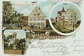
Economy at the castle and observation tower, approx. 1900

Hotel for a beautiful view with garden restaurant, around 1900
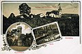
Kurhotel Weiss, observation tower, spring in the wilderness, approx. 1900

Kurhaus and Restaurant Weiss, observation tower, around 1900
.jpg)


Interesting episodes
Luderhaus and Luderloch
In the Bavarian first photograph created in 1821, forest and arable land of a Luderhaus are drawn. The term slut was originally used for animal carcasses that were used as bait for predatory game. Accordingly, the skinner's place of work was often called the Luderhaus . The place where the animal carcasses were buried was called Luderacker . In addition, Luderhaus can also refer to a hunting lodge (at Luderplatz ), a dog kennel (for feeding animal carcasses) or later, due to the changing usage of language, a brothel.
In the 15th and 16th centuries, the Rathsberger Gut was used by the Schürstabs for their sheep. At that time, shepherds removed sheep carcasses far outside the villages themselves and often took on the dishonorable masking for the surrounding areas. The remote location of the farm and its use as a sheep farm suggest that this property was originally used for dumping or for recycling animal carcasses.
On the border between Rathsberg and the Luderhauswald was the Luderloch , a small, abandoned quarry in which water collected. Although it has dried up in the meantime, its name has survived to this day and is often interpreted mystically, also in the sense of the meanwhile changed linguistic usage.
Georg Friedrich Hülß and the Prussian fortress Rathsberg
In 1705 the Prussian King Friedrich I received an anonymous letter from Erlangen, which tried to make the purchase of Rathsberg Castle attractive to him. Due to its elevated and central location, the Rathsberg is ideal for a fortress. In addition, the castle is characterized by its idyllic location in the middle of light forests and orchards and could therefore also be used as a princely pleasure house. The king then had the place examined more closely by the Baron von Reichenbach. Reichenbach suspected the then owner Georg Friedrich Hülß as the author of the letter and advised the king a. a. because of the difficult ownership situation.
From Reichenbach's letter and a Bayersdorfer court ruling from 1722 on the estate of a military man who died in Rathsberg, an ongoing conflict between Hülß and the Bayersdorf margravial-Bayreuth office responsible for the area can be seen. Hülß was registered in the imperial Franconian knight canton of Gebürg and claimed the privileges of a manor for his Rathsberg possessions . Before, this was primarily associated with tax advantages for him. On the other hand, it withdrew power and sources of income from the rulers of Bayreuth and was therefore questioned wherever possible. Since Rathsberg was a cathedral provost-Bamberg fief, the Bayersdorfer bailiff had to accept that he would not receive any taxes from Hülß, but he never recognized any further privileges (e.g. bailiff's rights) or the status of a manor itself. Probably for this reason the reinforcement of the fortifications of the castle was watched with a lot of suspicion and he waited for an opportunity to have parts of it torn down again.
But there were also legal disputes within the Hülß family. Hülß had already invested heavily in the estate as a young man (since 1702), but was apparently so heavily indebted to his sister Maria Regina Wilhelmina, widowed chamberlain, that she forced the 60-year-old Hülß to vacate the estate with his family in 1736. The dispute continued, however, because the sister was not interested in the long-term preservation of the property (she did not live in it herself), but only in the income associated with it. Mutual reports of insult, assault and mismanagement followed until Hülß's death in 1744. Even after that, there were ongoing inheritance disputes, which finally ruined the family financially and left the castle property to decay.
Rubnerstein
At the edge of the forest in the northwest of Rathsberg is a memorial stone carved from sandstone.

It recalls a duel that took place after Whitsun, on June 1, 1841 at 6 a.m. between the student Carl Friedrich Wilhelm Rubner ( Corps Baruthia , born April 12, 1821) and the theology student Karl Ludwig Thuerecht Köberlin ( Burschenschaft Bubenruthia , 1821 –1896) took place. The reason for this duel was a heated argument at the Erlangen Bergkirchweih . Shortly after the duel began, Rubner was fatally struck by a rapier in the chest. The body was hidden in the bushes to keep his death secret for as long as possible. This should enable his opponent to escape.
Two girls found the dead on June 4, 1841. Judicial investigations did not solve the problem. Rubner's corpse was buried on June 5, 1841, with the participation of all students, but without singing and without a blessing in the Neustädter Friedhof.
Rubner's connection, Corps Baruthia , erected a memorial stone before 1900 on specially acquired land, which was renewed in 1928. The memorial stone shows the circle of connection, a thrusting sword, Rubner's name and the date of his death.
As far as is known, Rubner's opponent Köberlin was last rector at a trade school in Schweinfurt and died of natural causes in 1896.

Memorial plaque Mathilden
In the north on the rock at the foot of the castle wall there is a memorial plaque with the inscription "Mathilden am 12. Mai 1855". The date corresponds to the 25th wedding anniversary of the then administrator and later owner Hermann Friedrich Beckh and his wife Mathilde von Wahler. Mathilde died shortly before, on December 28, 1854, at the age of 44. On June 29, 1857 Beckh married his second wife, Sophie Cella (1828-1913).

The former observation tower on the Rathsberg
The location on the dominating ridge of the Rathsberg prompted the Erlangen non-profit association to build a 17 m high observation tower in 1885. The construction was financed by share certificates, which entitle you to free use. 5000-7000 people annually visited the tower and enjoyed the spectacular view. Sixty years later, at the end of World War II, the tower served as a military observation post. American artillery targeted higher buildings and destroyed the tower parapet, platform and main cornice as they advanced on Erlangen. Parts of the stairs and the masonry were also damaged. In order to preserve it as a symbol of the city of Erlangen, it was renovated after some time and reopened in 1949. Due to the growing mobility, the Erlanger moved more and more to more distant destinations in the years that followed. In 1972 the tower was finally demolished because it was in disrepair. Today a large wooden cross adorns the square, and it is used for forest services. The residential street to the former tower is still called "Zum Aussichtsturm".
Population development
| year | 1818 | 1840 | 1861 | 1871 | 1885 | 1900 | 1925 | 1950 | 1961 | 1970 | 1987 | 2016 | 2018 |
|---|---|---|---|---|---|---|---|---|---|---|---|---|---|
| Residents | 100 | 134 | 106 | 102 | 108 | 97 | 100 | 167 | 138 | 159 | 442 | 497 | 500 |
| Houses | 17th | 18th | 20th | 21st | 21st | 17th | 19th | 123 | |||||
| source |
Furthermore, there is further statistical information about the place or the community Atzelsberg with Rathsberg:
| date | Residents | comment | |
|---|---|---|---|
| Rathsberg | Atzelsberg | ||
| 1818 | 100 | 46 | Topography, 17 fireplaces, 20 families |
| 1829 | 100 | 46 | Topography, 1 castle, 17 fireplaces, 17 families |
| 1840 | 134 | 56 | Statistics Middle Franconia, 1 castle, 18 houses, 20 families, 3 landlords, 1 bricklayer, 1 butcher, 1 weaver |
| 1842 | 119 | 54 | Travel description, castle with 17 houses |
| January 1, 1853 | 130 | 55 | church statistics |
| January 1, 1856 | 130 | 56 | Statistics Middle Franconia, 1 castle, 18 houses, 20 families, seat of a royal forest warden, 3 landlords, 1 bricklayer, 1 butcher, 1 weaver |
| 1857 | Topography, 1 castle, 17 houses, 2 beer taverns, 1 brickworks | ||
| January 1, 1864 | 136 | 56 | Statistics Middle Franconia, 1 castle, 18 houses, 20 families |
| 1868 | 101 | 67 | Post Lexicon |
| 1873 | 101 | 67 | Post Lexicon |
| 1881 | 107 | 60 | church statistics |
| 1898 | 161 | church statistics | |
| 1918 | 134 | History summary | |
| 1925 | 152 | according to Rademacher | |
| 1933 | 142 | according to Rademacher | |
| 1939 | 131 | according to Rademacher | |
| December 1945 | 190 | History summary | |
| 1950 | 247 | History summary | |
| 1954 | 270 | History summary, 17 residential buildings | |
| April 7, 1976 | 400 | ||
| January 1988 | 508 | ||
| 4th july 2016 | 497 | ||
| 2nd July 2018 | 500 | 39 | |
Architectural monuments
- Ensemble Rathsberg Castle and its surroundings
- At Rundblick 3: sandstone block construction
- At Rundblick 9: Stadel
- At Rundblick 10: farmhouse
- At Rundblick 16: dance hall building
- Schloßweg 23 and 25: older Kurhaus
religion
The place has been mixed denominationally since the Reformation. The Lutherans are parish in the old town church (Erlangen) , the Catholics after the heart of Jesus (Erlangen) .
traffic
The district road ERH 7 runs from Burgberg to State Road 2242 (1.75 km southwest) or to Atzelsberg (1.25 km northeast).
The place is integrated into the tariff area of the transport association Greater Nuremberg (VGN) . The bus route 252 Erlangen-Baiersdorf serves the stops Schlossweg and Rathsberg-Ost.
Personalities
- Johann Heinrich Hülls (1581–1649), German lawyer, defendant at the University of Basel and counsel in Nuremberg
- Hermann Friedrich Jakob Beckh (1806–1886), politician
- Friedrich Beckh (1843–1927), politician
- Gerhard Lehnert (1930–2010), physician
literature
- Johann Kaspar Bundschuh : Ratzenberg . In: Geographical Statistical-Topographical Lexicon of Franconia . tape 4 : Ni-R . Verlag der Stettinische Buchhandlung, Ulm 1801, DNB 790364301 , OCLC 833753101 , Sp. 430 ( digitized version ).
- Johann Kaspar Bundschuh : Rathsberg . In: Geographical Statistical-Topographical Lexicon of Franconia . tape 6 : V-Z . Verlag der Stettinische Buchhandlung, Ulm 1804, DNB 790364328 , OCLC 833753116 , Sp. 869 ( digitized version ).
- Dorothea Fastnacht: Erlangen: former city and district (= historical book of place names of Bavaria, Middle Franconia . Volume 7 ). Commission for Bavarian State History, Munich 2015, ISBN 978-3-7696-6869-8 , p. 228-233 .
- August Gebeßler : City and district of Erlangen (= Bavarian art monuments . Volume 14 ). Deutscher Kunstverlag, Munich 1962, DNB 451450949 , p. 139-140 .
- Robert Giersch, Bertold Frhr. v. Haller: On the history of Rathsberg Castle , modules for Franconian local research 52, published in Erlanger, 2008
- Bertold Frhr. von Haller: Rathsberg . In: Christoph Friederich, Bertold Freiherr von Haller, Andreas Jakob (Hrsg.): Erlanger Stadtlexikon . W. Tümmels Verlag, Nuremberg 2002, ISBN 3-921590-89-2 , p. 573-574 ( full online edition ).
- Franz Krug (ed.): The district of Erlangen-Höchstadt . Publishing house for authorities a. Wirtschaft, Hof (Saale) 1979, ISBN 3-921603-00-5 , p. 156 .
- Manfred Mayer (Ed.): Marloffstein. Marloffstein - Rathsberg - Atzelsberg - Adlitz, from archives tales and legends. 1288 - 1988 , Druckhaus Mayer Publisher: Erlangen 1988, pp 249-269.
Web links
- Rathsberg in the Bavarian original cadastre (1808–1864) in the Bavaria Atlas
- Rathsberg in the location database of the Bayerische Landesbibliothek Online . Bayerische Staatsbibliothek, accessed on November 2, 2019.
- Rathsberg in the Topographia Franconiae of the University of Würzburg , accessed on November 2, 2019.
- Rathsberg in the historical gazette of the Verein für Computergenealogie , accessed on November 2, 2019
Individual evidence
- Article in the Erlanger Stadtlexikon
- ↑ a b c Bertold Freiherr von Haller: Rathsberg , p. 573f. [1]
- ^ Gertraud Lehmann: Friedrich Beckh . [2]
- ↑ a b c Andreas Jakob : Rubnerstein . [3]
- ^ Gertraud Lehmann: Hermann Friedrich Jakob Beckh . [4]
- Manfred Mayer (Ed.): Marloffstein. Marloffstein - Rathsberg - Atzelsberg - Adlitz, from archives tales and legends. 1288 - 1988, Druckhaus Mayer Verlag, Erlangen, 1988
- ↑ p. 267 f., Anonymous letter to King Friedrich I in Prussia , original source: Prussian Secret State Archives Berlin. Rp. 44. KKK. 4c
- ↑ a b c pp. 249-269. Rathsberg district
- ↑ a b c d p. 250 f .: Timeline - Rathsberg .
- Other sources
- ↑ a b D. Fastnacht, p. 232.
- ↑ a b Rathsberg in the Bavaria Atlas
- ↑ a b c Ludwig Göhring: Erlanger excursion booklet, 1910, special print 4th edition
- ↑ a b Central Franconian Official Gazette No. 14/1996, Ordinance on the "Wildnis am Rathsberg" nature reserve, Erlangen-Höchstadt district, from July 12, 1996 [5]
- ^ Website district office Erlangen-Höchstadt - Wildnis am Rathsberg
- ↑ History of the city of Erlangen from its origins under the Franconian kings to its cession to the Crown of Bavaria according to documents and official sources, edited by Ferdinand Lammers , first mayor of the city of Erlangen, Erlangen 1834, on commission from FF Palm and Ernst Enke [6]
- ^ Heinrich Haas: The Austro-Burgundions and Logionen: a contribution to the prehistory of the southern Mainland eastern Franconia . Stoll, 1856 ( google.de [accessed November 18, 2018]).
- ^ Georg Paul Hönn: Georg Paul Hönns D. Fürstl. Saxon council and bailiff in Coburg Lexicon Topographicum in which all of the Franconian Craises cities, monasteries, castles, market spots, and villages, their old and new names, locations, last-previous and present authorities and owners, spiritual and secular servants, the Sights and peculiarities, lucky and unlucky cases, freedoms, foundations, and the like, contain: collected from proven documents, writers, and genuine news . Lochner, 1747, p. 286 ( google.de [accessed on November 13, 2018]).
- ↑ JK Bundschuh, Vol. 4, Col. 430.
- ↑ a b Robert Giersch and Bertold Frhr. v. Haller: On the history of Rathsberg Castle . In: Heimat- und Geschichtsverein Erlangen eV (Hrsg.): Erlanger building blocks. To the Franconian local history research . tape 52/2008 . Heimat- und Geschichtsverein Erlangen eV, Erlangen.
- ↑ a b c d Court files Hülß von und zu Rathsberg contra von Berlichingen and Bayreuth from Nobilis Territorio Subjectus: Or various lawsuits at the highest imperial courts, Volume 2, Lumschern, 1722, page 347ff on books.google.de
- ^ New contributions to the history of the city of Nuremberg . Eigner Verlag, 1790, p. 11 and 13 ( google.de [accessed on November 13, 2018]).
- ↑ Andreas Andresen: The German Peintre-Graveur or the German painters as engravers according to their life and works, from the last third of the 16th century to the end of the 18th century, and following Bartsch's Peintre-Graveur, to Robert- Dumesnil's and Prosper de Baudicour's French peintre-engraver. With the participation of Rudolph Weigel. Publisher by Rudolph Weigel, Leipzig, 5th volume, 1878 [7]
- ↑ a b Johann Maders ... Collection of imperial court findings in imperial knighthood matters . 1783, p. 146 ff . ( google.de [accessed on November 28, 2018]).
- ↑ Varrentrapp: New genealogical-schematic Reichs- und Staats-Handbuch: before the year 1765 . Varrentrapp, 1765 ( google.de [accessed December 6, 2018]).
- ^ Website herrensitze.com - Strahlfels [8] , accessed on September 15, 2018
- ↑ Bach-Damaskinos, Ruth: Schlösser und Burgen in Mittelfranken 2003
- ↑ a b c Alphabetical index of all the localities contained in the Rezatkreise according to its constitution by the newest organization: with indication of a. the tax districts, b. Judicial Districts, c. Rent offices in which they are located, then several other statistical notes . Ansbach 1818, p. 74 ( digitized version ).
- ^ Address and statistical manual for the Rezatkreis in the Kingdom of Baiern . Buchdruckerei Chancellery, Ansbach 1820, p. 31 ( digitized version ).
- ↑ a b Rathsberg in the Bavarian first recording (1808–1864) in the BayernAtlas
- ^ Announcement on the annulment (conclusion) of the bankruptcy proceedings of the brickworks owner-married Johann Adam, Magarethe Egersdorfer zu Rathsberg in Tonindustrie-Zeitung and Keramische Rundschau: Zentralblatt für die Gesamtgebiete der Steinen und Erden, Volume 20, 1896 books.google.de
- ↑ a b c Eduard Vetter (Hrsg.): Statistical handbook and address book of Middle Franconia in the Kingdom of Bavaria . Self-published, Ansbach 1846, p. 87 ( digitized version ).
- ^ Corps Baruthia website - History - accessed September 14, 2018
- ↑ Auction advertisement of the brickworks No. 16, p. 820 in the Königlich Bayerisches Intellektivenblatt for the Rezat district: 1826 [9]
- ↑ Marloffstein architectural monuments on geodaten.bayern.de
- ↑ October 3, 1964: The street in Atzelsberg is now finished on nordbayern.de , accessed on October 12, 2018
- ↑ term slut house in the glossary at the University of Salzburg , accessed on 19 October 2018
- ↑ Entry on Luderacker on boari.de
- ^ Zeno: Dictionary entry on "Abludern". Adelung, grammatical-critical dictionary of the High German dialect. Retrieved December 14, 2018 .
- ↑ Overview of the number of employees at the Royal Bavarian Friedrich-Alexanders-Universität Erlangen: together with the list of students. 1841/42. WS. 1841 ( google.de [accessed on November 17, 2018]).
- ↑ Zweibrücker Wochenblatt: 1857 . Kranzbühler, 1857 ( google.de [accessed November 17, 2018]).
- ↑ Only inhabited houses are given. In 1818 these were designated as fireplaces , in 1840 as houses and from 1885 to 1987 as residential buildings.
- ^ Joseph Heyberger, Chr. Schmitt, v. Wachter: Topographical-statistical manual of the Kingdom of Bavaria with an alphabetical local dictionary . In: K. Bayer. Statistical Bureau (Ed.): Bavaria. Regional and folklore of the Kingdom of Bavaria . tape 5 . Literary and artistic establishment of the JG Cotta'schen Buchhandlung, Munich 1867, Sp. 1015 , urn : nbn: de: bvb: 12-bsb10374496-4 ( digitized version ).
- ↑ Kgl. Statistical Bureau (ed.): Complete list of localities of the Kingdom of Bavaria. According to districts, administrative districts, court districts and municipalities, including parish, school and post office affiliation ... with an alphabetical general register containing the population according to the results of the census of December 1, 1875 . Adolf Ackermann, Munich 1877, 2nd section (population figures from 1871, cattle figures from 1873), Sp. 1179 , urn : nbn: de: bvb: 12-bsb00052489-4 ( digitized version ).
- ↑ K. Bayer. Statistical Bureau (Ed.): Localities directory of the Kingdom of Bavaria. According to government districts, administrative districts, ... then with an alphabetical register of locations, including the property and the responsible administrative district for each location. LIV. Issue of the contributions to the statistics of the Kingdom of Bavaria. Munich 1888, Section III, Sp. 1111 ( digitized version ).
- ↑ K. Bayer. Statistical Bureau (Ed.): Directory of localities of the Kingdom of Bavaria, with alphabetical register of places . LXV. Issue of the contributions to the statistics of the Kingdom of Bavaria. Munich 1904, Section II, Sp. 1177 ( digitized version ).
- ↑ Bavarian State Statistical Office (ed.): Localities directory for the Free State of Bavaria according to the census of June 16, 1925 and the territorial status of January 1, 1928 . Issue 109 of the articles on Bavaria's statistics. Munich 1928, Section II, Sp. 1215 ( digitized version ).
- ↑ Bavarian State Statistical Office (ed.): Official place directory for Bavaria - edited on the basis of the census of September 13, 1950 . Issue 169 of the articles on Bavaria's statistics. Munich 1952, DNB 453660975 , Section II, Sp. 1049 ( digitized version ).
- ↑ Bavarian State Statistical Office (ed.): Official city directory for Bavaria, territorial status on October 1, 1964 with statistical information from the 1961 census . Issue 260 of the articles on Bavaria's statistics. Munich 1964, DNB 453660959 , Section II, Sp. 771 ( digitized version ).
- ^ Bavarian State Statistical Office (ed.): Official place directory for Bavaria . Issue 335 of the articles on Bavaria's statistics. Munich 1973, DNB 740801384 , p. 172 ( digitized version ).
- ↑ Bavarian State Office for Statistics and Data Processing (Ed.): Official local directory for Bavaria, territorial status: May 25, 1987 . Issue 450 of the articles on Bavaria's statistics. Munich November 1991, DNB 94240937X , p. 335 ( digitized version ).
- ^ Hohn, Karl Friedrich: & # 152; The & # 156; Retzatkreis of the Kingdom of Bavaria - Bavarian State Library. Retrieved November 23, 2018 .
- ↑ These data are based on the manuscript of the royal statistical bureau "Cadastre of the localities, the population and the buildings" from 1840.
- ↑ Heller, Joseph: Muggendorf and his surroundings or Franconian Switzerland - Bayerische Staatsbibliothek. Retrieved November 23, 2018 .
- ^ Statistical description of the Protestant parishes in the Kingdom of Bavaria on this side of the Rhine . Publishing house of the protestant. Pfarrwittwenkasse, 1853 ( google.de [accessed November 22, 2018]).
- ↑ Eduard Vetter (Ed.): Statistical handbook and address book of Middle Franconia in the Kingdom of Bavaria . Brügel'sche Officin, Ansbach 1856, p. 110 ( digitized version ).
- ^ Repertory of the topographical atlas sheet Forchheim (1857) - Bayerische Staatsbibliothek. Georg Franz, Munich, 1857, accessed on November 23, 2018 .
- ^ Vetter, Eduard: Statistical handbook and address book of Middle Franconia in the Kingdom of Bavaria - Bavarian State Library. Retrieved November 22, 2018 .
- ^ Post-Lexicon for the Kingdom of Bavaria. 1868, Retrieved November 23, 2018 .
- ^ Geographical Post-Lexicon for the Kingdom of Bavaria - Bayerische Staatsbibliothek. 1873, Retrieved November 23, 2018 .
- ↑ Statistical description of the Protestant parishes in the Kingdom of Bavaria on this side of the Rhine 5th edition Nuremberg, 1881, accessed on November 23, 2018 .
- ↑ Statistical description of the Protestant parishes in the Kingdom of Bavaria on this side of the Rhine, 6th edition 1898, accessed on November 23, 2018 .
- ^ Michael Rademacher: German administrative history from the unification of the empire in 1871 to the reunification in 1990. City and district of Erlangen. (Online material for the dissertation, Osnabrück 2006).

Adlitz | Atzelsberg | Marloffstein | Rathsberg | Schneckenhof | Wonder castle
Desert: Lug into the country