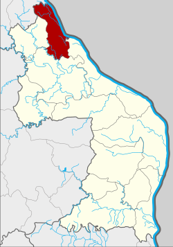
Ban Phaeng district
|
Ban Phaeng บ้านแพง |
|
|---|---|
| Province: | Nakhon Phanom |
| Surface: | 284.7 km² |
| Residents: | 35,064 (2013) |
| Population density : | 118.7 U / km² |
| ZIP : | 48140 |
| Geocode : | 4804 |
| map | |

|
|
Amphoe Ban Phaeng ( Thai : อำเภอ บ้านแพง ) is a district ( Amphoe - administrative district) in the north of the province of Nakhon Phanom . The province of Nakhon Phanom is located in the northeast region of Thailand , the so-called Isan .
geography
Neighboring districts (clockwise from southeast): Amphoe Tha Uthen , Si Songkhram and Na Thom in Nakhon Phanom Province and Amphoe Bueng Khong Long in Nong Khai Province . To the east on the other bank of the Mekong is the province of Khammuan in Laos .
history
The area of today's district originally belonged to the Principality ( Mueang ) Chaiburi, today part of the Amphoe Tha Uthen .
Ban Phaeng was initially set up as a “branch circle” ( King Amphoe ) in 1948 , when it was separated from Tha Uthen. In 1952, Ban Phaeng was promoted to Amphoe.
In 1956, the Sanitary District (Sukhaphiban - สุขาภิบาล ) Ban Phaeng was established, which was upgraded to a small town ( Thesaban Tambon ) in 1999 .
administration
Provincial Administration
Ban Phaeng County is divided into six tambon ("subdistricts" or "parishes"), which are further subdivided into 75 muban ("villages").
| No. | Surname | Thai | Muban | Pop. |
|---|---|---|---|---|
| 1. | Ban Phaeng | บ้านแพง | - | 9,289 |
| 2. | Phai Lom | ไผ่ ล้อม | 8th | 3,301 |
| 3. | Phon Thong | โพนทอง | - | 5,473 |
| 4th | Nong Waeng | หนอง แวง | 17th | 9,519 |
| 8th. | Well ngua | นา งัว | 11 | 5,245 |
| 9. | Well khe | นา เข | 6th | 2,237 |
Note: Some of the Muban's data are not yet available.
Local administration
There is one municipality with "small town" status ( Thesaban Tambon ) in the district:
- Ban Phaeng (Thai: เทศบาล ตำบล บ้านแพง ) consists of parts of the Tambon Ban Phaeng.
There are also five " Tambon Administrative Organizations " ( องค์การ บริหาร ส่วน ตำบล - Tambon Administrative Organizations, TAO):
- Phai Lom (Thai: องค์การ บริหาร ส่วน ตำบล ไผ่ ล้อม )
- Phon Thong (Thai: องค์การ บริหาร ส่วน ตำบล โพนทอง )
- Nong Waeng (Thai: องค์การ บริหาร ส่วน ตำบล หนอง แวง )
- Na Ngua (Thai: องค์การ บริหาร ส่วน ตำบล นา งัว )
- Na Khe (Thai: องค์การ บริหาร ส่วน ตำบล นา เข )
Individual evidence
- ↑ ประกาศ กระทรวง มหาดไทย เรื่อง ยก ฐานะ ตำบล ขึ้น เป็น กิ่ง อำเภอ . In: Royal Gazette . 64, No. 60 ง , December 9, 1947, pp. 3188-3193.
- ↑ พระราชกฤษฎีกา จัดตั้ง อำเภอ นาทวี อำเภอ สะบ้าย้อย อำเภอ คำชะอี อำเภอ ย่านตาขาว อำเภอ วัดโบสถ์ อำเภอ หนองบัว อำเภอ วัฒนานคร อำเภอ แสวงหา อำเภอ ท่าชนะ อำเภอ พระพุทธบาท อำเภอ โนนสัง อำเภอ อำเภอ บำเหน็จณรงค์ อำเภอ คอนสวรรค์ อำเภอ บ้านโฮ่ง บ้านโฮ่ง อำเภอ คีรีมาศ อำเภอ ชนแดน อำเภอ แม่แจ่ม อำเภอ ไทรน้อย และ อำเภอ บ้านแพง พ.ศ. ๒๔๙๙ . In: Royal Gazette . 73, No. 46 ก , June 5, 1956, p. 657.
- ↑ ประกาศ กระทรวง มหาดไทย เรื่อง จัดตั้ง สุขาภิบาล บ้านแพง อำเภอ บ้านแพง จังหวัด นครพนม . In: Royal Gazette . 73, No. 99 ง ฉบับ พิเศษ (special), November 28, 1956, pp. 21-22.
- ↑ 2013 population statistics ( Thai ) Department of Provincial Administration. Retrieved July 31, 2014.
Web links
Coordinates: 17 ° 58 ' N , 104 ° 13' E
