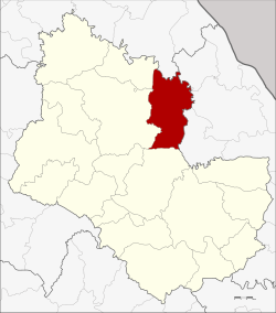
Akat Amnuai district
|
Akat Amnuai อำเภอ อากาศอำนวย |
|
|---|---|
| Province: | Sakon Nakhon |
| Surface: | 585.0 km² |
| Residents: | 70,085 (2013) |
| Population density : | 115.1 U / km² |
| ZIP : | 47170 |
| Geocode : | 4711 |
| map | |

|
|
Amphoe Akat Amnuai ( Thai : อำเภอ อากาศอำนวย ) is a district ( Amphoe - administrative district) in the province of Sakon Nakhon . The province of Sakon Nakhon is located in the northeast region of Thailand , the so-called Isan .
geography
Neighboring districts (clockwise from north): Amphoe Seka in Nong Khai Province , Amphoe Na Thom , Si Songkhram and Na Wa in Nakhon Phanom Province, and Amphoe Phanna Nikhom , Wanon Niwat and Kham Ta Kla in Sakon Nakhon Province.
history
Akat Amnuai was founded on May 15, 1963 as a "branch circle" ( King Amphoe ) by separating the four tambon Akat, Wa Yai, Phon Phaeng and Phon Ngam from the Wanon Niwat district . Akat Amnuai was promoted to Amphoe on July 27, 1965.
Administrative units
Provincial Administration
Akat Amnuai County is divided into eight tambon ("subdistricts" or "parishes"), which are further subdivided into 94 muban ("villages").
| No. | Surname | Thai | Muban | Pop. |
|---|---|---|---|---|
| 1. | Akat | อากาศ | 19th | 16,762 |
| 2. | Phon Phaeng | โพน แพง | 12 | 9,363 |
| 3. | Wa Yai | วา ใหญ่ | 14th | 9.211 |
| 4th | Phon Ngam | โพน งาม | 13 | 8,467 |
| 5. | Tha Kon | ท่า ก้อน | 8th | 5,776 |
| 6th | Hi there | นา ฮี | 9 | 5,166 |
| 7th | Ba Wa | บะ หว้า | 9 | 6,541 |
| 8th. | Samakkhi Phatthana | สามัคคี พัฒนา | 10 | 8,799 |
Local administration
There are six municipalities with "small town" status ( Thesaban Tambon ) in the district:
- Phon Phaeng (Thai: เทศบาล ตำบล โพน แพง ) consists of the entire Tambon Phon Phaeng.
- Wa Yai (Thai: เทศบาล ตำบล วา ใหญ่ ) consists of the entire tambon Wa Yai.
- Tha Kon (Thai: เทศบาล ตำบล ท่า ก้อน ) consists of the entire Tambon Tha Kon.
- Ba Wa (Thai: เทศบาล ตำบล บะ หว้า ) consists of the entire tambon Ba Wa.
- Akat Amnuai (Thai: เทศบาล ตำบล อากาศอำนวย ) consists of parts of the Tambon Akat.
- Samakkhi Phatthana (Thai: เทศบาล ตำบล สามัคคี พัฒนา ) consists of the entire Tambon Samakkhi Phatthana.
There are also three " Tambon Administrative Organizations " ( องค์การ บริหาร ส่วน ตำบล - Tambon Administrative Organizations, TAO):
- Akat (Thai: องค์การ บริหาร ส่วน ตำบล อากาศ )
- Phon Ngam (Thai: องค์การ บริหาร ส่วน ตำบล โพน งาม )
- Na Hi (Thai: องค์การ บริหาร ส่วน ตำบล นา ฮี )
Individual evidence
- ↑ ประกาศ กระทรวง มหาดไทย เรื่อง แบ่ง ท้องที่ การ ปกครอง อำเภอ นร นิวาส ตั้ง เป็น กิ่ง อำเภอ . In: Royal Gazette . 80, No. 44 ง , May 14, 1963, p. 1373.
- ↑ พระราชกฤษฎีกา ตั้ง อำเภอ ศรีสวัสดิ์ อำเภอ สังขละบุรี อำเภอ ท่าคันโท อำเภอ ดอกคำใต้ อำเภอ แม่ใจ อำเภอ จุน อำเภอ ขามทะเลสอ อำเภอ ไพศาลี อำเภอ ท่าวังผา อำเภอ บ้านกรวด อำเภอ เด่นชัย เด่นชัย อำเภอ ปทุม รัตน์ อำเภอ กะเปอร์ อำเภอ อำเภอ อากาศอำนวย อำเภอ ดอนเจดีย์ อำเภอ จอมพระ และ อำเภอ สามโก้ พ.ศ. ๒๕๐๘ . In: Royal Gazette . 81, No. 49 ก , July 27, 1965, pp. 565-569.
- ↑ 2013 population statistics ( Thai ) Department of Provincial Administration. Retrieved August 3, 2014.
Web links
Coordinates: 17 ° 35 ' N , 103 ° 59' E
