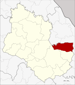
Amphoe Kusuman
|
Kusuman กุสุมาลย์ |
|
|---|---|
| Province: | Sakon Nakhon |
| Surface: | 454.0 km² |
| Residents: | 46,598 (2013) |
| Population density : | 99.1 U / km² |
| ZIP : | 47210, 47230 |
| Geocode : | 4702 |
| map | |

|
|
Amphoe Kusuman ( Thai : อำเภอ กุสุมาลย์ ) is a district ( Amphoe - administrative district) in the southeast of the province of Sakon Nakhon . The province of Sakon Nakhon is located in the northeast region of Thailand , the so-called Isan .
geography
Amphoe Kusuman is bordered clockwise from the south by Phon Na Kaeo and Mueang Sakon Nakhon in Sakon Nakhon Province and Na Wa , Phon Sawan , Mueang Nakhon Phanom and Pla Pak in Nakhon Phanom Province .
history
Amphoe Kusuman goes back to Mueang Kusuman, which was established in 1844. A second mueang called Phot Phaisan was created nearby in 1862. In 1914, Kusuman was demoted to a tambon (municipality) in Sakon Nakhon Province. Kusuman was made a King Amphoe ("Branch Circle") again in 1962 after the size of the Mueang made it difficult to manage. On November 14, 1967, Kusuman became a full amphoe again.
administration
Provincial Administration
The county of Kusuman is divided into five tambon ("subdistricts" or "parishes"), which are further subdivided into 69 muban ("villages").
| No. | Surname | Thai | Muban | Pop. |
|---|---|---|---|---|
| 1. | Kusuman | กุสุมาลย์ | 13 | 10,927 |
| 2. | Well Pho | นา โพธิ์ | 12 | 7,997 |
| 3. | Well Phiang | นา เพียง | 11 | 7,657 |
| 4th | Pho Phaisan | โพธิ ไพศาล | 16 | 10,001 |
| 5. | To Chan | อุ่ ม จาน | 17th | 10,016 |
Local administration
There is one municipality with "small town" status ( Thesaban Tambon ) in the district:
- Kusuman (Thai: เทศบาล ตำบล กุสุมาลย์ ), consisting of parts of the Tambon Kusuman.
There are also five " Tambon Administrative Organizations " ( องค์การ บริหาร ส่วน ตำบล - Tambon Administrative Organizations, TAO):
- Kusuman (Thai: องค์การ บริหาร ส่วน ตำบล กุสุมาลย์ )
- Na Pho (Thai: องค์การ บริหาร ส่วน ตำบล นา โพธิ์ )
- Na Phiang (Thai: องค์การ บริหาร ส่วน ตำบล นา เพียง )
- Pho Phaisan (Thai: องค์การ บริหาร ส่วน ตำบล โพธิ ไพศาล )
- Um Chan (Thai: องค์การ บริหาร ส่วน ตำบล อุ่ ม จาน )
Individual evidence
- ↑ ประกาศ กระทรวง มหาดไทย เรื่อง แบ่ง ท้องที่ การ ปกครอง อำเภอ เมือง สกลนคร ตั้ง เป็น กิ่ง อำเภอ . In: Royal Gazette . 81, No. 14 ง , February 4, 1964, p. 250.
- ↑ พระราชกฤษฎีกา เปลี่ยนแปลง เขต อำเภอ กุดบาก และ อำเภอ กุสุมาลย์ พ.ศ. ๒๕๑๐ . In: Royal Gazette . 84, No. 111 ก , November 14, 1967, pp. 917-919.
- ↑ 2013 population statistics ( Thai ) Department of Provincial Administration. Retrieved August 3, 2014.
Web links
Coordinates: 17 ° 20 ′ N , 104 ° 20 ′ E
