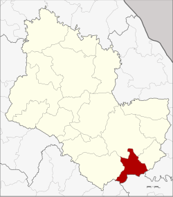
Tao Ngoi district
|
Tao Ngoi เต่า ง อย |
|
|---|---|
| Province: | Sakon Nakhon |
| Surface: | 328 km² |
| Residents: | 23,831 (2013) |
| Population density : | 159 U / km² |
| ZIP : | 47260 |
| Geocode : | 4714 |
| map | |

|
|
Amphoe Tao Ngoi ( Thai อำเภอ เต่า ง อย ) is a district ( Amphoe - Administrative District) of the Province of Sakon Nakhon . The province of Sakon Nakhon is located in the northeast region of Thailand , the so-called Isan .
geography
Amphoe Tao Ngoi is located in the south of the province of Sakon Nakhon and, viewed from the west, borders in a clockwise direction with the Amphoe Phu Phan , Mueang Sakon Nakhon and Khok Si Suphan in the Province of Sakon Nakhon, on Amphoe Na Kae in the Province of Nakhon Phanom , on Amphoe Dong Luang der Mukdahan Province , as well as at Amphoe Na Khu of Kalasin Province .
history
Amphoe Tao Ngoi was established on September 1, 1978 as a "branch circle" ( King Amphoe ) by spinning off the two tambon Tao Ngoi and Bueng Thawai from the Amphoe Mueang Sakon Nakhon . It was upgraded to a full amphoe on July 19, 1991.
administration
Provincial Administration
Tao Ngoi County is divided into four tambon ("subdistricts" or "parishes"), which are further subdivided into 32 muban ("villages").
| No. | Surname | Thai | Muban | Pop. |
|---|---|---|---|---|
| 1. | Tao Ngoi | เต่า ง อย | 7th | 5,705 |
| 2. | Bueng Thawai | บึง ทวาย | 10 | 5,405 |
| 3. | Well tan | นา ตาล | 7th | 5,522 |
| 4th | Chan Phen | จันทร์ เพ็ญ | 8th | 7.199 |
Local administration
There are four " Tambon Administrative Organizations " ( องค์การ บริหาร ส่วน ตำบล - Tambon Administrative Organizations, TAO) in the district:
- Tao Ngoi (Thai: องค์การ บริหาร ส่วน ตำบล เต่า ง อย )
- Bueng Thawai (Thai: องค์การ บริหาร ส่วน ตำบล บึง ทวาย )
- Na Tan (Thai: องค์การ บริหาร ส่วน ตำบล นา ตาล )
- Chan Phen (Thai: องค์การ บริหาร ส่วน ตำบล จันทร์ เพ็ญ )
Individual evidence
- ↑ ประกาศ กระทรวง มหาดไทย เรื่อง แบ่ง ท้องที่ อำเภอ เมือง สกลนคร จังหวัด สกลนคร ตั้ง เป็น กิ่ง อำเภอ ต่าง อย . In: Royal Gazette . 95, No. 89 ง , August 29, 1978, p. 2829.
- ↑ พระราชกฤษฎีกา ตั้ง อำเภอ ทุ่งตะโก อำเภอ พะโต๊ะ อำเภอ เขา ค้อ อำเภอ น้ำ หนาว อำเภอ วัง จันทร์ อำเภอ นาด้วง อำเภอ เต่า ง อย อำเภอ สิงห สิงห นคร อำเภอ พระ สมุทร เจดีย์ และ อำเภอ ลำดวน พ.ศ. ๒๕๓๔ . In: Royal Gazette . 108, No. 107 ก ฉบับ พิเศษ (special), June 19, 1991, pp. 29-33.
- ↑ 2013 population statistics ( Thai ) Department of Provincial Administration. Retrieved August 3, 2014.
Web links
Coordinates: 17 ° 0 ′ N , 104 ° 10 ′ E
