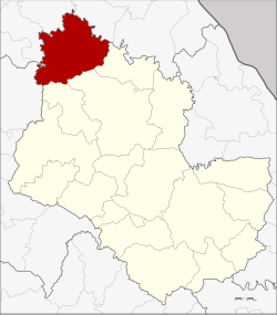
Ban Muang district
|
Ban Muang บ้านม่วง |
|
|---|---|
| Province: | Sakon Nakhon |
| Surface: | 850 km² |
| Residents: | 69,907 (2013) |
| Population density : | 79 U / km² |
| ZIP : | 47140 |
| Geocode : | 4710 |
| map | |

|
|
Ban Muang District ( Thai อำเภอ บ้านม่วง ) is a district ( Amphoe - administrative district) of the province of Sakon Nakhon . The province of Sakon Nakhon is located in the northeast region of Thailand , the so-called Isan .
geography
Amphoe Ban Muang is located in the north of the province of Sakon Nakhon and, viewed from the west, borders in a clockwise direction on Amphoe Ban Dung in the province of Udon Thani , on the Amphoe Fao Rai , So Phisai and Phon Charoen in the province of Nong Khai , and on the Amphoe Kham Ta Kla , Wanon Niwat and Charoen Sin in Sakon Nakhon Province.
history
Amphoe Ban Muang was created as a "branch circle" ( King Amphoe ) on March 20, 1968 , when the three Tambon Mai, Muang and Dong Mo Thong were spun off from Amphoe Wanon Niwat . On November 16, 1971, it was upgraded to a full Amphoe.
administration
Provincial Administration
Ban Muang County is divided into nine tambon ("subdistricts" or "parishes"), which are further subdivided into 98 muban ("villages").
| No. | Surname | Thai | Muban | Pop. |
|---|---|---|---|---|
| 1. | Muang | ม่วง | 11 | 8,615 |
| 2. | May | มา ย | 10 | 6,169 |
| 3. | Dong Mo Thong | ดง หม้อ ทอง | 11 | 7,331 |
| 4th | Dong Nuea | ดง เหนือ | 12 | 7,267 |
| 5. | Dong Mo Thong Tai | ดง หม้อ ทอง ใต้ | 10 | 8,458 |
| 6th | Huai Lua | ห้วย หลัว | 9 | 7,522 |
| 7th | Non Sa-at | โนนสะอาด | 10 | 5,597 |
| 8th. | Nong Kwang | หนอง ก วั่ ง | 11 | 9,415 |
| 9. | Bo Kaeo | บ่อ แก้ว | 14th | 9,533 |
Local administration
There are two municipalities with "small town" status ( Thesaban Tambon ) in the district:
- Huai Lua (Thai: เทศบาล ตำบล ห้วย หลัว ), consisting of the entire tambon Huai Lua.
- Ban Muang (Thai: เทศบาล ตำบล บ้านม่วง ), consisting of parts of the Tambon Muang.
There are also eight " Tambon Administrative Organizations " ( องค์การ บริหาร ส่วน ตำบล - Tambon Administrative Organizations, TAO):
- Muang (Thai: องค์การ บริหาร ส่วน ตำบล ม่วง )
- Mai (Thai: องค์การ บริหาร ส่วน ตำบล มา ย )
- Dong Mo Thong (Thai: องค์การ บริหาร ส่วน ตำบล ดง หม้อ ทอง )
- Dong Nuea (Thai: องค์การ บริหาร ส่วน ตำบล ดง เหนือ )
- Dong Mo Thong Tai (Thai: องค์การ บริหาร ส่วน ตำบล ดง หม้อ ทอง ใต้ )
- Non Sa-at (Thai: องค์การ บริหาร ส่วน ตำบล โนนสะอาด )
- Nong Kwang (Thai: องค์การ บริหาร ส่วน ตำบล หนอง ก วั่ ง )
- Bo Kaeo (Thai: องค์การ บริหาร ส่วน ตำบล บ่อ แก้ว )
Individual evidence
- ↑ ประกาศ กระทรวง มหาดไทย เรื่อง แบ่ง ท้องที่ ตั้ง เป็น กิ่ง อำเภอ . In: Royal Gazette . 85, No. 25 ง , March 19, 1968, p. 836.
- ↑ พระราชกฤษฎีกา ตั้ง อำเภอ ปลาปาก อำเภอ เชียงกลาง อำเภอ ปากชม อำเภอ บ้านม่วง อำเภอ พังโคน อำเภอ ดอนสัก อำเภอ พนม อำเภอ เวียงสระ อำเภอ สังคม และ อำเภอ หัวตะพาน พ.ศ. ๒๕๑๔ . In: Royal Gazette . 88, No. 123 ก , November 16, 1971, pp. 745-748.
- ↑ 2013 population statistics ( Thai ) Department of Provincial Administration. Retrieved August 3, 2014.
Web links
Coordinates: 17 ° 51 ' N , 103 ° 34' E
