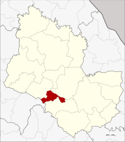
Amphoe Nikhom Nam Un
|
Nikhom Nam Un นิคมน้ำอูน |
|
|---|---|
| Province: | Sakon Nakhon |
| Surface: | 162 km² |
| Residents: | 14,641 (2013) |
| Population density : | 85 U / km² |
| ZIP : | 47270 |
| Geocode : | 4707 |
| map | |

|
|
Amphoe Nikhom Nam Un ( Thai อำเภอ นิคมน้ำอูน ) is a district ( amphoe - administrative district) in the southwest of the province of Sakon Nakhon . The province of Sakon Nakhon is located in the northeast region of Thailand , the so-called Isan .
geography
The Amphoe Nikhom Nam Un is bordered clockwise from the north by the Amphoe Waritchaphum , Phanna Nikhom and Kut Bak in the province of Sakon Nakhon and by Amphoe Wang Sam Mo in the province of Udon Thani
The main source of water in the Amphoe is the Nam-Un Dam.
history
Nikhom Nam Un was formed on June 16, 1975 initially as a “branch circle” ( King Amphoe ) through the separation of the Tambon Nikhom Nam Un and Nong Pling from the Waritchaphum district. On July 4, 1994, it was finally upgraded to a full Amphoe.
In 1969, the Nam-Un dam was built north of today's Nikhom Nam Un in Phang Khon district . The people whose land was flooded at that time settled in Nikhom Nam Un.
administration
Provincial Administration
Nikhom Nam Un County is divided into four tambon ("subdistricts" or "parishes"), which are further subdivided into 29 muban ("villages").
| No. | Surname | Thai | Muban | Pop. |
|---|---|---|---|---|
| 1. | Nikhom Nam Un | นิคมน้ำอูน | 10 | 5,159 |
| 2. | Nong Pling | หนอง ปลิง | 8th | 3,691 |
| 3. | Nong Bua | หนองบัว | 4th | 1,778 |
| 4th | Suwannakham | สุวรรณ คาม | 7th | 4.013 |
Local administration
There are also four " Tambon Administrative Organizations " ( องค์การ บริหาร ส่วน ตำบล - Tambon Administrative Organizations, TAO):
- Nikhom Nam Un (Thai: องค์การ บริหาร ส่วน ตำบล นิคมน้ำอูน )
- Nong Pling (Thai: องค์การ บริหาร ส่วน ตำบล หนอง ปลิง )
- Nong Bua (Thai: องค์การ บริหาร ส่วน ตำบล หนองบัว )
- Suwannakham (Thai: องค์การ บริหาร ส่วน ตำบล สุวรรณ คาม )
Individual evidence
- ↑ ประกาศ กระทรวง มหาดไทย เรื่อง แบ่ง ท้องที่ อำเภอ วาริชภูมิ จังหวัด สกลนคร ตั้ง เป็น กิ่ง อำเภอ นิคมน้ำอูน . In: Royal Gazette . 92, No. 112 ง , June 17, 1975, p. 1477.
- ↑ พระราชกฤษฎีกา ตั้ง อำเภอ เปือยน้อย ... และ อำเภอ ศรีวิไล พ.ศ. ๒๕๓๗ . In: Royal Gazette . 111, No. 21 ก , June 3, 1994, pp. 32-35.
- ↑ 2013 population statistics ( Thai ) Department of Provincial Administration. Retrieved August 3, 2014.
Web links
- Further information on the Amphoe Amphoe Nikhom Nam Un (in Thai language)
Coordinates: 17 ° 11 ' N , 103 ° 43' E
