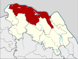
Amphoe Mueang Bueng Kan
|
Mueang Bueng Kan เมือง บึงกาฬ |
|
|---|---|
| Province: | Bueng Kan |
| Surface: | 791.9 km² |
| Residents: | 90,971 (2013) |
| Population density : | 105.5 U / km² |
| ZIP : | 38000 |
| Geocode : | 3801 |
| map | |

|
|
Amphoe Mueang Bueng Kan ( Thai : อำเภอ เมือง บึงกาฬ ) is a district ( amphoe - administrative district) in the province of Bueng Kan . The province of Bueng Kan is located in the north of the northeast region of Thailand , the so-called Isan .
geography
The province of Bueng Kan is located about 615 kilometers northeast of Bangkok along the Mekong , which is the border with Laos .
Bueng Kan district borders the following counties (clockwise from the east): Bung Khla , Seka , Si Wilai , Phon Charoen , So Phisai and Pak Khat district in Bueng Kan Province. To the north on the other bank of the Mekong lies the Bolikhamsai province of Laos .
history
The district was originally called Chaiburi ( ไชย บุรี ), it was part of the Nakhon Phanom Province . In 1917 it was subordinated to Nong Khai Province, and in 1939 it was renamed Bueng Kan.
On August 3, 2010, the proposal to separate Bueng Kan Province from Nong Khai Province was approved by the Thai government. On March 22, 2011, the Act Establishing Changwat Bueng Kan, BE 2554 (2011) was published in the Royal Thai Government Gazette. The district of Bueng Kan became the eponymous district (Amphoe Mueang) of the new province and therefore according to Section 4 of the Act renamed Amphoe Mueang Bueng Kan .
administration
Provincial Administration
Mueang Bueng Kan County is divided into twelve tambon ("subdistricts" or "parishes"), which are further subdivided into 131 muban ("villages").
| No. | Surname | Thai | Muban | Pop. |
|---|---|---|---|---|
| 1. | Bueng Kan | บึงกาฬ | 11 | 10.116 |
| 2. | Non sombun | โนน สมบูรณ์ | 13 | 10,019 |
| 3. | Non Sawang | โนน สว่าง | 11 | 6,814 |
| 4th | Ho Kham | หอคำ | 14th | 7.210 |
| 5. | Nong Loeng | หนอง เลิ ง | 13 | 8,599 |
| 6th | Khok Kong | โคก ก่อง | 9 | 6,938 |
| 7th | Well Sawan | นา สวรรค์ | 9 | 7,648 |
| 8th. | Khai Si | ไค สี | 10 | 5,378 |
| 9. | Chaiyaphone | ชัย พร | 13 | 8,318 |
| 10. | Wisit | วิ ศิ ษ ฐ์ | 13 | 9,675 |
| 11. | Kham Na Di | คำ นาดี | 8th | 5,164 |
| 12. | Pong Pueai | โป่ง เปื อย | 7th | 5,092 |
Note: The missing numbers (geocodes) refer to the tambon , which today belong to Bung Khla and Si Wilai.
Local administration
There are seven municipalities with "small town" status ( Thesaban Tambon ) in the district:
- Nong Loeng (Thai: เทศบาล ตำบล หนอง เลิ ง ), consisting of the entire Tambon Nong Loeng.
- Khok Kong (Thai: เทศบาล ตำบล โคก ก่อง ), consisting of the entire tambon Khok Kong.
- Khai Si (Thai: เทศบาล ตำบล ไค สี ), consisting of the entire tambon Khai Si.
- Bueng Kan (Thai: เทศบาล ตำบล บึงกาฬ ), consisting of parts of the Tambon Bueng Kan and Wisit.
- Wisit (Thai: เทศบาล ตำบล วิ ศิ ษ ฐ์ ), consisting of the remaining parts of the tambon Wisit.
- Non Sawang (Thai: เทศบาล ตำบล โนน สว่าง ), consisting of the entire tambon Non Sawang.
- Ho Kham (Thai: เทศบาล ตำบล หอคำ ), consisting of the entire tambon Ho Kham.
There are also six " Tambon Administrative Organizations " ( องค์การ บริหาร ส่วน ตำบล - Tambon Administrative Organizations, TAO):
- Bueng Kan (Thai: องค์การ บริหาร ส่วน ตำบล บึงกาฬ )
- Non Sombun (Thai: องค์การ บริหาร ส่วน ตำบล โนน สมบูรณ์ )
- Na Sawan (Thai: องค์การ บริหาร ส่วน ตำบล นา สวรรค์ )
- Chaiyaphon (Thai: องค์การ บริหาร ส่วน ตำบล ชัย พร )
- Kham Na Di (Thai: องค์การ บริหาร ส่วน ตำบล คำ นาดี )
- Pong Pueai (Thai: องค์การ บริหาร ส่วน ตำบล โป่ง เปื อย )
Individual evidence
- ↑ พระราชกฤษฎีกา เปลี่ยน นาม อำเภอ กิ่ง อำเภอ และ ตำบล บาง แห่ง พุทธศักราช ๒๔๘๒ . In: Royal Gazette . 56, No. 0 ก , April 17, 1939, pp. 354-364.
- ^ Govt denies being superstitious in adding the 77th province , National News Bureau of Thailand, Public Relations Department. August 4, 2010. Archived from the original on July 20, 2011.
- ↑ พระราชบัญญัติ ตั้ง จังหวัด บึงกาฬ พ.ศ. ๒๕๕๔ . In: Royal Gazette . 128, No. 18 ก , March 22, 2011, pp. 1–5.
- ↑ 2013 population statistics ( Thai ) Department of Provincial Administration. Retrieved August 4, 2014.
Web links
Coordinates: 18 ° 21 ' N , 103 ° 39' E