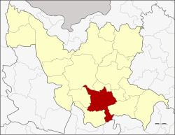
Amphoe Kumphawapi
|
Kumphawapi กุมภวาปี |
|
|---|---|
| Province: | Udon Thani |
| Surface: | 672.6 km² |
| Residents: | 125,036 (2012) |
| Population density : | 187.6 U / km² |
| ZIP : | 41110, 41370 |
| Geocode : | 4104 |
| map | |

|
|
Amphoe Kumphawapi ( Thai อำเภอ กุมภวาปี ) is a district ( Amphoe - administrative district) in the south of Udon Thani Province . The Udon Thani Province is located in the northwestern part of Isan , the northeast region of Thailand .
etymology
กุมภา - Kumpha comes from Sanskrit (kumbha) and means water jug or the zodiac sign Aquarius . วาปี - Wapi comes from Sanskrit vapi , which means pond .
geography
Adjacent areas (from the southwest clockwise) the Amphoe Non Sa-at , Nong Saeng , Mueang Udon Thani , Prachaksinlapakhom , Ku Kaeo and Si That in the province of Udon Thani, Amphoe Tha Khantho the province Kalasin and Amphoe Kranuan the province Khon Kaen .
A major attraction in the district is Lake Nong Han (Kumphawapi) or, more popularly, Thale Bua Daeng ("Lake of the Red Lotus"), which is covered with thousands of pink water lilies from October to March .
history
There is a prehistoric excavation site in Ban Mueang Phruek .
Mueang Kumphawapi was one of the four original districts of Udon Thani that were made into amphoe in the 1908 thesaphiban administrative reform.
traffic
Kumphawapi has a train station on the northeast line of the Thai Railway ( Nakhon Ratchasima – Nong Khai line ). The Thanon Mittraphap ("Street of Friendship"; National Road 2) runs through the district .
administration
Provincial Administration
Amphoe Kumphawapi is divided into 13 communities ( Tambon ) , which in turn are divided into 175 villages ( Muban ) .
| No. | Surname | Thai | Villages | Pop. |
|---|---|---|---|---|
| 1. | Tum Tai | ตูม ใต้ | 9 | 7,059 |
| 2. | Phan Don | พัน ดอน | 20th | 17,628 |
| 3. | Wiang Kham | เวียง คำ | 18th | 10,365 |
| 4th | Chaelae | แช แล | 14th | 10,442 |
| 6th | Chiang Wae | เชียง แหว | 13 | 8,746 |
| 7th | Huai Koeng | ห้วย เกิ้ง | 8th | 5,592 |
| 9. | Soephloe | เส อ เพล อ | 19th | 11,997 |
| 10. | Si O | สี ออ | 8th | 4,522 |
| 11. | Pakho | ปะ โค | 17th | 11,355 |
| 13. | Pha Suk | ผาสุก | 10 | 6,483 |
| 14th | Tha Li | ท่าลี่ | 13 | 9,628 |
| 15th | Kumphawapi | กุมภวาปี | 14th | 13,374 |
| 16. | Nong Wa | หนอง หว้า | 11 | 7,845 |
Note: The missing codes belong to the tambon that today Amphoe Prachaksinlapakhom consists of.
Local administration
There are nine small towns ( Thesaban Tambon ) in the county:
- Kumphawapi ( เทศบาล ตำบล กุมภวาปี ), consisting of parts of the Tambon Kumphawapi,
- Phan Don ( เทศบาล ตำบล พัน ดอน ), consisting of parts of the Tambon Phan Don,
- Huai Koeng ( เทศบาล ตำบล ห้วย เกิ้ง ), consisting of the entire tambon Huai Koeng,
- Pakho ( เทศบาล ตำบล ปะ โค ), consisting of the entire Tambon Pakho,
- Kong Phan Phan Don ( เทศบาล ตำบล ก ง พาน พัน ดอน ), consisting of the other parts of the Tambon Phan Don,
- Wiang Kham ( เทศบาล ตำบล เวียง คำ ), consisting of the entire tambon Wiang Kham,
- Chiang Wae ( เทศบาล ตำบล เชียง แหว ), consisting of the entire tambon Chiang Waem,
- Nong Wa ( เทศบาล ตำบล หนอง หว้า ), consisting of the entire tambon Nong Wa,
- Chaelae ( เทศบาล ตำบล แช แล ), consisting of the entire Tambon Chaelae.
There are also six "Tambon Administrative Organizations" (TAO, องค์การ บริหาร ส่วน ตำบล - administrative organizations) for the tambon in the district that do not belong to any city.
Individual evidence
- ↑ Dictionary ( Memento of the original from March 3, 2009 in the Internet Archive ) Info: The archive link was inserted automatically and has not yet been checked. Please check the original and archive link according to the instructions and then remove this notice. of the Royal Institute of Thailand (1982)
- ↑ แจ้ง ความ กระทรวง มหาดไทย เรื่อง ให้ รวม เมือง ก มุทธา ไส ๑ เมือง กุมภวาปี ๑ เมือง หนอง หาย ๑ อำเภอ บ้าน หมากแข้ง ๑ ตั้ง เป็น เมือง จัตวา จัตวา เรียก ว่า เมือง อุดรธานี บริเวณ น้ำ ชี ให้ เปลี่ยน เรียก ว่า เมือง ขอนแก่น บริเวณ น้ำ เหื อง ว่า เมือง เรียก เรียก เรียก เรียก เรียก เรียก เรียก เลย บริเวณ สกลนคร ให้ เปลี่ยน เรียก ว่า เมือง สกลนคร บริเวณ ธาตุพนม ให้ เปลี่ยน เรียก ว่า เมือง นครพนม ส่วน เมือง หนองคาย เมือง โพนพิสัย ให้ คง ไว้ ตาม เดิม . In: Royal Gazette . 24, No. 41, January 12, 1908, p. 1088.
- ↑ Population statistics 2012 . Department of Provincial Administration. Retrieved June 24, 2014.
Web links
Coordinates: 17 ° 7 ' N , 103 ° 1' E
