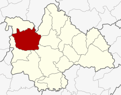
Amphoe Nong Kung Si
|
Nong Kung Si หนองกุงศรี |
|
|---|---|
| Province: | Kalasin |
| Surface: | 626.944 km² |
| Residents: | 66,595 (2013) |
| Population density : | 104.5 U / km² |
| ZIP : | 46220 |
| Geocode : | 4612 |
| map | |

|
|
Amphoe Nong Kung Si ( Thai : อำเภอ หนองกุงศรี ) is a district ( amphoe - administrative district) of Kalasin Province . The province of Kalasin is located in the northeast region of Thailand , the so-called Isan .
geography
The neighboring districts start clockwise from the northeast: the Amphoe Sam Chai , Sahatsakhan , Mueang Kalasin , Yang Talat and Huai Mek in the province of Kalasin, Amphoe Kranuan in the province of Khon Kaen , Amphoe Tha Khantho in Kalasin and Amphoe Wang Sam Mo in the Udon province Thani .
history
Nong Kung Si was initially set up on September 14, 1973 as a “branch circle” ( King Amphoe ) by separating the Tambon Nong Kung Si and Khok Khruea from the Amphoe Tha Khantho . In 1975 Tambon Nong Bua of Amphoe Sahatsakhan was also transferred to Nong Kung Si. On March 25, 1979, Nong Kung Si was promoted to Amphoe.
administration
Provincial Administration
Nong Kung Si County is divided into nine tambon ("subdistricts" or "parishes"), which are further divided into 113 muban ("villages").
| No. | Surname | Thai | Muban | Pop. |
|---|---|---|---|---|
| 1. | Nong Kung Si | หนองกุงศรี | 13 | 8,818 |
| 2. | Nong Bua | หนองบัว | 13 | 7.102 |
| 3. | Khok Khruea | โคก เครือ | 15th | 10,217 |
| 4th | Nong Suang | หนอง สรวง | 11 | 5,493 |
| 5. | Sao Lao | เสา เล้า | 14th | 5,846 |
| 6th | Nong Yai | หนองใหญ่ | 15th | 8,110 |
| 7th | Dong Mun | ดง มูล | 14th | 9,309 |
| 8th. | Lam Nong Saen | ลำ หนอง แสน | 8th | 5,645 |
| 9. | Nong Hin | หนอง หิน | 10 | 6,055 |
Local administration
There are seven municipalities with "small town" status ( Thesaban Tambon ) in the district:
- Kham Kao (Thai: เทศบาล ตำบล คำ ก้าว ) consists of parts of the Tambon Nong Kung Si.
- Nong Bua (Thai: เทศบาล ตำบล หนองบัว ) consists of the entire Tambon Nong Bua.
- Nong Suang (Thai: เทศบาล ตำบล หนอง สรวง ) consists of the entire Tambon Nong Suang.
- Nong Yai (Thai: เทศบาล ตำบล หนองใหญ่ ) consists of the entire Tambon Nong Yai.
- Dong Mun (Thai: เทศบาล ตำบล ดง มูล ) consists of parts of the tambon Dong Mun.
- Nong Kung Si (Thai: เทศบาล ตำบล หนองกุงศรี ) consists of parts of the Tambon Nong Kung Si and Lam Nong Saen.
- Nong Hin (Thai: เทศบาล ตำบล หนอง หิน ) consists of parts of the Tambon Nong Hin and other parts of the Tambon Dong Mun.
There are also three " Tambon Administrative Organizations " ( องค์การ บริหาร ส่วน ตำบล - Tambon Administrative Organizations, TAO):
- Khok Khruea (Thai: องค์การ บริหาร ส่วน ตำบล โคก เครือ )
- Sao Lao (Thai: องค์การ บริหาร ส่วน ตำบล เสา เล้า )
- Nong Hin (Thai: องค์การ บริหาร ส่วน ตำบล หนอง หิน )
Individual evidence
- ↑ ประกาศ กระทรวง มหาดไทย เรื่อง แบ่ง ท้องที่ อำเภอ ท่าคันโท จังหวัด กาฬสินธุ์ ตั้ง เป็น กิ่ง อำเภอ หนองกุงศรี . In: Royal Gazette . 90, No. 114 ง , September 11, 1973, p. 2830.
- ↑ พระราชกฤษฎีกา เปลี่ยนแปลง เขต อำเภอ สหัสขันธ์ กับ อำเภอ เมือง กาฬสินธุ์ และ กิ่ง อำเภอ หนองกุงศรี อำเภอ ท่าคันโท จังหวัด กาฬสินธุ์ พ.ศ. ๒๕๑๘ . In: Royal Gazette . 92, No. 146 ก Special ( ฉบับ พิเศษ ), August 1, 1975, pp. 1–3.
- ↑ พระราชกฤษฎีกา ตั้ง อำเภอ หนองกุงศรี อำเภอ ไทรงาม อำเภอ บ้านฝาง อำเภอ อุบลรัตน์ อำเภอ เวียงชัย อำเภอ ดอยเต่า อำเภอ นิคมคำสร้อย อำเภอ นาหว้า อำเภอ เสิงสาง อำเภอ ศรีสาคร อำเภอ บึงสามพัน อำเภอ นาดูน อำเภอ อำเภอ ค้อวัง อำเภอ โพธิ์ชัย อำเภอ อำเภอ เมืองสรวง อำเภอ ปลวกแดง อำเภอ ยางชุมน้อย อำเภอ กาบเชิง อำเภอ สุวรรณคูหา และ อำเภอ กุดข้าวปุ้น พ.ศ. ๒๕๒๒ . In: Royal Gazette . 96, No. 42 ก Special ( ฉบับ พิเศษ ), March 25, 1979, pp. 19–24.
- ↑ 2013 population statistics ( Thai ) Department of Provincial Administration. Retrieved July 28, 2014.
Web links
Coordinates: 16 ° 39 ' N , 103 ° 18' E
