
Phu Phrabat Historical Park
Phu Phrabat ( Thai : อุทยาน ประวัติศาสตร์ ภู พระบาท , English: Phu Phrabat Historical Park ) is a historical park in Thailand , it is located near the municipality of Ban Phue ( บัน ผื อ ), about 50 kilometers northwest of Udon Thani and about 50 kilometers southwest from Nong Khai in a landscape quite atypical for the region. Here rises from the otherwise of Agriculture (rice and vegetable growing and animal husbandry) embossed and consistently flat plateau of Isaan a tabular Hill, which is visible from a distance, though it rises only about 120-160 meters of altitude (the altitude above sea level is about 320-350 meters). While it rises significantly from the south, it ends in the north mainly in steep to vertically sloping rock walls and cliffs. From here you have an excellent view of the Mekong plain , and - in good weather - even as far as Laos .
On the densely forested, table-shaped hill, there are huge sandstone blocks broken and grooved by ice age erosion , bizarre rock formations, similar to those found in the Sao Chaliang Nature Park in Pha Taem in Ubon Ratchathani . But the flora is exceptionally rich here and plants such as Ormosia, Pterocarpus, Shorea and rose woods can be found here . The hill is also the headwaters of numerous streams that flow north and east of the Mekong.
Historical park
In several grottos or niches under grooved or overhanging rocks there are rock drawings that are executed in red and include people (hunters) and animals - in the so-called cave of the people ( ถ้ำ คน - Tham Khon ) and the cave of the (red) Cattle ( ถ้ำ วัว แดง - Tham Wua (Daeng) ) - represent. They are likely to date from around 5,000–6,000 BC. BC (according to other sources around 1,000–3,000 BC) and prove not only the very early settlement of the region, but also the use of the hill and its rock formations for cultic and ritual purposes. The rocks and their hollows offered the non-sedentary population shelter and spatial and transcendent orientation. Incidentally, an early Bronze Age settlement in nearby Ban Chiang has been proven for the same epoch .
Some of the rock faces were decorated with bas-reliefs of sitting and standing Buddhas in later times - in the Dvaravati and Lop Buri epochs. Presumably they served as monastic hermitages . Khmer peoples are said to have settled here from the 9th century . For Buddhist and Hindu rituals, some of the rocks were surrounded in a circle with sandstone steles , in which Buddha images are carved . Buddha statues and other lucky charms have recently been placed under several of the rocks.
The local population of modern times associated the rock formations with a regional folkloric tradition and referred to the individual objects with appropriate names. The legendary legend of Nang Usa and Thao Barot ( นาง อุสา - ท้าว บา รส ) was related to this area, and so the rocks have names such as Ho Nang Usa ( หอ นาง อุสา ), Wat Phota ( วัด พ่อตา ), Wat Luk Koei ( วัด ลูกเขย - Wat means temple ), Khok-Ma Thao Barot ( คอก ม้า ท้าว บา รส ) or Tham Ruesi ( tham means cave and ruesi hermit ; thus hermit's cave ). Of course, this assignment has nothing to do with the rock formations in reality, but it is now firmly rooted in the minds of the population. The characteristic rock with the name Hoh Nang Ussa is used as a symbol of the Udon Thani province and offered as a postcard motif as well as a miniaturized replica for souvenirs .
The legend revolves around a king (Phaya Kong Phan), his fabulously beautiful daughter (Nang Usa), a hermit (Ruesi Chantra) and the loving prince of another kingdom (Thao Barot). The prominent rock formation - a mushroom-shaped figure, under whose massive stone roof there is a small niche-like shrine - is supposed to represent the tower into which the beautiful princess was banished by her providential father.
From 1972 the archaeological sites were researched and documented. A total of 68 prehistoric structures are recorded, 45 rock carvings (of which - because of their size and easy accessibility - but only the two above mentioned are noticeable to the common visitor), and 23 sandstone steles, which have been divided into nine groups.
The Phu Phrabat Historical Park was officially established section 63 with the publication in the Royal Gazette no. 98 of 28 April 1981. It was opened to the public in 1989. A beautiful circular path leads to all the important rocks and several viewpoints. On June 26, 1992, the park was officially opened by Princess Maha Chakri Sirindhorn . In 2004, the historical park, together with the forest park established in 1996, was entered by UNESCO on the list of places designated as world cultural heritage.
Temple complexes
The extensive temple complex of Wat Phra Phutthabat Bua Bok (Thai: วัด พระพุทธบาท บัวบก ) is located in a clearing of the otherwise densely wooded hill . Here - located between the rock formations that are everywhere - one large and several small chedis as well as a prang , which - in a smaller format and also less elaborately decorated and gilded - is modeled on the important Wat Phra That Phanom in Nakhon Phanom . Because of the Buddha's footprint in the local wat , the temple is an important religious pilgrimage site in the north of Isaan. In the vicinity of this large prang, which is richly decorated, but has lost its white-gold coloration due to the weather, there is also an exact replica of Wat Phra That Phanom, almost ten meters high (see the illustration).
A little further south of this complex there is a second temple, the less important Wat Phra Phuttabat Bua Baan ( วัด พระพุทธบาท บัว บาน ).

Hoh Nang Ussa
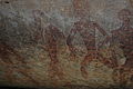
Tham Khon , rock carvings in the cave of men

Replica of That Phanom in Wat Phra Putthabat Bua Bok


literature
- Brochure of the Thai Fine Arts Department about the Phu Phrabat Historical Park , undated
- Karnjana Karnjanatawe: As weird as it gets - A park of bizarre geological formations, rock paintings, shrines and prehistoric dwellings , in: Bangkok Post , February 16, 2006.
Web links
- Report on a trip to Phu Phrabat (in English)
Coordinates: 17 ° 44 ′ 0 ″ N , 102 ° 21 ′ 30 ″ E