Yasothon (province)
| Yasothon | |
|---|---|
| ยโสธร | |
| statistics | |
| Capital: | Yasothon |
| Telephone code: | 045 |
| Surface: |
4,161.6 km² 54. |
| Residents: |
539.134 (2009) 44. |
| Population density : | 130 E / km² 31. |
| ISO 3166-2 : | |
| Governor : | Phongsak Nakprada |
| map | |
Yasothon ( Thai ยโสธร ) is a province ( Changwat ) in the northeast region of Thailand , the so-called Isan .
The "capital" of the province of Yasothon is also called Yasothon .
geography
The province of Yasothon is located about 550 kilometers northeast of the capital Bangkok on the Khorat plateau and is traversed by the Mae Nam Chi ( Thai แม่น้ำ ชี , Chi River ).
| Neighboring provinces: | |
|---|---|
| north | Mukdahan |
| east | Amnat Charoen , Ubon Ratchathani |
| south | Si Sa Ket |
| west | Roi Et |
Economy and Importance
In 2011, the province's gross provincial product was 21.160 billion Baht (approx. 520 million euros). That corresponds to 34,181 baht per capita (approx. 840 euros), only about a fifth of the national average. This makes Yasothon one of the economically weakest provinces in Thailand. In Thailand's 2002 socio-economic survey, Yasothon was one of the poorest provinces in the country, with a poverty rate of over 30%.
Data
The table below shows the share of the economic sectors in the gross provincial product in percent.
| Industry | 2006 | 2007 | 2008 |
|---|---|---|---|
| Agriculture | 20.3 | 21.9 | 20.4 |
| Industry | 8.2 | 9.7 | 11.1 |
| Other | 71.5 | 68.4 | 68.5 |
All figures in%
Land use
The following land use is documented for the province:
- Forest area: 272,727 Rai (170 km²), 10.5% of the total area
- Agricultural area: 1,872,165 Rai (1,170 km²), 72.0% of the total area
- Unclassified area: 456,148 rai (285 km²), 17.5% of the total area
The province of Yasothon has a total of 592 wetlands with an area of 50.5 km², which are used more or less intensively for agriculture .
history
Yasothon only became an independent province on March 1, 1972; before that it was part of Ubon Ratchathani Province .
Culture and sights
Attractions
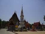
- Wat Maha That - over 1000 years old Buddhist temple complex ( Wat ) , the Chedi Phra That Yasothon (also Phra That Anon ) is said to contain a relic of Ananda (the Buddha's "favorite disciple").
- Phra That Kong Khao Noi - an old chedi that houses a Buddha statue .
- Archaeological site - prehistoric excavation site, also in Tat Thong village.
Local festivals
Soeng Bung Fai - The rocket festival takes place in mid-May, with a competition for the rocket that is shot down the highest. The festival can be traced back to animistic origins and is supposed to amuse the rain god Phraya Thaen .
Coat of arms and motto
The coat of arms of the Yasothon province shows two lions opposite the Chedi Phra A-non in the temple Wat Mahathat Yasothon . They point to the legend of the city's foundation when, at the time of choosing the right place, a lion appeared out of the forest. Then the city was named Ban Tha Singh, City of the Lion.
The local flower is the tiger lotus (Nymphaea lotus) , the local tree is Anisoptera costata .
The motto of Yasothon Province is:
- "Yasothon is the city where people believe in democracy ,
- Where sweet watermelons grow steadily.
- The Bang Fai missiles soar in the sky
- Embroidered pillows called Pha Khit
- And fragrant rice are the important things here. "
Administrative units
Provincial Administration
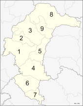
The province is divided into 9 districts ( Amphoe ) . These districts are further subdivided into 78 communes ( tambon ) and 835 villages ( muban ) .
|
Local administration
A provincial administrative organization ( บริหาร ส่วน จังหวัด , อบ จ for short , Ongkan Borihan suan Changwat ; English Provincial Administrative Organization , PAO) exists for the entire area of the province .
There is a Thesaban Mueang ( เทศบาล เมือง - "city") in the province : Yasothon ( เทศบาล เมือง ยโสธร ).
There are also nine Thesaban Tambon ( เทศบาล ตำบล - "small towns").
Individual evidence
- ↑ Gross Regional and Provincial Product, Chain Volume Measures 2011 (PDF; 1.5 MB), National Economic and Social Development Board. Archived from the original on October 5, 2013 ; accessed on November 28, 2015 .
- ↑ Somchai Jitsuchon, Kaspar Richter: Thailand's Poverty Maps. From construction to application. (PDF; 3.9 MB) In: More Than a Pretty Picture. Using Poverty Maps to Design Better Policies and Interventions. World Bank, Washington DC 2007, p. 256.
- ↑ a b Thailand in Figures (2011), p. 329.
- ↑ Edmund JV Oh, Blake D. Ratner, Simon Bush, Komathi Kolandai and Terence Y. Too (eds.): Wetlands Governance in the Mekong Region: country reports on the legal-institutional framework and economic valuation of aquatic resources . 2005.
- ↑ Department of Provincial Administration : As of 2012 (in Thai)
literature
- Thailand in Figures 2011 . Nonthaburi: Alpha Research 13 A. 2011. ISBN = 9786167526034.
Web links
- Outline map of Yasothon Province (names in English and Thai)
Coordinates: 15 ° 48 ' N , 104 ° 8' E


