Chachoengsao Province
| Chachoengsao | |
|---|---|
| ฉะเชิงเทรา | |

|
|
| statistics | |
| Capital: | Chachoengsao |
| Telephone code: | 038 |
| Surface: |
5,351.0 km² 41. |
| Residents: |
668,983 (2009) 37. |
| Population density : | 125 E / km² 37. |
| ISO 3166-2 : | |
| Governor : | |
| map | |
Chachoengsao ( Thai : ฉะเชิงเทรา , pronunciation: [ t͡ɕʰàʔ t͡ɕʰɤːŋ saw ]) is a province ( Changwat ) in eastern Thailand . It is sometimes also counted in central Thailand .
location
The province of Chachoengsao is located a little east of Bangkok . The Mae Nam Bang Pakong ( Bang Pakong River ) flows through the western part of the province and flows into the Gulf of Thailand, where the province forms a short stretch of coast.
The east of the province is characterized by a rather hilly landscape, the mean height of which is about 100 meters above sea level.
| Bordering provinces: | |
|---|---|
| north | Prachin Buri and Nakhon Nayok |
| east | Sa Kaeo |
| south | Chanthaburi and Chon Buri |
| west | Samut Prakan , Bangkok and Pathum Thani |
Important rivers
climate
The climate is tropical - monsoonal . In 2009 there were 124 rainy days with a rainfall of 1177.3 mm . In the same year, the maximum temperature was 36.4 ° C, the minimum was 15.8 ° C.
Economy and Importance
In 2011, the "Gross Provincial Product" (was GDP ) of the province 246 591 000 000 baht . The minimum wage was set at 193 baht.
Data
The table below shows the share of the economic sectors in the gross provincial product in percent.
| Industry | 2006 | 2007 | 2008 |
|---|---|---|---|
| Agriculture | 4.8 | 4.6 | 5.4 |
| Industry | 74.4 | 76.1 | 75.7 |
| Other | 20.8 | 19.3 | 18.9 |
By far the largest contributing industry to the province's economic output in 2011 was manufacturing with 164.473 billion baht. It was followed by wholesaling and retailing with 24.817 billion baht and agriculture with 17.597 billion baht.
Land consumption
Of the 5183 km² of land, 27.9% is used for agriculture, 14.5% is forest land and the rest is not classified (as of 2008).
Products
The rice cultivation is the main source of income of the province, and there are sugar , soy , shrimp and mangoes .
The products made in Chachoengsao include jewelry and everyday objects made of coconut wood and buffalo horn, dried bananas, confectionery, and wine made from longan and lychee fruits .
More and more industry is also settling here and is migrating from nearby Bangkok.
traffic
Airport
- Bangkok ( IATA code BKK): Bangkok's new airport, Suvarnabhumi International Airport , opened in autumn 2006 and is very conveniently located for the province.
history
Chachoengsao belonged to the realm of Ayutthaya from an early age . Here, the Siamese ordered General Taksin end of the sixties of the 18th century his troops to the kingdom from Burmese to liberate.
Attractions
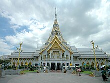
- Wat Sothon Wararam Worawihan - Buddhist temple complex ( Wat ) on the west bank of the Mae Nam Bang Pakong, about two kilometers south of the city center of Chachoengsao. It comes from the Ayutthaya period . The 84 meter high white ubosot, visible from afar, is remarkable .
- "City Pillar" ( Lak Mueang ) of Chachoengsao City - the Thai-style building contains two pillars: the older one was built in 1834 during the reign of King Rama III. (Phra Nang Klao), the younger one in 1895 during the reign of King Rama V (Chulalongkorn).
- Talat Ban Mai or Talat Rim Nam Roi Pi ( ตลาด บ้าน ใหม่ หรือ ตลาด ริม น้ำ ร้อย ปี ) - a market on Mae Nam Bang Pakong that is over a hundred years old. The community on the river still shows traditional life during the reign of King Chulalongkorn.
Symbols
The seal of the province shows the great hall of Wat Sothon Wararam Worawihan. Here is the most important Buddha statue in the province, the Phra Phutthasothon , respectfully called Luang Pho Sothon by the locals .
The local tree is the araang ( Peltophorum dasyrachis ). This symbol was assigned to the province of Queen Sirikit on the occasion of the 50th anniversary of the throne of King Bhumibol Adulyadej (Rama IX) . The local flower is that of the yellow fire flame tree ( Peltophorum pterocarpum ).
The motto of Chachoengsao Province is: "The city with a highly revered Buddha image and devout Buddhists , Located near Bangkok , easy to reach for travelers, The land of sweet mangoes and white rice , And coconut milk , sweet and pleasant."
Administrative units
Provincial Administration
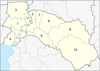
The province is divided into eleven districts ( Amphoe ) . The districts are further subdivided into 93 parishes ( tambon ) and 859 villages ( muban ).
|
Local administration
A provincial administrative organization ( บริหาร ส่วน จังหวัด , อบ จ for short , Ongkan Borihan suan Changwat ; English Provincial Administrative Organization , PAO) exists for the entire area of the province .
There is one city ( เทศบาล เมือง - Thesaban Mueang ) in the province : Chachoengsao ( เทศบาล เมือง ฉะเชิงเทรา ). There are also 25 small towns ( เทศบาล ตำบล - Thesaban Tambon ).
literature
- Thailand in Figures . 13. A. Nonthaburi: Alpha Research 2011. ISBN 978-6167-52603-4 .
Web links
- Overview map of the province (names in Thai and English) [last accessed on November 4, 2013]
Individual evidence
- ↑ Thailand in Figures, p. 283
- ^ A b Gross Provincial Product at Current Market Prices: Eastern Provinces, National Economic and Social Development Board, 2011.
- ↑ Thailand in Figures (2011)
- ↑ Department of Provincial Administration : As of 2012 (in Thai)
Coordinates: 13 ° 41 ′ N , 101 ° 4 ′ E


