Ratchasan district
|
Ratchasan ราช สาส์น |
|
|---|---|
| Province: | Chachoengsao |
| Surface: | 134.9 km² |
| Residents: | 12,855 (2013) |
| Population density : | 94.4 U / km² |
| ZIP : | 24120 |
| Geocode : | 2407 |
| map | |

|
|
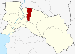
Amphoe Ratchasan ( Thai : อำเภอ ราช สาส์น ) is a district ( Amphoe - administrative district) in the center of Chachoengsao Province . The Chachoengsao Province is located in the eastern part of the central region of Thailand .
geography
Neighboring districts (clockwise from the east): Phanom Sarakham , Plaeng Yao and Bang Khla district in Chachoengsao Province and Ban Sang district in Prachin Buri Province .
An important river in the county is the Khlong Tha Lat .
history
Ratchasan was first established on February 16, 1977 as a "branch circle" ( King Amphoe ) by being separated from Phanom Sarakham district . On July 4, 1994, Ratchasan received full amphoe status.
administration
Provincial Administration
Ratchasan County is divided into three tambon ("subdistricts" or "parishes"), which are further divided into 31 muban ("villages").
| No. | Surname | Thai | Muban | Pop. |
|---|---|---|---|---|
| 1. | Bang Kha | บาง คา | 6th | 2.121 |
| 2. | Mueang May | เมือง ใหม่ | 9 | 3,195 |
| 3. | Dong Noi | ดง น้อย | 16 | 7,539 |
Local administration
In the district there are three " tambon administration organizations " ( องค์การ บริหาร ส่วน ตำบล - Tambon Administrative Organizations, TAO)
- Bang Kha (Thai: องค์การ บริหาร ส่วน ตำบล บาง คา ) consisting of the complete Tambon Bang Kha.
- Mueang Mai (Thai: องค์การ บริหาร ส่วน ตำบล เมือง ใหม่ ) consisting of the complete tambon Mueang Mai.
- Dong Noi (Thai: องค์การ บริหาร ส่วน ตำบล ดง น้อย ) consisting of the complete Tambon Dong Noi.
Individual evidence
- ↑ ประกาศ กระทรวง มหาดไทย เรื่อง แบ่ง ท้องที่ อำเภอ พนมสารคาม จังหวัด ฉะเชิงเทรา ตั้ง เป็น กิ่ง อำเภอ ราช สาส์น . In: Royal Gazette . 94, No. 13 ง , February 22 1977, p. 773.
- ↑ พระราชกฤษฎีกา ตั้ง อำเภอ เปือยน้อย ... และ อำเภอ ศรีวิไล พ.ศ. ๒๕๓๗ . In: Royal Gazette . 111, No. 21 ก , June 3 1994, pp. 32-35.
- ↑ 2013 population statistics ( Thai ) Department of Provincial Administration. Retrieved October 7, 2014.
Web links
Coordinates: 13 ° 47 ' N , 101 ° 17' E
