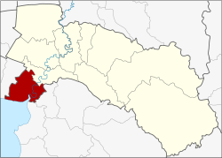
Bang Pakong district
|
Bang Pakong บางปะกง |
|
|---|---|
| Province: | Chachoengsao |
| Surface: | 257.893 km² |
| Residents: | 87,137 (2013) |
| Population density : | 302.7 U / km² |
| ZIP : | 24130, 24180 |
| Geocode : | 2404 |
| map | |

|
|
Amphoe Bang Pakong (in Thai : อำเภอ บางปะกง ) is a district ( amphoe - administrative district) in the west of the province of Chachoengsao . The Chachoengsao Province is located in the eastern part of the central region of Thailand .
geography
Neighboring districts (clockwise from north): Ban Pho district in Chachoengsao province, Phan Thong and Mueang Chonburi district in Chonburi province , the Gulf of Thailand coast and Bang Bo district in Samut Prakan province .
The main river is the Maenam Bang Pakong , which flows into the Gulf of Thailand in Bang Pakong County . In the past 10,000 years the area has been exposed to major environmental changes; the highest sea level was 4,000 years ago and since then the sea has been retreating almost continuously. The remains of a Bronze Age fishing settlement near Nong Nor and Khok Phanom Di were found here .
The Bangkok-Chonburi Motorway and the Thanon Sukhumvit (as "National Road 3") run through the district.
history
Bang Pakong was established in 1907. The first temporary administration building was initially on the site of Wat Bon Khongkharam วัด บน คงคา ราม . In 1908 the government moved the administration to the bank of Maenam Bang Pakong in Tambon Tha Sa-an. It is still there today.
administration
Provincial Administration
Bang Pakong County is divided into twelve tambon ("subdistricts" or "parishes"), which are further subdivided into 99 muban ("villages").
| No. | Surname | Thai | Muban | Pop. |
|---|---|---|---|---|
| 1. | Bang Pakong | บางปะกง | 10 | 14,732 |
| 2. | Tha Sa-an | ท่า สะอ้าน | 8th | 7,334 |
| 3. | Bang Wua | บางวัว | 14th | 12,959 |
| 4th | Bang Samak | บาง สมัคร | 9 | 13,891 |
| 5. | Bang Phueng | บาง ผึ้ง | 7th | 2,185 |
| 6th | Bang Kluea | บาง เกลือ | 7th | 4,322 |
| 7th | Song Khlong | สอง คลอง | 10 | 9,261 |
| 8th. | Nong Chok | หนองจอก | 9 | 3,649 |
| 9. | Phimpha | พิมพา | 4th | 3,339 |
| 10. | Tha Kham | ท่า ข้าม | 8th | 7,789 |
| 11. | Hom Sin | หอม ศีล | 6th | 5.102 |
| 12. | Khao Din | เขา ดิน | 7th | 2,574 |
Local administration
There are ten municipalities with "small town" status ( Thesaban Tambon ) in the district:
- Bang Pakong Phrom Thep San (Thai: เทศบาล ตำบล บางปะกง พรหม เทพ รังสรรค์ ) consisting of parts of the Tambon Bang Pakong.
- Bang Samak (Thai: เทศบาล ตำบล บาง สมัคร ) consisting of parts of the Tambon Bang Samak.
- Bang Phueng (Thai: เทศบาล ตำบล บาง ผึ้ง ) consisting of the complete Tambon Bang Phueng.
- Tha Kham (Thai: เทศบาล ตำบล ท่า ข้าม ) consisting of the complete Tambon Tha Kham.
- Tha Sa-an (Thai: เทศบาล ตำบล ท่า สะอ้าน ) consisting of parts of the tambon Tha Sa-an.
- Hom Sin (Thai: เทศบาล ตำบล หอม ศีล ) consisting of parts of the Tambon Hom Sin.
- Bang Pakong (Thai: เทศบาล ตำบล บางปะกง ) consisting of parts of the Tambon Bang Pakong.
- Bang Wua (Thai: เทศบาล ตำบล บางวัว ) consisting of the parts of the Tambon Bang Wua, Bang Samak, Bang Kluea.
- Phimpha (Thai: เทศบาล ตำบล พิมพา ) consisting of the complete tambon Phimpha.
- Bang Wua Khana Rak (Thai: เทศบาล ตำบล บางวัว ค ณา รักษ์ ) consisting of parts of the Tambon Bang Wua.
In addition, there are six " tambon administration organizations " ( องค์การ บริหาร ส่วน ตำบล - Tambon Administrative Organizations, TAO)
- Tha Sa-an (Thai: องค์การ บริหาร ส่วน ตำบล ท่า สะอ้าน ) consisting of parts of the tambon Tha Sa-an.
- Bang Kluea (Thai: องค์การ บริหาร ส่วน ตำบล บาง เกลือ ) consisting of parts of the Tambon Bang Kluea.
- Song Khlong (Thai: องค์การ บริหาร ส่วน ตำบล สอง คลอง ) consisting of the complete tambon Song Khlong.
- Nong Chok (Thai: องค์การ บริหาร ส่วน ตำบล หนองจอก ) consisting of the complete Tambon Nong Chok.
- Hom Sin (Thai: องค์การ บริหาร ส่วน ตำบล หอม ศีล ) consisting of parts of the Tambon Hom Sin.
- Khao Din (Thai: องค์การ บริหาร ส่วน ตำบล เขา ดิน ) consisting of the complete Tambon Khao Din.
Individual evidence
- ↑ 2013 population statistics ( Thai ) Department of Provincial Administration. Retrieved October 6, 2014.
Web links
Coordinates: 13 ° 33 ' N , 101 ° 0' E
