
Thanon Sukhumvit


The Thanon Sukhumvit ( Thai : ถนน สุขุมวิท , pronunciation: [ tʰanǒn-sùkʰǔmwít ], Sukhumvit Street ; in English "Sukhumvit Road") is one of the most important streets in Bangkok , the capital of Thailand , but also an important highway that is continues more than 400 km further southeast to the border with Cambodia .
Today, the Thanon Sukhumvit has partly lost its importance as a long-haul connection, as shorter connections have emerged, in particular through the Bangkok-Chonburi (Highway 7) and the Bang Na Expressway , which run parallel to Thailand Route 3.
Sukhumvit Street was named after Phra Pisan Sukhumvit, the fifth director of the Thai Department of Highways . In terms of traffic law, it is the national main road number 3 Bangkok-Trat ( ทางหลวง แผ่นดิน หมายเลข 3 กรุงเทพมหานคร - ตราด ). Thanon Sukhumvit is part of the Asian Highway AH123.
General
The Thanon Sukhumvit is one of the main business streets in the capital. In the city of Bangkok alone, it is more than ten kilometers long. It begins as a direct eastern extension of the Thanon Phloenchit, which itself leads westward over the Rama I Street (Thanon Phra Ram thi 1) and the Thanon Bamrung Mueang to the Grand Palace in the heart of the Rattanakosin Island. The Thanon Sukhumvit continues in a south-easterly and easterly direction. Its side streets ( Soi ) are numbered, with the odd numbers on the left-hand side of the street (south or west of Sukhumvit Street) and the even numbers on the opposite side of the street (north or east). It leaves the city of Bangkok at Soi 107 and runs parallel to the Thai Gulf Coast through the provinces of Samut Prakan , Chachoengsao , Chonburi (including the city of Pattaya ), Rayong (with U-Tapao Airport ) and Chanthaburi for a distance of about 400 km up to Trat to the Cambodian border.
The Thanon Sukhumvit is one of the four "Royal Roads" that connect the major regions of Thailand. The others are Thanon Phahonyothin (National Road No. 1) in the north, Thanon Mittraphap (No. 2) in the northeast, and Thanon Phetkasem (No. 4) in the south.
Transport links
The Sukhumvit area in Bangkok is very easily accessible by the Bangkok Skytrain . Most of the Sukhumvit line of the Skytrain runs along Sukhumvit Street to the current terminus Samrong on Sukhumvit Soi 80. You can change to the Bangkok Metro at Asok station.
The Chalerm Maha Nakhon Expressway , a city motorway , has an exit and an entrance at the beginning of the street on "Soi 1". The Thanon Ratchadaphisek main thoroughfare crosses Sukhumvit Road at Asok Junction near the Queen Sirikit Convention Center . The Thanon Asok Montri (formerly Sukhumvit Soi 21 (Asok)) continues from there to the north and is itself a four-lane and busy traffic connection.
The bus station for bus connections to eastern Thailand, called Eastern Bus Terminal or Ekkamai Bus Station , is located at the Ekkamai Skytrain station near Soi 63 (Ekkamai).
The high volume of traffic from vehicles causes almost uninterrupted traffic jams even in the evening hours.
Districts in Bangkok

The area between Sukhumvit Soi 1 and Sukhumvit Soi 55 is very popular as a residential area for western emigrants. People of Japanese origin prefer the area from Thanon Asok Montri upwards. The prices for apartments are higher in the even-numbered sois between Soi 8 and Soi 28 and in the odd-numbered side streets from Soi 15 to Soi 39. The side street Soi 12 is mainly inhabited by immigrants of Indian origin.
In the 1990s, high-rise office buildings and luxury hotels opened in the district at the starting point of Sukhumvit Street (Phloenchit). Here is one of Bangkok's central business districts. In general, the attractiveness and economic importance of Thanon Sukhumvit, reinforced by the completion of the Skytrain line running over it in 1999, has greatly increased.

The side streets from Soi 4 ( Nana Plaza ) to Soi Cowboy (between Thanon Asok Montri and Soi 23) are littered with go -go bars , restaurants of all price ranges are everywhere in this area. Many well-known international hotels, such as the Marriott International and the Sheraton , have settled here. Numerous shopping centers can be found here, for example the chic and high-priced Emporium and the comparable Terminal 21 , which opened in 2011 .
Soi 11 (Nana), Soi 55 (Thong Lo) and Soi 63 (Ekkamai) have developed into trendy nightlife areas since the mid-2000s, with a large number of mostly high-priced restaurants, bars and clubs that prefer to appeal to a younger audience.
history
Sukhumvit Road as a trunk road was established on December 10, 1950 by the Prime Minister Plaek Phibunsongkhram's decision . At the time, the plan was to set up highways from Bangkok in different directions. For this purpose, some khlongs were filled in and built over. For many decades, however, most of the khlong remained the main means of transport for the population. This led to a relatively quiet and sometimes contemplative way of life in the side streets ( Soi ) . Even today, many side streets and the Thanon Sukhumvit are dead ends , because the Khlong Saen Saep has not been bridged in many places due to lack of money. So there is no through traffic .
The middle-class hotels, which are still represented in large numbers today, have their origins in the early years of the Vietnam War , when many US soldiers spent their vacation at the front in Bangkok and needed cheap accommodation.
gallery

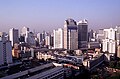
View over the district around Thanon Sukhumvit (near Phloenchit)
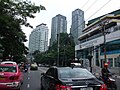
View over the district around Thanon Sukhumvit (near Nana)

Heavy traffic on Thanon Sukhumvit (into town), near Soi 18

Asok Junction (Sukhumvit and Ratchadaphisek)

Sukhumvit Soi 3 (Soi Arab)
Sukhumvit Soi 55 (Thong Lo)

.jpg)


Web links
Individual evidence
- ↑ DEM บริษัท ทางด่วน และ รถไฟฟ้า กรุงเทพ จำกัด (มหาชน). In: www.bemplc.co.th. Retrieved October 19, 2016 .
- ↑ Nana Plaza - Bangkok Hot Spots . In: bangkok.com . ( bangkok.com [accessed October 19, 2016]).
- ^ Sukhumvit Road. In: Sukhumvit Road - Thailand.TV. Retrieved October 19, 2016 .
Coordinates: 13 ° 44 ′ 31.4 " N , 100 ° 33 ′ 11" E