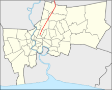
Thanon Phahonyothin
Thanon Phahonyothin ( Thai : ถนน พหลโยธิน , in English usage: Phahon Yothin highway) is one of the most important highways of Bangkok and next to Thanon Mittraphap , Thanon Sukhumvit and Thanon Phetkasem one of the four most important expressways in Thailand .
Thanon Phahonyothin is one of the main highways in Bangkok before it becomes " Highway No. 1 " (in English: Highway No. 1 ). In Thai usage it is only called “Thanon Phahonyothin”, which means Phahonyothin Street . It is part of the Asian Highway Network AH1 and AH2 and the Kunming-Bangkok Expressway .
history
Phahonyothin Road was originally only 22 kilometers long, it only led as far as Bangkok's Don Mueang district . At that time it was still called Prachathipatai Street ( ถนน ประชาธิปไตย , Thanon Prachathipatai , lit. "Democracy Street"). In 1938, Field Marshal Plaek Phibunsongkhram had the road extended so that it ran from Don Mueang via Bang Pa-In , Ayutthaya , Saraburi Province and Lop Buri Province to Sing Buri Province with a total length of 162 kilometers. The extended street was then named Phahonyothin Street ( Thanon Phahonyothin ) in honor of General Phraya Phahon Phonphayuhasena (Phot Phahonyothin), the second Prime Minister of Thailand and one of the leaders of the 1932 revolution .
Course of the road
The Thanon Phahonyothin begins in Bangkok's Ratchathewi district at the Victory Monument and connects the capital with northern Thailand . It has a total length of 1005 kilometers.
Within Bangkok it runs over a length of 24 kilometers through the northern districts of Phaya Thai , Chatuchak , Bang Khen and Don Mueang . On the street are the Ari nightlife district , the headquarters of the border police , the corporate headquarters of the mobile operator Advanced Info Service (AIS), the Chatuchak market and park , the Union Mall and CentralPlaza Lardprao shopping centers , the elephant building , the campus of the Kasetsart University with the Bangkok Aquarium , the Autobahn Administration (EXAT) and the state offices for forests as well as for national parks and species protection. Above the Thanon Phahonyothin, the Sukhumvit line of the Skytrain runs between the Victory Monument and Kasetsart University .
In the outer districts the road leads to the Sripatum University , a large area of the Thai army, the cemetery of the air forces, the "temple of democracy" Wat Phra Sri Mahathat and the air force base at Don Mueang airport with the Bhumibol-Adulyadej Hospital, Museum and Air Force Officers School. Beyond the city limits, but still in the greater Bangkok area, the street is lined with the huge Future Park Rangsit shopping center , the Thai mint, and the campus of Bangkok University , Thammasat University , the Asian Institute of Technology and Mahachulalongkornrajavidyalaya University .
Beyond the capital, the Phahonyothin Road continues through the provinces of Pathum Thani , Ayutthaya , Saraburi and Lop Buri in the north-central region. We continue through the northern Thai provinces of Nakhon Sawan , Chai Nat , again Nakhon Sawan, Kamphaeng Phet , Tak , Lampang , Phayao and Chiang Rai . It ends in Mae Sai , the northernmost city in Thailand. There is a border crossing to Tachilek in Myanmar .
On some sections of the route, the Phahonyothin Highway has lost its importance for long-haul connections. For example between Lop Buri and Chai Nat . Here, the six-lane Thailand Route 32 significantly shortened the travel time between Bangkok and northern Thailand.
Skytrain over and office buildings at Thanon Phahonyothin in Bangkok, Phaya Thai District
Thanon Phahonyothin in Chatuchak District
In the district of Ko Kha , Lampang Province
Individual evidence
- ↑ อร ณี แน่นหนา , 2002. นาม นี้ มี ที่ มา. ประพันธ์ สาส์น: กรุงเทพฯ.
Web links
- "In Isolated Hills of Asia, New Roads to Speed Trade" by Thomas Fuller New York Times, March 31, 2008 (last accessed November 16, 2008)
Coordinates: 13 ° 50 ′ 50.6 ″ N , 100 ° 34 ′ 48 ″ E


