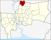
Don Mueang
| Don Mueang ดอนเมือง |
|
|---|---|
| Data | |
| Province: | Bangkok |
| Surface: | 36.803 km² |
| Residents: | 167,827 (2013) |
| Population density : | 4320 U / km² |
| ZIP : | 10210 |
| Geocode : | 1036 |
| map | |

|
|
| Bangkok boroughs | |
Don Mueang ( Thai ดอนเมือง , other spelling: Don Muang , pronunciation: [ dɔːn mʉaŋ ]) is one of the 50 khet (districts) in Bangkok , the capital of Thailand . Don Mueang is the northernmost district of the capital and is known for its international airport.
geography
The neighboring districts are clockwise from the north: Amphoe Mueang and Amphoe Lam Luk Ka of Pathum Thani Province , as well as the following Khet of Bangkok : Sai Mai , Bang Khen and Lak Si . To the west lies Pak Kret in the Nonthaburi province .
history
Don Mueang was once part of Bang Khen but became a separate district in 1989. Later in 1997, the southern part of Don Mueang was separated to form the new Lak Si District .
The old name of this area was Don E Yeo ( ดอน อี เหยี่ยว ), which means eagle and vulture plateau , as many of these birds lived here. The new name was given to the district by the King when the Royal Thai Air Force settled here.
Locations
- Don Mueang Airport
- Royal Thai Air Force Museum
administration
The district originally had only one sub-district ( Khwaeng ) , which was split into three sub-districts in 2009:
| No. | Name Khwaeng | Thai | Pop. |
|---|---|---|---|
| 1. | Si Kan | สี กัน | 62,410 |
| 2. | Don Mueang | ดอนเมือง | 81,706 |
| 3. | Sanam Bin | สนาม บิน | 23,711 |
Municipal council
The Don Mueang District Council has eight members, each member is elected for four years. The last election was on April 30, 2006. The results:
- Chart Thai Party - 7 seats
- Thai Rak Thai Party - 1 seat
traffic
Don Mueang owns a train station on the railway line leading north out of Bangkok, which serves the traffic of the northern railway and the northeast railway of the Thai state railway with the final destinations Chiang Mai , Nong Khai and Ubon Ratchathani .
Individual evidence
- ↑ Announcement with sketch map in the Royal Gazette (PDF file in Thai)
- ↑ 2013 population statistics ( Thai ) Department of Provincial Administration. Retrieved August 6, 2014.
Web links
- "Donmuang District Office" (in Thai)
Coordinates: 13 ° 55 ' N , 100 ° 35' E
