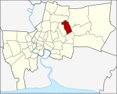
Khan Na Yao
| Khan Na Yao คันนายาว |
|
|---|---|
| Data | |
| Province: | Bangkok |
| Surface: | 16.662 km² |
| Residents: | 90,437 (2013) |
| Population density : | 5341 E./km² |
| ZIP : | 10230 |
| Geocode : | 1043 |
| map | |

|
|
| Bangkok boroughs | |
Khan Na Yao ( Thai คันนายาว , kʰān nāː jāːw ) is one of the 50 khet (districts) in Bangkok , the capital of Thailand .
geography
The neighboring districts are clockwise from the north: Bang Khen , Khlong Sam Wa , Min Buri , Saphan Sung, and Bueng Kum .
history
Khan Na Yao initially belonged to the Bueng Kum district. According to an administrative order dated October 14, 1997, he and Saphan Sung were separated from Bueng Kum. This ruling came into effect on November 21, 1998.
Attractions
- Wat Rassattadhum
administration
The district has two sub-districts ( Khwaeng ) :
| No. | Name Khwaeng | Thai | Pop. |
|---|---|---|---|
| 1. | Khan Na Yao | คันนายาว | 41,041 |
| 2. | Ram Inthra | รามอินทรา | 49,396 |
Municipal council
The Khan Na Yao District Council has seven members, each member is elected for four years. The last election was on April 30, 2006. The results:
- Thai Rak Thai Party - 7 seats
Individual evidence
- ↑ ประกาศ กระทรวง มหาดไทย เรื่อง เปลี่ยนแปลง พื้นที่ เขต บางเขน เขต ลาดพร้าว เขต บึงกุ่ม เขต ประเวศ และ ตั้ง เขต สายไหม เขต เขต คันนายาว เขต สะพาน สูง . In: Royal Gazette . 114, No. พิเศษ 108 ง , November 18, 1997, p. 6.
- ↑ Announcement with sketch map in the Royal Gazette (PDF file in Thai)
- ↑ 2013 population statistics ( Thai ) Department of Provincial Administration. Retrieved August 5, 2014.
Web links
- "Khannayao District Office" (in Thai)
Coordinates: 13 ° 50 ' N , 100 ° 41' E