Saphan Sung
| Saphan Sung สะพาน สูง |
|
|---|---|
| Data | |
| Province: | Bangkok |
| Surface: | 28.124 km² |
| Residents: | 91,358 (2013) |
| Population density : | 2908 U / km² |
| ZIP : | 10240, 10250 |
| Geocode : | 1044 |
| map | |

|
|
| Bangkok boroughs | |
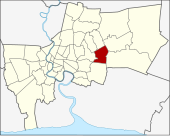
Saphan Sung ( Thai : สะพาน สูง , high bridge ) is one of the 50 khet (districts) in Bangkok , the capital of Thailand .
geography
The neighboring districts are clockwise from the north: Khan Na Yao , Min Buri , Lat Krabang , Prawet , Suan Luang , Bang Kapi, and Bueng Kum .
history
Saphan Sung originally belonged to the Bueng Kum District. According to an administrative order dated October 14, 1997, he was separated from Bueng Kum along with Khan Na Yao. The order came into force on November 21, 1998, and Saphan Sung has been a khet of its own ever since.
Saphan Sung means high bridge , which refers to the appearance of the Khlong bridges when the transport by boat over the canals of Thailand was the only way to transport goods from one place to another. These bridges were also called "Saphan Chang" ( elephant bridges ) because, firstly, they looked like the arched back of a working elephant, and secondly, these bridges had to be strong enough to support the weight of a full-grown elephant (see web links) .
Attractions
- Wat Latbuakhao
administration
The district has only one sub-district ( Khwaeng ) :
| No. | Name Khwaeng | Thai | Pop. |
|---|---|---|---|
| 1. | Saphan Sung | สะพาน สูง | 91,358 |
Municipal council
The Saphan Sung district council has seven members, each member is elected for four years. The last election was on April 30, 2006. The results:
- Democratic Party - 7 seats
Individual evidence
- ↑ ประกาศ กระทรวง มหาดไทย เรื่อง เปลี่ยนแปลง พื้นที่ เขต บางเขน เขต ลาดพร้าว เขต บึงกุ่ม เขต ประเวศ และ ตั้ง เขต สายไหม เขต เขต คันนายาว เขต สะพาน สูง . In: Royal Gazette . 114, No. พิเศษ 108 ง , November 18, 1997, p. 6.
- ↑ 2013 population statistics ( Thai ) Department of Provincial Administration. Retrieved August 5, 2014.
Web links
- "Saphansoong District Office" (in Thai)
Coordinates: 13 ° 46 ' N , 100 ° 41' E